Icon  Name                            Last modified      Size  Description
[Up] Parent Directory - [   ] ten_cat_nse.pdf 2021-05-05 10:43 244K [   ] ten_cat_R.pdf 2021-05-05 10:42 246K [IMG] ten_cats_nse.png 2021-05-03 08:46 32K [IMG] ten_cats.png 2021-05-01 08:02 32K [   ] ten_121.pdf 2021-04-30 10:40 425K [IMG] ten_tiles.png 2021-04-23 12:31 22K [   ] tennessee_river.pdf 2021-04-22 10:44 13K [IMG] res_coeff_kstream.png 2021-02-24 11:43 14K [Directory] GEOSroute/ 2021-02-02 08:41 - [Directory] BA/ 2020-12-22 07:12 - [Directory] CHM/ 2020-08-28 13:24 - [Directory] mkdir/ 2020-08-28 13:21 - [Directory] CATID/ 2020-08-17 12:11 - [Directory] SRTM_catchs/ 2020-08-07 14:27 - [Directory] Precip_Scale/ 2019-02-21 09:32 - [   ] SHIFT_PRCP_PDFs.pdf 2018-11-07 10:45 2.3M [   ] SHIFT_PRCP_PDFs_transformed.pdf 2018-11-06 13:41 5.5M [Directory] docs/ 2018-05-23 09:18 - [Directory] G6_UNSCALED/ 2018-04-08 10:06 - [Directory] G6_SCALED/ 2018-04-08 10:06 - [Directory] SB_SUMMARY/ 2018-04-06 11:10 - [Directory] SB_240_sRev4/ 2018-03-29 12:49 - [Directory] SB_240_sRev3/ 2018-03-29 12:49 - [Directory] SB_240_ScR_PDF/ 2018-03-29 12:49 - [Directory] SB_240_FixA/ 2018-02-23 11:37 - [Directory] SB_240/ 2018-02-22 15:28 - [   ] SHIFT_PRCP_floods.pdf 2018-02-05 15:25 402K [IMG] AU.jpg 2018-01-31 16:21 108K [   ] SHIFT_ALL_PDFs.pdf 2018-01-08 17:52 2.6M [IMG] precip_shift.png 2018-01-08 11:40 181K [Directory] monthly/ 2017-12-08 13:12 - [Directory] daily/ 2017-12-08 07:57 - [   ] smap_floods.pdf 2017-12-03 11:06 30K [Directory] basin_maps/ 2017-12-02 15:27 - [   ] res_coeff.pdf 2017-11-30 06:47 15M [IMG] boxplot.png 2017-11-09 13:40 170K [   ] 
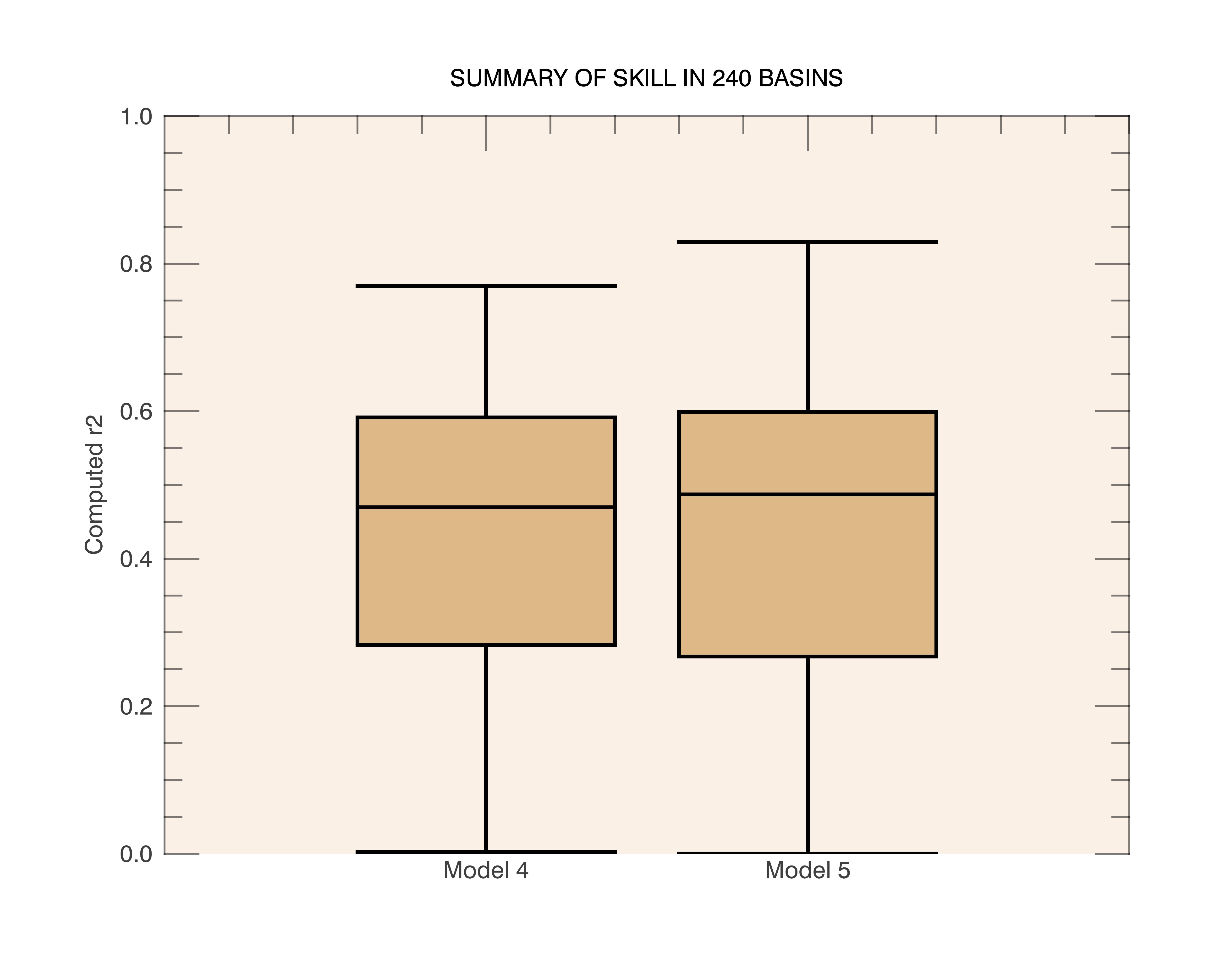
SUMMARY_R2 2017-11-09 12:14 13K [Directory] plots_159/ 2017-11-09 11:44 - [Directory] plots_240/ 2017-11-09 11:31 -