Icon  Name                           Last modified      Size  Description
[Up] Parent Directory - [TXT] CF-atmos_CF-ocean 2018-05-25 13:27 670 [IMG] 
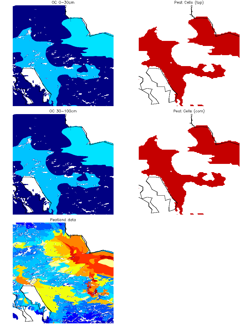
CF720_peattiles.png 2020-05-01 13:07 36K [   ] FPARAlb_Scaling_v2.pptx 2018-11-09 08:42 2.1M [Directory] FPAR_SCALING/ 2019-07-15 14:46 - [Directory] FlashDrought/ 2018-09-10 09:24 - [Directory] GEOS5_S2S/ 2019-01-15 10:04 - [TXT] GEOS_LandGridComp.rc 2019-08-06 17:26 4.5K [Directory] HSB/ 2020-08-27 16:02 - [IMG] LS_PRAMS_lai.jpg 2020-09-12 14:10 685K [Directory] MERRA3/ 2018-06-12 15:42 - [VID] MOD11A2.006.mp4 2018-04-22 17:12 17M [Directory] MODIS_DVG/ 2020-10-30 16:24 - [IMG] MOM5_1440x1080.png 2021-06-15 21:17 26K [IMG] MOM5_360x200.png 2021-06-15 21:17 23K [IMG] MOM6_360x210.png 2021-06-15 21:17 23K [Directory] MichelB/ 2021-04-15 11:18 - [Directory] ROUTING_MODEL/ 2021-05-05 10:48 - [Directory] S2S/ 2018-03-06 14:46 - [   ] 
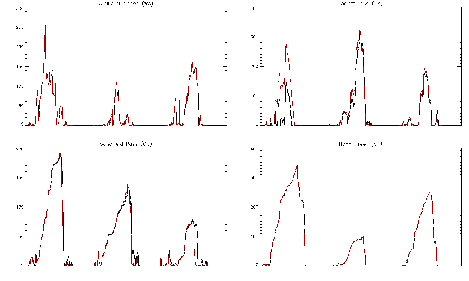
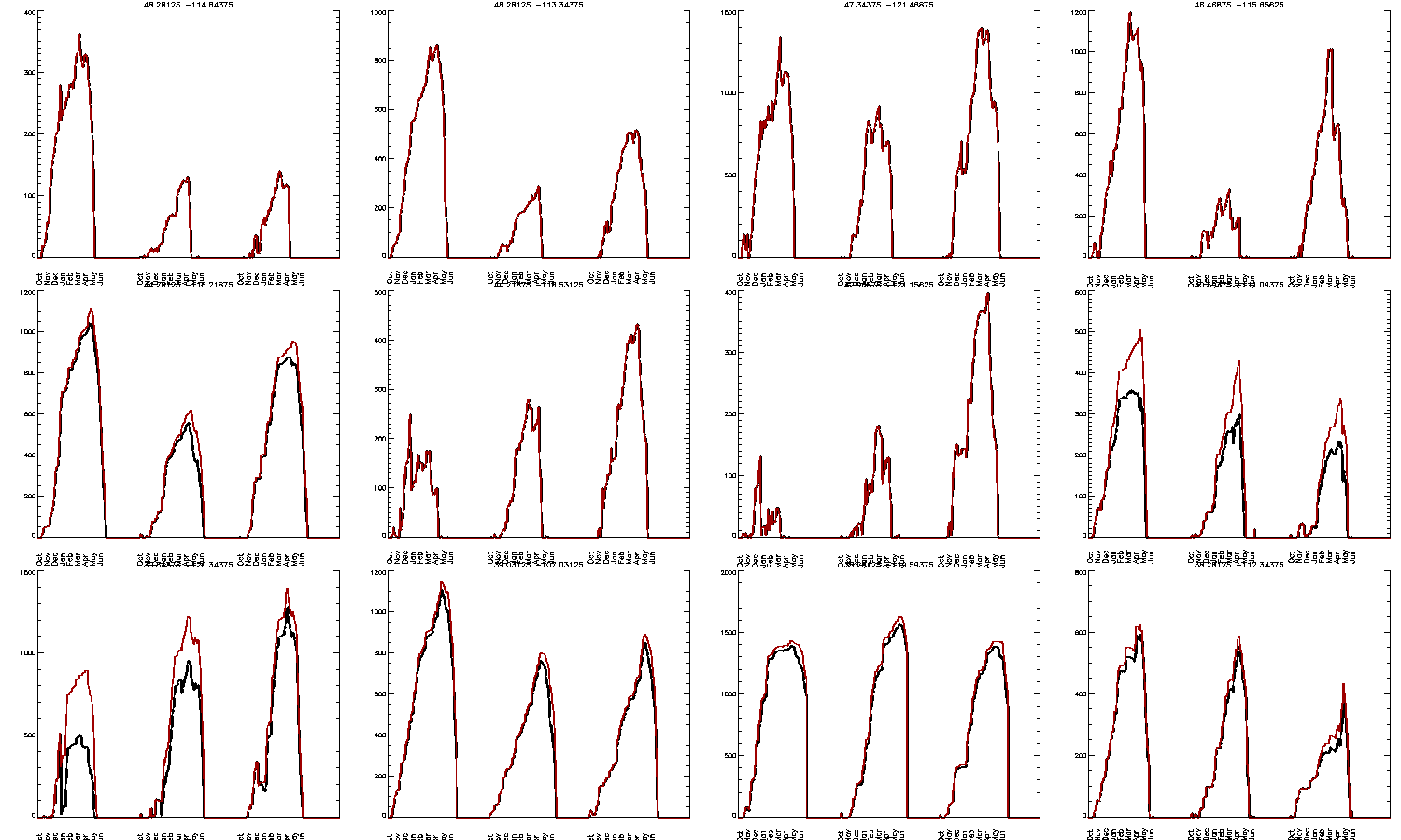
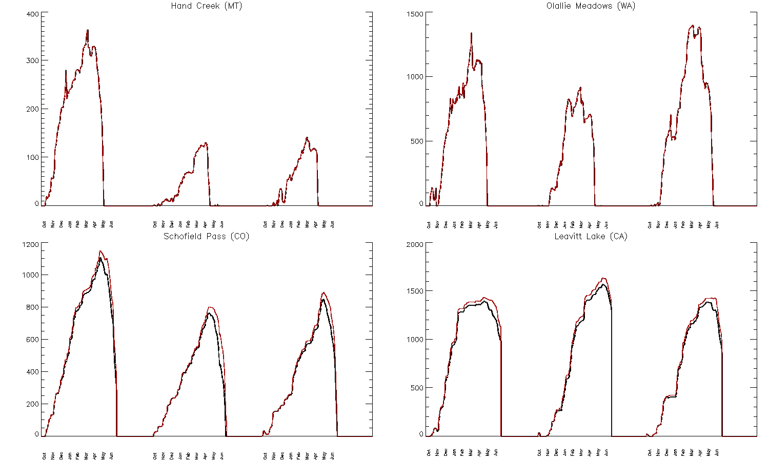
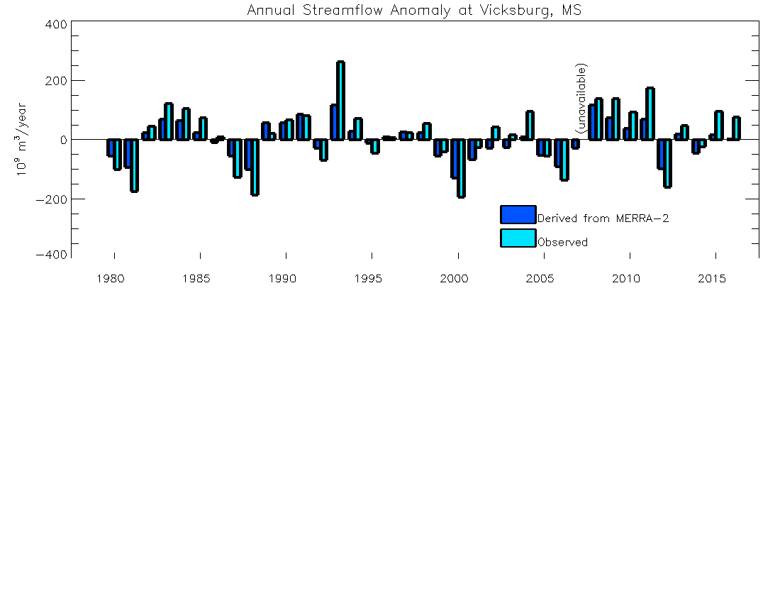
SCM_tseries.pdf 2020-06-17 00:03 92K [IMG] SWE.png 2018-10-12 10:59 22K [IMG] SWE12.png 2018-10-19 22:02 41K [IMG] SWE4.png 2018-10-19 22:14 26K [   ] SWLAND_diu.pdf 2021-06-15 16:48 225K [Directory] SatPara/ 2019-04-12 15:38 - [Directory] UCLA/ 2019-01-19 21:50 - [IMG] US-east.jpg 2021-01-20 10:01 408K [IMG] US-east_0.5.jpg 2017-09-01 11:27 148K [IMG] US-east_cf180.jpg 2020-09-26 09:52 416K [IMG] US-east_icarus.jpg 2021-01-20 09:59 280K [IMG] US-east_m36.jpg 2020-09-28 09:28 209K [   ] alb_histo.pdf 2021-06-16 13:09 126K [Directory] bcs/ 2019-05-08 11:22 - [TXT] clsm_ensdrv_force_routines.F90 2018-10-25 13:09 176K [IMG] eint_frac.png 2019-10-22 15:02 148K [IMG] eint_frac2.png 2020-05-03 16:04 65K [   ] fig1.pdf 2018-05-22 13:27 196K [TXT] getIrrigMethod.F90 2021-04-19 13:34 8.0K [   ] grnFrac_uk.nc 2014-06-20 11:43 12M [   ] histo.pdf 2021-03-30 14:28 31K [   ] histo2.pdf 2021-03-31 14:13 111K [   ] histo3.pdf 2021-04-02 10:26 59K [   ] id_rsa.pub 2021-03-25 12:19 401 [Directory] irrigation/ 2021-06-24 15:30 - [   ] jp.csh 2019-10-15 12:40 1.6K [IMG] lai_map_algorithm.jpg 2020-06-16 16:14 333K [IMG] malispland_m2amip02jan2016.png 2019-03-08 11:27 48K [Directory] matplot/ 2019-10-13 17:04 - [IMG] modis_lai_geosldas.jpg 2020-05-02 12:52 244K [IMG] page1.png 2021-02-05 15:13 9.5K [Directory] peatCLSM/ 2021-01-08 10:32 - [IMG] peatland.png 2019-05-14 06:36 59K [IMG] peatmap.png 2019-06-18 16:00 82K [TXT] process_modis.py 2019-08-05 16:10 16K [IMG] qp_frac.png 2019-10-22 15:03 59K [IMG] qp_frac2.png 2020-05-03 16:05 29K [IMG] qp_frac_agcm.png 2019-09-24 13:17 44K [IMG] qp_frac_agcm_diff.png 2019-09-24 17:09 31K [Directory] river_basin_infor/ 2019-07-21 21:50 - [IMG] soil_param.jpg 2019-05-13 15:09 454K [Directory] temp/ 2018-08-17 10:07 - [   ] test_pd.py 2019-08-02 01:00 1.5K [   ] topajos_basin_maps.pdf 2021-04-09 09:14 40K [IMG] vars_page00.png 2021-06-16 12:38 37K [IMG] vars_page01.png 2021-06-16 12:38 37K [IMG] vars_page02.png 2021-06-16 12:38 37K [IMG] vars_page03.png 2021-06-16 12:38 37K [IMG] vars_page04.png 2021-06-16 12:39 37K [IMG] vars_page05.png 2021-06-16 12:39 37K [IMG] zone_00.png 2021-06-09 07:02 5.4K [IMG] zone_01.png 2021-06-09 07:02 6.5K [IMG] zone_02.png 2021-06-09 07:03 5.8K