

Google Earth Engine Data Fusion Tool to support Air Quality Managers
See snapshot in Portuguese
See powerpoint snapshot in Portuguese
See snapshot with 4:3 aspect ratio in Portuguese
Many information sources can support air quality assessment and forecasting, including atmospheric chemistry models, satellite retrievals of column chemical and aerosol constituents, and surface-based air quality monitoring data from both regulatory and low-cost instruments. Systematic integration of these data sources provides a major opportunity to improve the understanding and management of air quality. However, doing so presents numerous technical challenges, and can be a daunting task for air quality managers, especially those working in resource-constrained settings.
Supported by the NASA Health and Air Quality Applied Sciences Program, a team of scientists from the GMAO are collaborating with Sonoma Technology, Inc., and others to implement an air quality data fusion tool using the Google Earth Engine platform. As outlined in the diagram below, this tool will combine global information sources, like the GMAO GEOS-CF atmospheric composition forecast and satellite products from NASA VIIRS and ESA TROPOMI, with locally collected air quality data from regulatory instruments and low-cost sensor networks. Using these inputs, the tool will produce hourly estimates and near-term forecasts (up to several days in advance) of key air quality parameters (PM2.5, NO2, O3) relevant at sub-city (1-5 km) scales, supporting comprehensive assessment and management of local air quality.
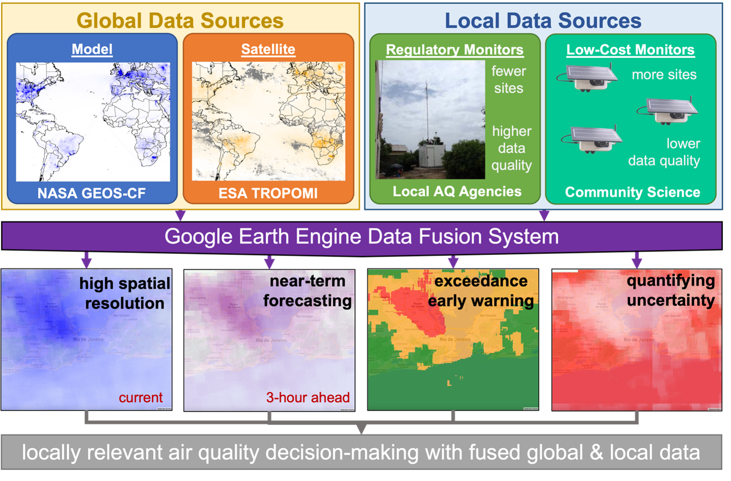
This data fusion tool will also include uncertainty quantification capabilities, conveying the relative confidence in estimates and forecasts based on which data sources informed them. The data fusion system will assess the level of agreement between low-cost sensors and other data sources before incorporating the low-cost sensor data, allowing users to assess the utility and calibration performance of low-cost sensor networks in their region. Availability on Google Earth Engine will make the system accessible to US and international air quality mangers; GEOS-CF outputs are already available through Google Earth Engine as highlighted in a recent science snapshot. Altogether, the system will allow air quality managers to better understand their local air quality situation based on a combination of multiple available data sources. It will also provide insight into what additional information sources might best advance their knowledge of local air quality.
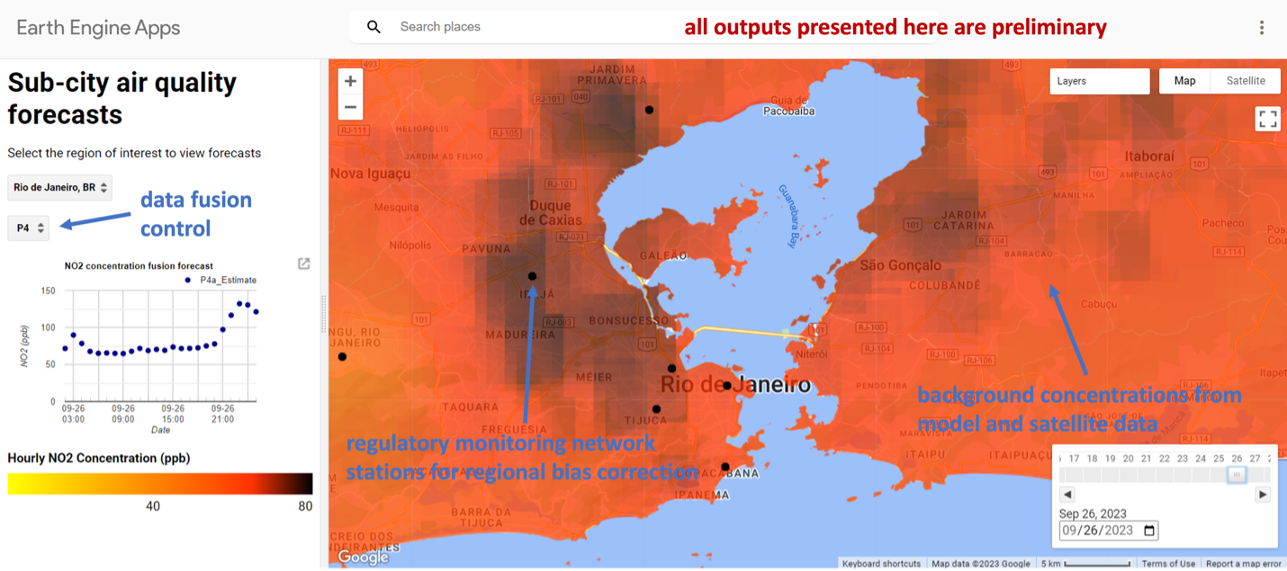
The project team is working with several US and international air quality managers to develop the basic capabilities of this data fusion tool and to integrate it into their management workflows. Currently, a prototype data fusion tool has been developed and is undergoing testing and further refinement. A screenshot from this prototype showing a sample air quality forecast map derived from model, satellite, and ground-based measurement data is provided below, covering an area of Rio de Janeiro, Brazil. This project builds upon an existing NASA-Rio partnership by developing tools to help air quality managers supplement their existing ground-based monitor network. Surface-level NO2 concentrations (orange shading) are derived from a combination of the GEOS-CF forecasts, downscaled using recent atmospheric column NO2 retrievals from the ESA TROPOMI satellite instrument, and corrected regionally to better match recent measurements of the ground-based air quality monitoring network (black points). For PM2.5 estimation, aerosol optical depth information from NASA VIIRS will be utilized in place of the TROPOMI data. Estimates and forecasts might then be locally refined in the vicinity of low-cost sensor data (not depicted here), provided that good agreement has been established between the low-cost sensor and the best available estimates from the other data sources during recent verification. All these data fusion steps are automated within the Google Earth Engine platform and can be toggled (controls at left) based on data availability or user preference.
Through the ongoing development process, the team will assess the tool’s ability to address user needs, both in terms of the quantitative accuracy of estimates and forecasts and in terms of helping better represent air quality at fine spatial scales by combining multiple data sources. At the conclusion of the project, the developed data fusion tool and associated materials will be handed over to the US Environmental Protection Agency (EPA) and United Nations Environment Programme (UNEP) for ongoing curation and to help more air quality managers in the US and internationally to integrate the tool into their practices using lessons learned during this project.
The project will provide many benefits for local air quality managers. It will enhance their forecasting capabilities, especially for regionally transported pollutants. The tool will provide high resolution information about the spatial distribution of pollutants at sub-city scales and at relatively high (hourly) temporal frequency. The data fusion estimates and their associated uncertainties can help air quality managers to assess the regional representativeness of regulatory air quality monitoring networks, as well as to assess the accuracy and suitability of low-cost sensor data to supplement these networks. Finally, the tool will allow them to determine whether local phenomena such as coastal breeze effects, industrial emissions, or regulatory decisions are well captured via the fusion of available information sources, or whether other local information might be needed.