
Summary of GMAO Field Campaign Support for 2016
01.24.2017
Austin Conaty
GMAO supported nine different field campaigns in 2016, which implied an extremely busy year for the Operational Production. The geographical extent of these campaigns spanned the entire globe, from the North Pole to the South Pole, with numerous locations in between. The environments of scientific study were primarily the oceans and the atmosphere.
| Campaign | Period | Location | Science Objective | Contact |
|---|---|---|---|---|
| ORCAS | JAN-FEB | Punta Arenas, Chile and Antarctica | Survey of O2, N2, CO2 and related gases | M. Gierach |
| AfriSAR | FEB-MAR | The Gabon Africa | Studying rain forests and mangrove forests with LVIS sensor | M. Hofton |
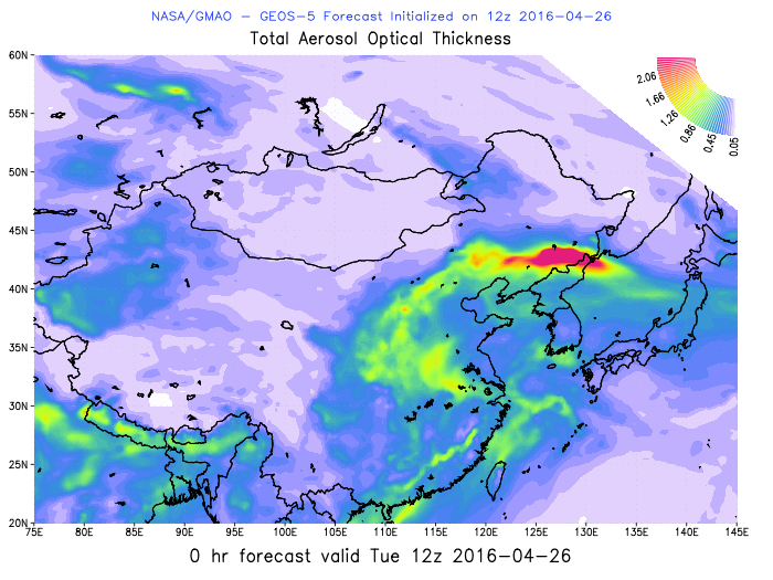
| KORUS-AQ | APR-JUN | South Korea | Intense observation of Air Quality | A. da Silva |
| NAAMES EV-S | MAY-JUN | NW Atlantic | Study ocean systems and impacts on atmospheric aerosols and clouds and implications for climate | R. Ferrare |
| ATom | JUL-AUG | 11 flights from near pole to near pole | Study impact of human pollution on greenhouse gases | P. Newman |
| ORACLES | AUG-SEP | Namibia, Africa | Aerosol cloud interactions in the SE Atlantic | A. da Silva |
| CARAFE | SEP-OCT | Out of WFF in Virginia | CH4, CO2 and water fluxes | P. Newman |
| POSIDON | SEP-OCT | Tropical Western Pacific via Guam | Pacific Oxidants, Sulfur, Ice, Dehydration, and Convection | K. Rosenlof |
| CORAL | SEP-OCT | Great Barrier Reef in Australia | Analyze the status of coral reefs and predict their future | M. Gierach |
ORCAS
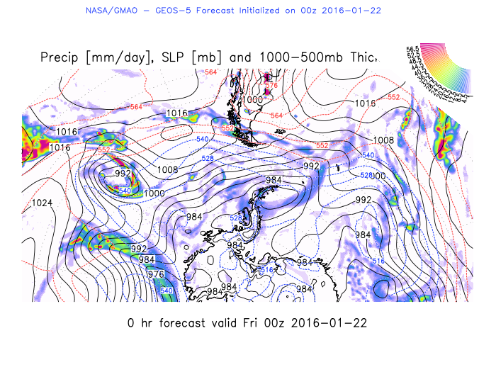
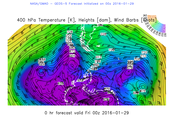
ORCAS Field Campaign took place in January-February 2016 and was based out of Punta Arenas, Chile. The O2/N2 Ratio and CO2 Airborne Southern Ocean (ORCAS) study consists of an intensive airborne survey of atmospheric O2, CO2, related gases, and ocean surface properties (e.g., hyperspectral ocean color remote sensing measurements) over diverse biogeochemical regions adjacent to the southern tip of South America and the Antarctic Peninsula. The PI for ORCAS is Charles McClain of NASA GSFC. The weather maps are used to assist in making flight planning decisions for the upcoming days. In some cases, depending on the conditions, the aircraft will need to avoid temperatures cold enough to turn jet fuel into a gel. In other cases the forecast will provide forecasts for areas where favorable cloud or precipitation conditions are expected. GMAO produced routine plots of meteorological fields, such as this example showing sea-level pressure and precipitation on January 22, 2016.
Images: slp/precip forecast plot (left), 400 hPa temperature and winds (right).
AfriSAR
AfriSAR Field Campaign took place in February-March 2016 and was based in Gabon, Africa. GMAO members Marangelly Cordero-Fuentes, Gary Partyka and Austin Conaty provided weather briefings via email, including plotted maps, to be used as an aid in flight planning activities. NASA studied rain forests and mangrove forests using both the Land, Vegetation, and Ice Sensor (LVIS) laser altimeter instrument and the Uninhabited Aerial Vehicle Synthetic Aperture Radar (UAVSAR). During the AfriSAR (Africa Synthetic Aperture Radar) campaign, UAVSAR flew at 40,000 feet high mounted beneath a C-20A aircraft from NASA’s Armstrong Flight Research Center, Edwards, California, while LVIS flew at 28,000 feet onboard a B-200 airplane from NASA’s Langley Research Center in Hampton, Virginia. The PI for AfriSAR was Christy Hansen of NASA GSFC.
KORUS-AQ
KORUS-AQ: An International Cooperative Air Quality Field Study in Korea. KORUS-AQ took place in April-June 2016. A team of GMAO members, Karla Longo de Freitas, Patricia Castellanos and Arlindo da Silva, joined the mission to provide GEOS forecasts used in weather briefings to aid in flight planning decisions. USA and Korea had more than 80 teams of scientists and support personnel contributing to the study. The Steering group was made up of more than 15 Korean and US members. The Mission Scientist was James Crawford of NASA LaRC.
Images: Aerosol plot for KORUS-AQ (left), station locations map (center), and sample datagram provided for each KORUS-AQ station indicated (right).

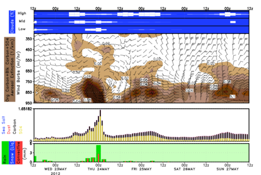
NAAMES EV-S
NAAMES EV-S Campaign took place in May-June 2016. North Atlantic Aerosols and Marine Ecosystems Study (NAAMES) investigates how marine ecosystems and aerosols interact such as how the plankton ecosystem of the ocean affects climate and life on Earth. The EV-S mission focused on studying the coupled ocean ecosystem and atmosphere. A combination of aircraft and a research vessel out of Woods Hole Oceanographic Institute are used to take measurements. The GEOS forecasts proved useful early on in this campaign when carbon monoxide and black carbon emissions were entering the NAAMES study region from Canadian wild fires. The PI for NAAMES EV-S was Mike Behrenfeld of Oregon State University.
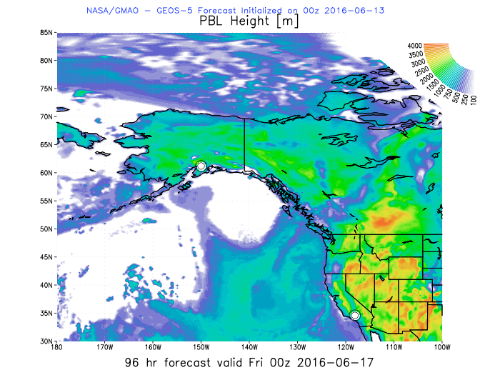
AToM
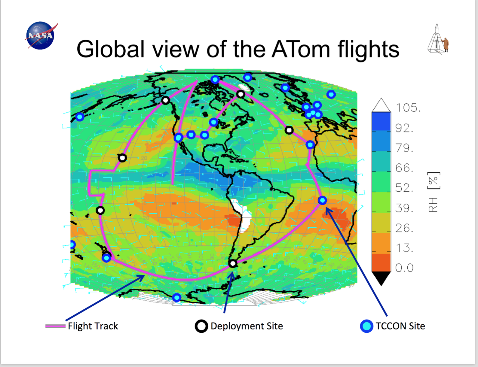
AToM Field Campaign first leg took place in July-August 2016. AtoM is the Atmospheric Tomography Mission. GMAO provided GEOS forecast regions for each of the 10 takeoff and landing sights and datagrams for the takeoff and landing sites as well. AToM studies the impact of human-produced air pollution on greenhouse gases and on chemically reactive gases in the atmosphere. Reductions of atmospheric concentrations of methane (CH4), tropospheric ozone (O3) and black carbon (BC) aerosols are effective measures to slow global warming and to improve air quality. Airborne instruments will look at how atmospheric chemistry is transformed by various air pollutants and at the impact on CH4 and O3. Mitigation of these short-lived climate forcers is a major component of current international policy discussions.
The campaign is using around 20 instruments on the NASA DC-8. This July-August 2016 campaign was the first of four deployments that that will conclude in Spring 2018. There are 10 flights in each deployment. The flights basically go near pole-to-near pole in both the Pacific and Atlantic sectors of the globe (see the region for Palmdale to Anchorage flight on left and all AToM flights below right). The PI for AToM is Steven Wofsy of Harvard.
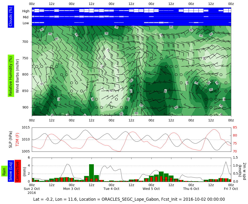
ORACLES
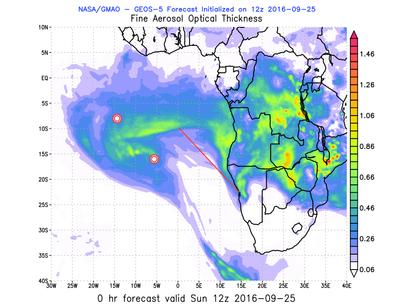
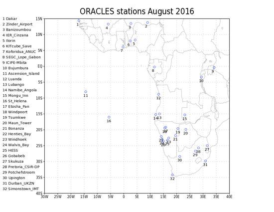
ORACLES Field Campaign took place August-September 2016. The ORACLES (ObseRvations of Aerosols above CLouds and their intEractionS) is a five-year investigation with three Intensive Observation Periods (IOP) designed to study key processes that determine the climate impacts of African biomass burning aerosols. It will provide multi-year airborne observations over the complete vertical column of the key parameters that drive aerosol-cloud interactions in the SE Atlantic, an area with some of the largest inter-model differences in aerosol forcing assessments on the planet. Instruments will be flown on NASA ER-2 and P-3 aircraft. PI for ORACLES was Jens Redemann of NASA ARC.
GMAO members Arlindo da Silva, Patricia Castellanos, Karla Longo, along with Susanna Bauer from GISS, provided GEOS forecast support to aid in aircraft mission planning for ORACLES. ORACLES is a NASA Earth Venture Suborbital project, with month-long deployments scheduled for the Fall of 2016, 2017 and 2018. Flights originated out of Namibia. (Aerosol plot shown below left, location of participating ground station locations below, center, and sample datagram provided for each station location, below right.)
CARAFE
CARAFE Field Campaign took place in September-October 2016. CARbon Airborne Flux Experiment (CARAFE) is a test and science flights mission that is designed to measure carbon dioxide (CO2), methane (CH4), and water fluxes. The overall CARAFE objective is to assemble a NASA airborne system for eddy covariance measurements of regional greenhouse gas (GHG) fluxes and to use this system to obtain GHG flux data for a range of ecosystem states and land use regions. Such measurements are needed to evaluate CO2 and CH4 top-down and bottom-up source and sink estimates. These observations will validate top-level OCO-2 products and those from other space-based GHG missions, while testing and improving parameterization of biogeophysical flux models. GEOS forecasts were made available for the requested East Coast USA region where CARAFE flights took place. GEOS forecasts were used when planning upcoming flights from Wallops Island Flight Facility. Randy Kawa of NASA GSFC is the PI for CARAFE.
POSIDON
POSIDON Field Campaign took place in September–October 2016. Flights were based in Guam. The NASA WB57 flew ~50 hours of flights for the Pacific Oxidants, Sulfur, Ice, Dehydration, and cONvection (POSIDON) Experiment. This campaign was a focused airborne science mission to study the chemistry and microphysics of sulfur, cirrus clouds, and dehydration in the tropical upper troposphere and lower stratosphere over the Tropical Western Pacific Warm pool. Instruments on board measured sulfur dioxide, water vapor, aerosol size distribution, ice water content, cloud particle measurements (size distributions and ice habit), ozone, temperature and winds, and a variety of chemical species of varying lifetimes (from the Whole Air Sampler and PANTHER instruments). GEOS forecasts were made available for the specified POSIDON region. Science Management of this field campaign was shared by Ru-Shan Gao of NOAA ESRL, Eric Jensen of NASA ARC, and Ken Jucks of NASA HQ.
CORAL
CORAL Field Campaign took place September-October 2016. The goal of the COral Reef Airborne Laboratory (CORAL) is to provide critical data and new models needed to analyze the status of coral reefs and to predict their future. CORAL will provide the most extensive picture to date of the condition of a large portion of the world's coral reefs from a uniform data set. The data will reveal trends between coral reef condition and biogeophysical forcings, both natural and those arising from human activities. With this new understanding of reef condition, better predict can be made of the future of this global ecosystem. This first leg of CORAL was centered around the Great Barrier Reef in Australia. GEOS forecasts were used to assist in flight planning possibilities. The PI for CORAL was Eric J. Hochberg of Bermuda Institute of Ocean Sciences.
See also: Previous Years' NASA Field Campaigns Supported by GMAO