Influence of Orography on the Stratosphere
The effects of orography (mountains and other terrain) can often be seen to perturb stratospheric winds far downstream of the location of the orography. These downstream wind perturbations show up as filaments of Ertel potential vorticity (EPV) when viewed on maps of mid-stratospheric potential vorticity. While the newer high horizontal resolution atmospheric data assimilation systems and models are now regularly displaying these filaments, the very high resolution (7 km) "Nature Run" produced in 2014 by the NASA Global Modeling and Assimilation Office provides a unique opportunity to examine their structure in detail.
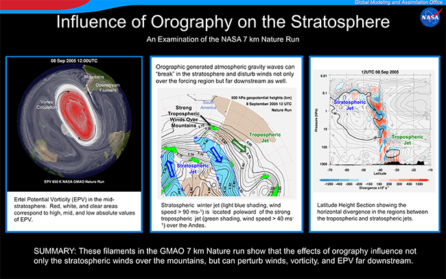
The right figure provides an example of a single filament in the Nature Run where the vertically propagating gravity waves (GWs), generated by the Southern Andes Mountains and "breaking" in the mid-stratosphere (about 30 km), act as the origin of a well-defined filament extending downstream of the mountains. The Ertel potential vorticity (or EPV), based on dynamical quantities, such as winds and temperatures, tends to be well conserved in the stratosphere so that it serves as a tracer of the wind field. In the figure, red denotes a region of strong EPV in the center of the wintertime stratospheric polar vortex at an altitude in the mid-stratosphere, white denotes weaker EPV that is characteristic of the vortex edge and mixing region outside the vortex, and transparent regions denote very weak EPV. The cyclonic flow characteristic of the wintertime vortex is suggested by the black curved arrows. While generally conserved, EPV can be disturbed by large amplitude, overturning (breaking) internal GWs, that are commonly generated by strong flow over mountains. The breaking GW generated, EPV perturbation takes the form of a redistribution of EPV into high and low regions (white and transparent in this case) that are subsequently advected downstream (the white and transparent filaments).
For the orography to generate GWs that break in the middle stratosphere the winds from the surface to the middle stratosphere have to have approximately the same direction. The center figure shows the location of the tropospheric jet stream (green arrow) and the stratospheric jet (blue arrow), with strong upper tropospheric flow (over 40 m/s) into the mountains producing large amplitude gravity waves over the mountain at this time. The consistency of the wind direction with altitude allows the GWs to propagate up to the mid-stratosphere. Internal GWs act to transmit the stress or drag on the flow over the mountain to higher altitudes. As the GWs propagate upward the density decreases, causing the GW amplitude to increase as the GW energy is conserved. Eventually the amplitude becomes large enough for the GW to overturn (break) and these altitudes are where the surface drag is felt. GW drag is a significant component of the global stratospheric momentum budget and circulation and is a major driver of the global, pole-to-pole, mesospheric circulation.
The left figure shows a south-to-north cross section of the horizontal divergence field generated by the flow over the mountains in relation to the tropospheric and stratospheric jets. The vertical axis extends from the surface (1000 hPa) through the mid-stratosphere (10 hPa, ~30 km), the stratopause (1 hPa, ~55 km) up to the upper-mesosphere (0.01 hPa, ~80 km). The cross-section is oriented along the white line in the center figure. GWs show up clearly in horizontal divergence, a measure of the winds moving toward and away from each other. The GWs perturb the equatorward side of the stratospheric jet, distorting the equatorward edge of the jet (heavy contour at 60 m/s) leading to a perturbation in EPV near the 10 hPa (mid-stratospheric) level. These disturbances in PV are "frozen" into the stratospheric flow and advected downstream forming the filaments. This figure especially highlights the vertical extent of the mountain effects in the atmosphere.


