OCO-2 and GEOS Team Up to Produce a New View of Carbon Dioxide
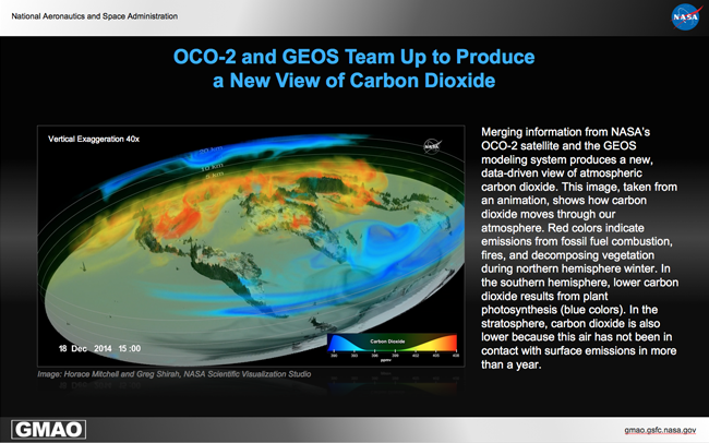
Combining observations from NASA's Orbiting Carbon Observatory 2 (OCO-2) satellite with information from the GEOS modeling system, GMAO scientists have created a new data-driven view of atmospheric carbon dioxide. The process of combining modeled and observed information, called data assimilation, has been used to inform numerical weather predictions for decades, but with Earth system modeling systems expanding to include a more diverse set of processes, these techniques are now being applied to study greenhouse gases and air quality. OCO-2 is NASA’s first mission dedicated to observing atmospheric carbon dioxide from space, providing about 100,000 observations of column-averaged mixing ratio per day.
Animations produced by NASA’s Scientific Visualization Studio show how differences between the model and satellite work together to create the merged analysis fields shown (https://svs.gsfc.nasa.gov/4519) and how scientists use these fields to study the movement of carbon dioxide through the atmosphere (https://svs.gsfc.nasa.gov/12445). Changes in atmospheric carbon dioxide concentrations have been reported for many years as a single number that highlights the growth rate of ambient atmospheric concentrations. However, carbon dioxide has important regional and seasonal variations that come from the influence of human emissions and natural land and ocean sinks. The atmospheric growth rate arises from the balance between the emissions from fossil fuel, biomass burning, respiration and photosynthesis, and regional uptake and release from the oceans, the natural processes of respiration and photosynthesis, full understanding of the carbon cycle. Scientists are currently using data assimilation techniques along with OCO-2 data to study these variations and to eventually improve source and sink distributions.
Please visit https://www.nasa.gov/feature/goddard/2016/eye-popping-view-of-co2-critical-step-for-carbon-cycle-science for more information.


