
Mapping Man-made CO2 from Space
Fossil fuel CO2 emissions (FFCO2) are the largest driver of atmospheric CO2 increases over decadal time scales. Inversion studies seek to estimate ocean and land carbon fluxes, which are regarded as being more uncertain, using atmospheric CO2 observations and transport models. However, unlike land biospheric fluxes and oceanic exchange, FFCO2 is often assumed to be a perfect quantity and is not optimized in the inverse estimation framework. To fully exploit denser CO2 data brought by carbon observing satellites such as Japanese Greenhouse gas Observing SATellite (GOSAT) and NASA’s Orbiting Carbon Observatory (OCO-2) in support of improved flux estimates, FFCO2 needs to be characterized more accurately in atmospheric CO2 transport simulations.
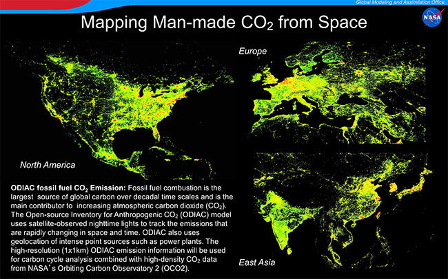
The ODIAC (Open-source Data Inventory for Atmospheric CO2, Oda and Maksyutov 2011) model disaggregates country emission estimates and produces global FFCO2 field over land at a very high (1x1km) spatial resolution. Spatial distributions of emissions were estimated using satellite-observed nighttime lights collected by the Defense Meteorological Satellites Program (DMSP) satellites as well as power plant profiles (emissions and geolocation). Satellite-observed nighttime light is an excellent indicator of human activities and allows us to keep track of FFCO2 spatial extents that are rapidly changing in space and time. The ODIAC model employs power plant geolocation taken from the global power plant database CARMA (CARbon Monitoring and Action, www.carma.org/). Emissions from power plants often account for significant portions of country emissions and do not collocate with human population. The use of power plant geolocation allows us to pinpoint the intense point sources. The combined use of nightlight observation and power plant profiles for disaggregation of country emissions enables us to map emissions at much higher spatial resolution than other studies.
The latest version of the ODIAC model (version 3.0) is further improved/upgraded from the original version presented in Oda and Maksyutov (2011). Emission estimates in ODIAC ver. 3.0 are taken from country emission estimates made by the Carbon Dioxide Information Analysis Center (CDIAC) at Oak Ridge National Lab (ORNL). Because CDIAC estimates often have 2 year time lag, CDIAC emissions for recent years are projected based on fuel consumption statistics published by BP (British Petroleum). This is particularly useful for analyzing satellite CO2 data that comes in near real time. In collaboration with CDIAC, emissions from international bunkers were derived and then mapped using available and suitable proxy data. Seasonal variations of land emissions are introduced from temporal profiles in the CDIAC monthly gridded product and AERO2k for aviation emissions. Temporal scaling parameters have been developed by an international research group, using Vulcan, EDGAR and other available resources, that specify weekly and diurnal patterns in emissions (Nassar et al. 2013). At the GMAO, the high-resolution ODIAC FFCO2 data will be used for upcoming carbon cycle analyses using OCO-2 data.
References
Oda, T. and Maksyutov, S.: A very high-resolution (1 km × 1 km) global fossil fuel CO2 emission inventory derived using a point source database and satellite observations of nighttime lights, Atmos. Chem. Phys., 11, 543-556, doi:10.5194/acp-11-543-2011, 2011.
Nassar, R., L. Napier-Linton, K. R. Gurney, R. J. Andres, T. Oda, F. R. Vogel, and F. Deng (2013), Improving the temporal and spatial distribution of CO2 emissions from global fossil fuel emission data sets, J. Geophys. Res. Atmos., 118, 917–933, doi:10.1029/2012JD018196.