
Forecasting the Ft. McMurray Fire in GEOS-5
NASA’s GEOS-5 model includes the unique capability to forecast aerosol and trace gas pollution along with weather in near real-time. Fire emissions are estimated daily using fire radiative power from MODIS (Darmenov et al., 2015) instruments located on the Terra (http://terra.nasa.gov/) and Aqua (http://aqua.nasa.gov/) satellites. Short term fire forecasts are created by assuming that fire emissions persist in the future, meaning that a fire observed today would still be burning at the same rate 10 days from now. These emissions are combined with GEOS-5 weather forecasts, produced by combining millions of observations of weather and aerosols every 6 hours to create a realistic starting point, to predict the evolution of fire pollution plumes.
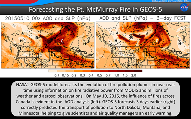
The ability of high resolution global weather models to correctly predict the pathways for pollution transport several days in advance is critical for air quality managers, who are responsible for warning the public of potentially dangerous conditions, and scientists, who continue to work to better understand these events. In May 2016, fires in British Columbia (A), Fort McMurray (B), and Manitoba (C) resulted in high aerosol optical depths (AODs) across Canada in the GEOS-5 aerosol analysis (left). The analyzed field, which combines the GEOS-5 forecast with satellite AOD observations, can be used to evaluate the quality of the aerosol forecasts. The 3-day forecast (right) captures the meteorological situation remarkably well, correctly predicting the development of low pressure systems in mountain west states and northern Canada, and high pressure to the east over Ontario. Smoke from the Canadian fires was transported counterclockwise around the low pressure systems and clockwise around the high pressure airmass resulting in the complex spatial distribution observed from space.
While the meteorological conditions were forecast well in this case, forecasting fire emissions remains a challenging area in need of further research and development. A comparison of the AOD analysis and 3-day forecasts shows that the emissions over British Columbia (A) were too large, likely because the model assumes a fire persists at its current level of activity for multiple days, which is not always the case. Emissions from the larger fires over Ft. McMurray (B) and Manitoba (C) were underestimated in the 3-day forecast resulting in underestimates of the level of pollution reaching North Dakota, likely because these fires grew more intense and emissions increased over time. Research is ongoing to develop models that incorporate weather information to more realistically forecast fire emissions in the future.
References
Darmenov, Anton, and Arlindo da Silva, 2015. The Quick Fire Emissions Dataset (QFED): Documentation of versions 2.1, 2.2 and 2.4. NASA/TM–2015–104606, Vol. 38.