
A Slinky-fied View of a Frozen-In Anticyclone in MERRA-2
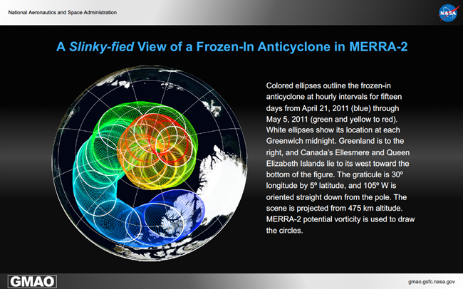
This illustration shows the spiral path of a drifting anticyclonic vortex, a tube of air rotating clockwise, in the northern middle stratosphere at approximately 32 km elevation. The vortex was first analysed by MERRA-2 over central Asia in early April when it was generated in the shear zone on the equatorward flank of the decaying polar-night jet. As a consequence of the dynamics of 2011, the vortex was transported in four days toward the northeast across Siberia and the southern Arctic Ocean off the coasts of Alaska and Canada. After executing two lazy meandering loops, it came to rest on April 16 over Ellesmere Island, west of northern Greenland. On April 21, as the figure illustrates, it started drifting to the west and within a few days toward the north.
The vortex was embedded nearly at the center of a much larger pool of air that was also rotating anticyclonically. Because of the event’s timing in the spring just after the stratosphere’s final warming, this pool of low-potential vorticity, formerly low-latitude air, became the seed of 2011’s summertime circulation. During the 15 days depicted in the illustration, radiative forcing moved the center of the circulation onto the pole, which is why the vortex traces a spiral path. By May 6, the summer’s easterly, circumpolar flow was established.
The stratosphere’s summertime circulation has weak horizontal and vertical shear. Already three weeks old by April 21, the vortex stayed distinct and identifiable for another month until early June. Similarly behaved vortices were observed in 2003, 2005, and 2007. Their generation, or at least the timing thereof, may be linked to the easterly phase of the tropical quasi-biennial oscillation. Noted for their persistence and trapped by the stratosphere’s winds, they are called “frozen-in anticyclones,” — fated to circle westward around the pole until their demise.