
A Neural-Network-Based Bias Correction Enhances the Value of Aquarius Sea Surface Salinity (SSS) Data
While sea surface temperature (SST) is a key component in air-sea exchanges of heat, sea surface salinity (SSS) is required for the determination of surface density which dictates the formation of water masses and therefore has a significant influence on the global ocean circulation at large spatio-temporal scales. It has also been argued that a proper estimation of SSS is required for the closure of the marine hydrological budget, since salinity variability is correlated with the net evaporation minus precipitation. Therefore, retrieving SSS at global scale opens the possibility of using surface salinity to constrain the estimation of air-sea freshwater fluxes, and improve our understanding of the ocean-atmosphere coupling.
SSS is routinely monitored in the upper 10 m by a series of Argo buoys/profiling floats. However, these in-situ measurements sample only a small fraction of the ocean, and then only infrequently. SSS measurements are also often collected from ships along shipping routes. Recently, the use of gliders has increased, but these measurements remain localized and sporadic. Since 2009, two satellite missions started operating: the European Space Agency (ESA) Soil Moisture Ocean Salinity (SMOS) mission, and the Aquarius/SAC-D mission (started in November, 2011) developed collaboratively between the U.S. National Aeronautics and Space Administration (NASA) and the Argentine space agency, Comisión Nacional de Actividades Espaciales (CONAE). These satellite observations provide global and synoptic-scale SSS data, which constitute major contributions to the ocean observing system.
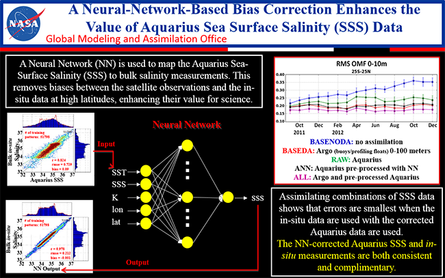
Satellite SSS retrievals are performed with a 0.2 Practical Salinity Units (PSU) precision in the tropical waters and small biases. However, significant biases have been identified between the satellite retrievals and in-situ measurements at higher latitudes. Therefore, the use of satellite SSS retrievals by itself may be more challenging at high latitudes, in cold waters with rough surfaces. This limitation can be tackled using satellite retrievals in conjunction with in-situ measurements and a data assimilation system.
The root mean square (RMS) of the salinity observation minus forecast (OMF) at Argo locations, where OMF is defined as the difference between the in-situ bulk salinity measurements and the one-day-lead model forecast from the previous analysis. The OMF statistics shed light on the performance of each experiment and help further quantify the impact of SSS assimilation. The best performance for the ANN experiment is observed in the tropics and south of 25S, where RMS OMFs are generally smaller than in BASEDA and at times is not significantly different from ALL. There are fewer in-situ measurements in the Southern Oceans and the preprocessed Aquarius fills up the measurement void with observations of comparable quality.
Reference:
Vernieres, G., R. Kovach, C. Keppenne, S. Akella, L. Brucker, and E. Dinnat (2014), The impact of the assimilation of Aquarius sea surface salinity data in the GEOS ocean data assimilation system, J. Geophys. Res. Oceans, 119, doi:10.1002/2014JC010006.