"Historical" Hurricanes in MERRA-2
Before the 1990s, there was virtually no representation of hurricanes in global gridded analyses and models. To predict the hurricane track, forecasters relied upon satellite observations and a number of semi-empirical tools, such as the concept of "steering flow".
Modern reanalysis projects, which assimilate all the observations taken at a given time, but with the aid of a state-of-the-art data assimilation system, allow us to re-examine the structure of some of the devastating hurricanes of the past. MERRA-2 has shown a particular ability to represent some "historical", catastrophic tropical cyclones which have never been detected in gridded data sets.
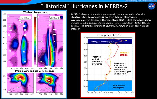
The focus of this slide is on the infamous category-5 Hurricane David, which occurred in 1979. The plots show the structure of the storm when it was at its peak intensity (1200 UTC 30 August). A comparison of its representation in MERRA-2 with MERRA is provided.
The top left panels show vertical cross-sections of wind (m/s) and temperature (°C) across the storm center, to display the "eye" (a virtually windless column in the center) and the warm core (a temperature maximum in the eye). A more compact circulation, a narrower eye, a lower height of maximum wind, and a more pronounced warm core are all evident in MERRA-2 compared to MERRA. These features all indicate the Hurricane David is represented more realistically in MERRA-2. The bottom left panels show sea-level pressure and wind speed at 900 hPa, again emphasizing the enhanced structure of the storm in MERRA-2.
In the right-hand figure, the vertical structure of area-averaged divergence (in 10-5/s) is computed in a 4°x4° box centered on the storm. In a mature, "perfect" hurricane, all the convergence should be confined below 800 hPa, and all the divergence between 200 hPa and the tropopause. Divergence in the mid levels should be very small. The orange line shows that the divergence profile computed from MERRA-2 is much improved with respect to MERRA, indicating a more realistic representation of the storm structure.
Similar results are obtained when investigating the structure of a number of infamous "historical" hurricanes such as Frederic (1979), Allen (1980) and others in the 1980s.


