

Meteorologic Analysis of the August 2023 Maui Wildfires
The August 8th-9th wildfires in Hawaii devastated the island of Maui, resulting in the United States' deadliest wildfire in the last 100 years. The Lahaina and Upcountry fires caused widespread destruction and loss of life, predominantly in the town of Lahaina. The start of the fires, in particular the Lahaina fire, was speculated to have been downed power lines, which sparked and ignited dried vegetation in areas experiencing moderate (D1) to severe (D2) drought conditions, according to NOAA.
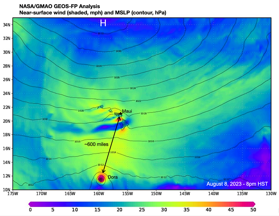
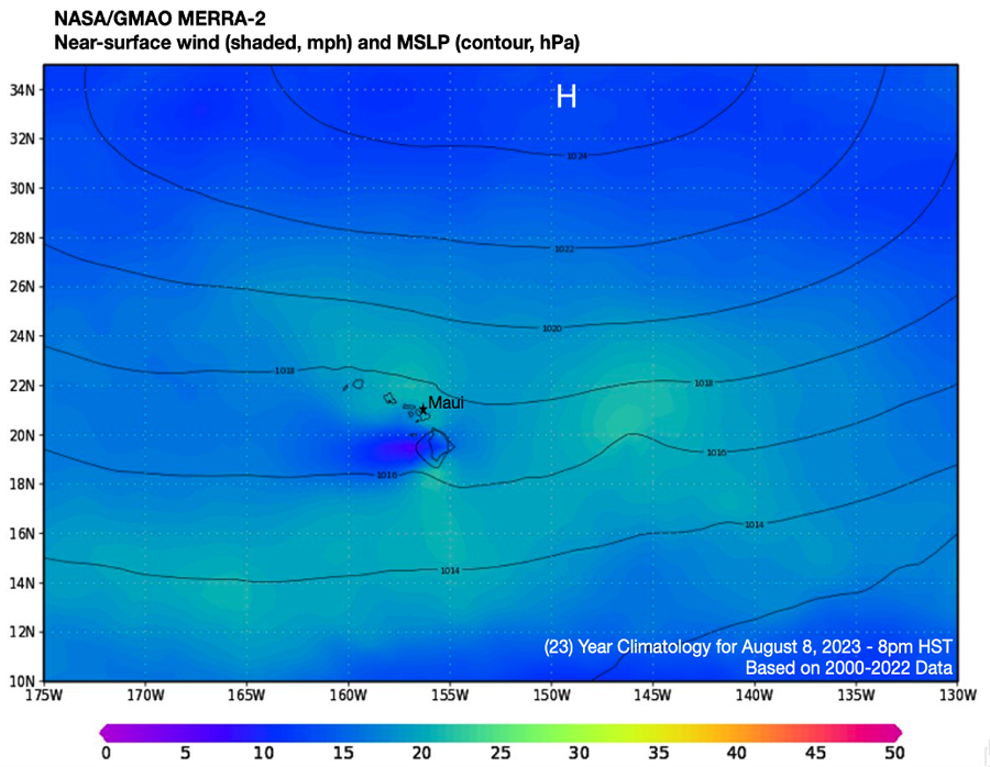
The meteorology leading to the unusually high regional winds over the Hawaiian Islands was straight-forward. Synoptically, an anomalously strong high-pressure system for the time of year was situated northwest of the state, analyzed at 1034 hPa with the NASA Global Modeling and Data Assimilation Office’s (GMAO) Goddard Earth Observing System (GEOS) on August 8th at 8pm Hawaiian Standard Time (HST). Analyzing a 23-year period using MERRA-2 (Modern-Era Retrospective analysis for Research and Applications, Version 2) data from the GMAO, it is apparent the normal subtropical high pressure in this region is both centered more south-southeast and roughly 10 hPa weaker than the high analyzed at 8pm locally on August 8th, 2023. The strength and position of this high pressure both increased the background winds over the wider region (Figs. 1a, 1b), and subtly shifted the wind direction to due easterly. This setup induced efficient, katabatic winds down the west side of Pu’u Kukui Mountain in western Maui, accelerating through gaps in the terrain of the area. Both the katabatic downslope and terrain gap funneling effects combined to drastically dry and accelerate the winds even further beyond the 20-30 mph background flow. This set up western Maui’s coastal communities to be within a focused target zone of dramatically higher, local scale winds; in some instances, winds were doubled or even tripled. The region that saw these conditions was also experiencing a heightened, antecedent drought, providing an ample fuel source for the fires.
It is worth noting that Category 4 Hurricane Dora was tracking westward to the south of Hawaii during the time of the wildfires. Dora was a notably long-lived, intense hurricane for this region of the Pacific Ocean, however, the hurricane played virtually no role in the western Maui winds and subsequent firestorm. The distance between Maui and Dora – approximately 600 miles – was too great for there to be any meaningful influence on the synoptic, gradient, or local scales that contributed to the fires. The high-pressure system north of Hawaii noted as the primary cause, in fact, forced the hurricane on its atypical, equatorward trajectory. This more southerly track allowed Dora to remain over higher SST and a lower-shear environment than it would typically encounter had it moved further north and closer to Hawaii, allowing it to maintain its strong intensity. This distance, though, prevented Hurricane Dora from being a factor on the tragic fires in west Maui.
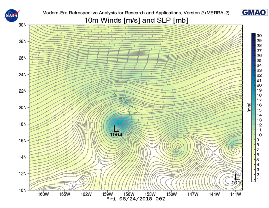
Interestingly, the same region saw a wildfire in 2018, with similar conditions preceding it: drought conditions in Maui, a ridge to the north, and a hurricane to the south were all present. However, unlike the pattern from the August 8th fires, the hurricane at that time (Hurricane Lane) was, in fact, close enough to the state to contribute to the winds which spread the fire (Figure 2a). Luckily, the 2018 fire was able to be controlled before it got to a similar level as 2023, helped in part by rain from the same hurricane. That was not the case for the fires this year.
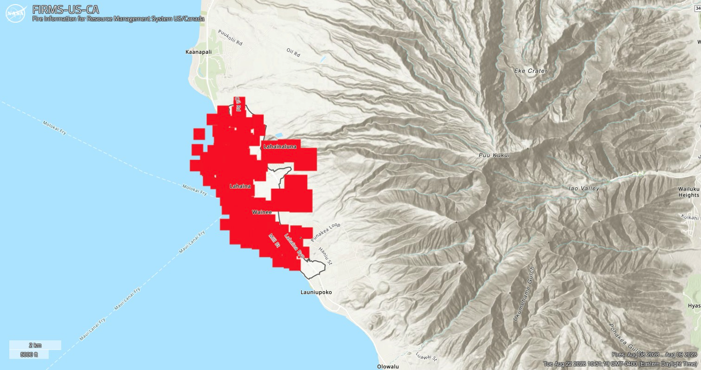
Adding to the severity of the Lahaina fire were the location where the blaze started, and the timing of the fire. After the initial fire which started around 6:45 am HST on August 8th was extinguished in a couple hours, the fire reignited east of the town around 3:30 pm and grew rapidly, due to the conditions previously discussed. Lahaina sits on the west coast of Maui, and with winds blowing out of the east and the town just west of the fire, the town of 12,000 was right in a direct path as the wildfire spread. Some individuals unable to evacuate in time resorted to sheltering in the ocean, as the fire raged overnight and into early morning of August 9th. The flames would not be 100% contained until August 10th. Figure 3 shows the burned area of the town. Pu’U Kukui Mountain, responsible for the katabatic tunnel effects of the winds which spread the fire so rapidly, is seen to the east.
References
"Lahaina Fire Flareup Forces Lahaina Bypass Road Closure; Shelter in Place Encouraged". Maui County, Available at https://www.mauicounty.gov/CivicAlerts.aspx?AID=12632 Accessed 29 Sept. 2023.
Map Archive | U.S. Drought Monitor. , Available at https://droughtmonitor.unl.edu/Maps/MapArchive.aspx Accessed 29 Sept. 2023.
NASA-FIRMS, Available at https://firms.modaps.eosdis.nasa.gov/map/ Accessed 29 Sept. 2023.