

A 3D View of an Atmospheric River from an Earth System Model
Lead Visualizer: Greg Shirah; Lead Producer: Jefferson Beck
Atmospheric rivers, or long and narrow transient corridors of strong horizontal water vapor transport, play an important role in Earth’s hydrologic cycle and are responsible for most of the poleward transport of atmospheric moisture. Along the west coast of the United States, atmospheric rivers provide valuable freshwater resources but can also be destructive through extreme precipitation events that result in flooding and mudslides. A new animation produced by NASA’s Scientific Visualization Studio demonstrates a 3-dimensional view of an intense atmospheric river that impacted the Pacific Northwest in December 2010. This was made possible using the MERRA-2 reanalysis, a spatially and temporally consistent blend of satellite and conventional observations with a numerical model that provides hourly data spanning over four decades.
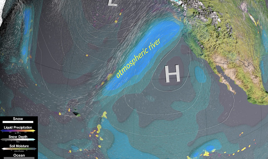
A common measure for the strength of an atmospheric river is the integrated water vapor transport, or the amount of moisture that is moved from one place to another by the flow of the atmosphere. The blue shading shown here gives a three-dimensional view of the water vapor transport. Tropical moisture is pulled in from the Intertropical Convergence Zone (ITCZ) and in this example, converges with other moisture sources to form an atmospheric river. The feature then travels towards the west coast of the United States as a sub-class of atmospheric rivers commonly referred to as the “pineapple express” due to its origin near Hawai’i.
The atmospheric river is guided by the semi-permanent sub-tropical high pressure off the coast of California and the Baja Peninsula as well as the Aleutian low in the Gulf of Alaska. The pressure gradient between the clockwise flow of the Californian high and the counterclockwise flow of the Aleutian low funnel the atmospheric moisture into a narrow corridor. The more intense the pressure gradient is, the stronger the winds are that transport the water vapor.
Much of the moisture stays close to the surface but the rising motion of the low pressure to the north results in the air cooling, condensing the water vapor into a liquid. Precipitation over the ocean falls along the feature’s cold front on its northern side.
Another way that air can rise and condense into precipitation is through orographic lift. When air encounters the mountains along the west coast of the United States, it is forced upwards. The rising air becomes saturated, causing rain and snow to fall, particularly on the windward side of the mountain. The flow of air continues eastward, depleted of its moisture.
Atmospheric rivers are not unique to the west coast of North America and occur around the globe, including Europe, New Zealand, the Middle East, Greenland, and Antarctica. GMAO’s MERRA-2 is an invaluable tool for studying global atmospheric phenomena such as atmospheric rivers. With a dataset that provides hourly information around the globe since 1980, there is still much that can be learned about Earth’s atmosphere and the transport of water and energy around the globe.