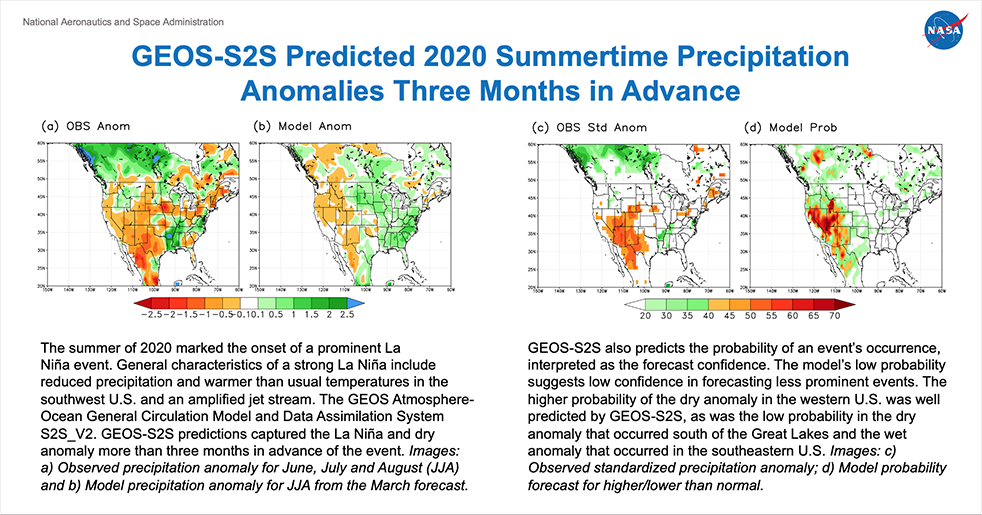
GEOS-S2S Predicted 2020 Summertime Precipitation Anomalies Three Months in Advance
In 2020, the La Niña event led to drier and warmer conditions in much of the western U.S. and south of the Great Lakes, and wetter in the southeast.
GMAO's seasonal forecasts are produced with the Global Earth Observing System (GEOS) Atmosphere-Ocean General Circulation Model and Data Assimilation System S2S_V2.The GEOS-S2S-V2 system forecasted a persistent negative precipitation anomaly on the west coast three months ahead of time and with high probability (present in most of the ensemble forecast members). The GEOS-S2S-V2 forecast system predicted the La Niña and the associated drought in summer much earlier than majority of the National MultiModel Ensemble (NMME) models.

The GEOS mean forecast did not properly predict the dry conditions in the Ohio River Valley and underestimated the wet conditions in the Louisiana, Mississippi and Arkansas area. However, the ensemble spread resulted in lower probability forecasts in those regions, and the observed anomaly was also of lower probability than the conditions in the southwest. This error could suggest challenges in predicting the location and amplitude of the jet stream over the eastern U.S. at these long lead times.
In addition to forecasting the precipitation (or temperature) anomaly, GEOS-S2S also predicts the probability of an event's occurrence, which is interpreted as the confidence in the forecast. The model's low probability suggests low confidence in forecasting these less prominent events. The higher probability of the dry anomaly in the western U.S. was well predicted by GEOS-S2S, as was the low probability or confidence in the dry anomaly that occurred south of the Great Lakes and the wet anomaly that occurred in the southeastern U.S.


