
GEOS Captures Tropical Cyclone-Like System “Trudy” over the Mediterranean Sea
The NASA GEOS Forward Processing (FP) system has now advanced far enough to analyze and forecast a particular kind of cyclone that was otherwise purely theoretical in models just five years ago. This cyclone type is found primarily in the Mediterranean Sea and is thus frequently referred to as a “Medicane”. With hybrid tropical and mid-latitude characteristics, the Medicane has been known and observed for quite some time, but only now can be resolved in our more sophisticated high-resolution data assimilation models. Forecasting these cyclones accurately has significant societal impact, as some of the more severe storms in this class have been known to unleash winds of 50m/s, or more!
In this case study, we evaluate the FP forecast and analyses of Medicane “Trudy” (these storms are given people’s names much as their tropical cyclone cousins, in order to distinguish one from another for historical purposes). Trudy, like many of its Medicane predecessors, was not particularly long lived, forming rather rapidly on 11 November 2019 and coming ashore the Algerian coast of North Africa later the same day, where it then dissipated.
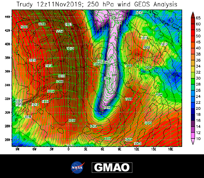
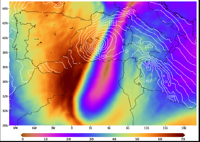
"Medicanes" are a type of short-lived but intense cyclone that form over the Mediterranean Sea. This case study of Medicane Trudy, which made landfall in northeastern Algeria on 11 November 2019, demonstrates that the GEOS Forward Processing (FP) system is able to analyze and forecast such cyclones. The figure shows the GEOS analysis of upper tropospheric wind and sea level pressure at 1200 UTC on 11 November 2019. The streamlines show a sharp southerly meander of the jet stream, with strong horizontal shear on its western side. The wind speeds in this region change from 65 ms-1 to less than 10 ms-1 over a distance of only 250 km.
While not exceedingly rare, the Medicane cyclone occurs on average once per year or every other year. They most frequently form in the autumn, probably owing to the right combination of relatively warm SSTs and increasing dynamical jet energy. Their typical scales are 100-300km in diameter, 25-50m/s of wind strength, and a lifespan of one-half to two days. These systems are fueled by strong Mediterranean Sea fluxes, often greater than 500W/m2 with a dominant role played by deep convection. A particularly sharp horizontal (east-to-west) velocity gradient at jet stream level is often situated directly above an embryonic surface low pressure system. Through barotropic instability, a vortex at jet level is able to propagate down to the surface further intensifying the circulation. With strong ocean fluxes at the surface through convection, the feedback loop is primed for continued cyclogenesis.
A particularly long-lasting Medicane occurred between 6-10 October 1996 and was described in detail by Reale and Atlas (2001). The Medicane dissipates when it reaches land, and in the tight confines of the Mediterranean Sea, it usually finds itself on land fairly soon.
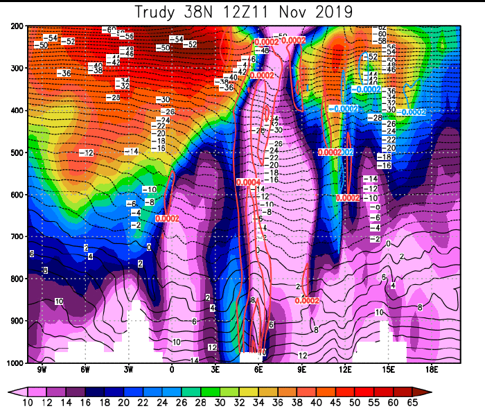
A vertically-aligned column of vorticity provides a dynamic connection between the lower troposphere and the jet stream. (Vorticity, s-1, red contour; wind, ms-1, shaded; and temperature; °C, black contour)

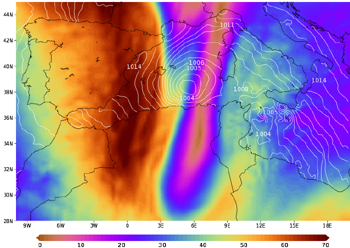
The intense heat fluxes are typical of those associated with tropical cyclones, though landfall quickly stops the cyclone from developing further. (Latent+Sensible Heat Fluxes, Wm-2, shaded; and 2m wind, ms-1)
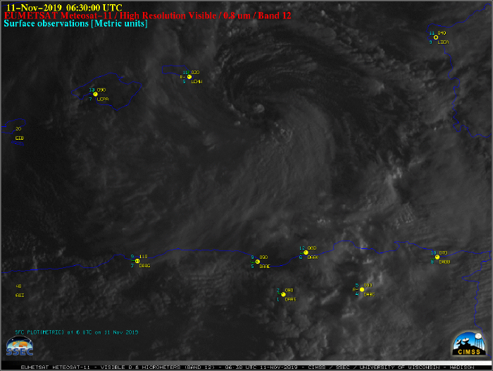
Meteosat-11 visible-spectrum imagery of Medicane Trudy on 11 November 2019.
Until now our models could not fully resolve these processes. But the current GEOS FP did show all the ingredients necessary to trigger Trudy. This appears to be the first Mediterranean Medicane correctly forecast and analyzed in historical NASA GEOS terms.
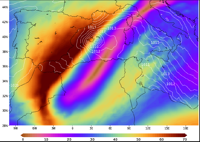
GEOS-FP provided skillful forecasts of Medicane Trudy more than three days in advance, including development of the strong upper-level wind shear and other key features that gave rise to the cyclone. Of particular use to forecasters is that GEOS FP consistently placed the surface low pressure center directly beneath the gradient of upper level wind shear and accurately predicted the storm’s intensity and horizontal extent. This consistency is evident in the 36-, 60- and 84-hr forecasts shown below, notwithstanding the more northeastward tilt of the jet stream meander at the longer forecast lead times. The analyzed (verification) fields for 1200 UTC 11 Nov 2019 were shown previously. (GEOS-FP forecasts of 250 hPa wind, ms-1, shaded; and sea-level pressure, hPa, contour, valid 1200 UTC 11 Nov 2019)
References:
Reale, O. and R. Atlas, 2001: Tropical Cyclones in the Extratropics: observational evidence and synoptic analysis. Weather & Forecasting, 16, 7-34, DOI:10.1175/1520-0434(2001)016<0007:TCLVIT>2.0.CO;2.
Emanuel, K., 2003: Tropical Cyclones. Ann. Rev. Earth Planet. Sci., 31, 75-104, DOI:10.1146/annurev.earth.31.100901.141259.