
Long-Term Improvements of GEOS-FP Forecast Skill
The GMAO's "Global Earth Observing System – Forward Processing" (GEOS-FP) undergoes frequent upgrades to incorporate the latest developments in the GEOS atmospheric general circulation model and data assimilation components. These two panels show how a decade of continuous developments contributed to significant improvements in the forecast skills of the GEOS-FP product. The 10-year time series of root mean square error (RMSE) of 48-hour forecasts, sampled regularly, and self-verified, is shown here for global temperature at 700 hPa (left) and global zonal wind at 250 hPa (right). The GEOS-FP in blue is compared with two operational centers’ products, the National Centers for Environmental Prediction (NCEP) and the European Centre for Medium-range Weather Forecasts (ECMWF) shown in gray and black, respectively.
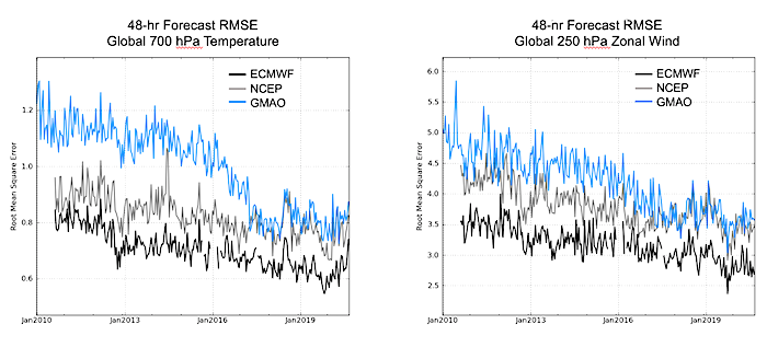
The 10-year time series of the root mean square error (RMSE) of 48-hour forecasts, sampled regularly, and self-verified of global temperature at 700 hPa (left) and global zonal wind at 250 hPa (right) are shown. The GEOS-FP in blue is compared with NCEP and ECMWF operational products (gray and black, respectively).
» Click for PDF «
The narrowing of the gap between GMAO and the other centers over this ten-year period reflects the compounded effect of the small changes that make up each new upgrade. The ensemble 3D-Var data assimilation scheme was introduced in mid-2015 to replace a long-serving conventional 3D-Var system. The hybrid ensemble-variational 4D-EnVar technique, along with an increase in spatial resolution to 12.5km, were adopted in early 2017. Other expanded capabilities included the assimilation of newer radiance observations and the introduction of all-sky data assimilation in mid-2018. The model physics components underwent significant updates with the introduction of the RRTMG longwave and shortwave radiation scheme and various enhancements in model moist parametrizations such as the implementation of the Grell-Freitas scale-aware deep convection scheme combined with the Park and Bretherton shallow scheme. Most recently, the Catchment land model now includes updated hydrology features (soil textures and vegetation phenology and improved physical treatments of soil moisture diffusion and surface thermodynamics) making the GEOS systems consistent with the operational GMAO production of SMAP Level 4 soil moisture products.
For reference, the two GMAO multi-decade products, the MERRA-2 reanalysis and GEOS-FPIT product, use a fixed version of the GEOS system that is comparable to the one that was available in 2014. The system changes that lead to these improvements in forecast skill since 2014 are one justification for proceeding to upgrade both of these multi-decadal products using more recent versions of the GEOS system.