
Air Pollutant Forecasts Using the NASA GEOS-CF Model: Global Modeling Assessment of Pollutants During Wildfires
The May and June 2019 wildfires that occurred in Alberta, Canada led to increased smog, which resulted in air quality warnings issued in that region. In one case, the Chuckegg Creek Fire, southwest of High Level, Alberta, burned more than 300,000 hectares and forced thousands of people to evacuate their homes. Smoke from these fires spread to much of the northern tier of the United States, reaching as far South as Colorado, Minnesota, and Kansas, with lighter concentrations in Oklahoma and Arkansas. This led to poor air quality in those areas.
Ozone (O3) is produced and destroyed within the atmosphere through interactions of various chemical compounds such as nitrogen oxides (NOx) and volatile organic compounds (VOCs), both of which are emitted by fires. O3 is not directly emitted from wildfires. Indeed, close to the center of the fires high concentrations of freshly emitted NO consume O3, resulting in low O3 concentrations in immediate proximity to the fires and within the center of the fire plume. However, O3 is produced as the plume mixes with surrounding air masses, causing O3 concentrations to increase above 50 parts per billion (ppbv) at the edge of the fire plume. The increased O3 concentration levels caused by wildfires are comparable to O3 pollution produced in large urban areas.
Wildfires emit a complex mix of gaseous and aerosol pollutants that spread from the initial source region, potentially impacting communities both near and far. Complex chemical interactions occur within these fire plumes, changing the composition of the plumes as they age. NASA’s GEOS Composition Forecast model (GEOS-CF), which includes comprehensive treatment of gas and aerosol phase chemistry, captures these processes, as seen in the above examples of the Alberta, Canada wildfires. Ozone (O3) is shown in the top image and fine particular matter (PM2.5) is shown in the bottom image.
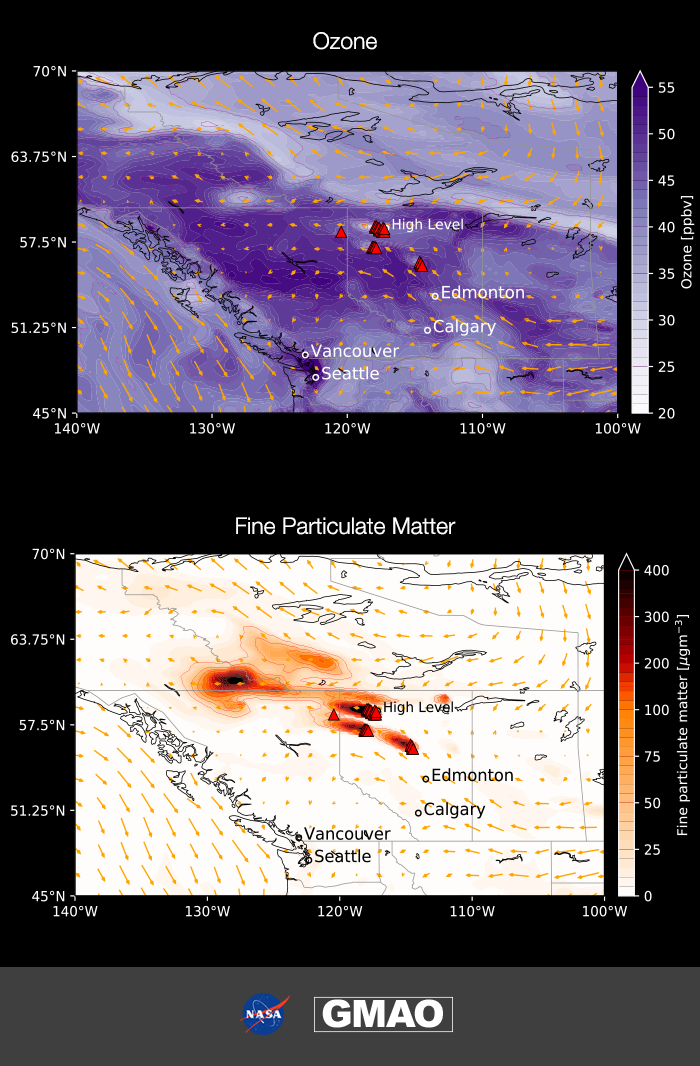
The top image shows the corresponding concentration map of O3. The bottom figure shows the widespread transport of fine particulate matter (PM2.5), a primary pollutant directly emitted from the fires, as simulated by GEOS-CF. PM2.5 tends to get washed out during wildfires resulting in a decrease in concentration with growing distance from the fire plume.
The NASA Goddard Earth Observing System (GEOS) Composition Forecast (GEOS-CF) system has been used to produce near-real time air quality forecasts of atmospheric composition at a high global resolution of 25x25 km2. This model configuration combines the capability of capturing long-range transport in the global model with a spatial resolution that is more typical of regional air pollution models, which is fine enough to capture the signature of localized emissions. The GEOS-CF system utilizes the GEOS weather forecast model coupled with GEOS-Chem (version 12) chemistry module to provide detailed chemical analysis of a wide range of air pollutants such as O3, NOx, and fine particulate matter (i.e., PM2.5). GEOS-CF can be used to perform analysis and predictions for pollutant concentrations during wildfires and other severe air quality events.
GEOS-CF was able to simulate in near real-time how these fires impacted the change in pollutant concentrations by using satellite observations to constrain fire emissions (i.e., the Quick fire emissions dataset [QFED]). QFED uses satellite observations of fire radiative power (FRP), a measure of the rate of radiant heat output from a fire (Wooster et al., 2005), to estimate gridded fire emissions globally. The location and FRP of the fires are obtained from the MODIS satellite. QFED provides biomass burning emissions of several gases and aerosols (i.e., NOx, PM2.5, VOCs, etc.) and is produced daily at a high spatial and temporal resolution at near-real time (Darmenov and da Silva, 2015). GEOS-CF incorporation of the QFED emissions allowed it to demonstrate the impact fires have on these pollutants due to the lifetime of these species and the chemical reactions that occur between NOx and VOCs, which both produce and titrate O3. Air quality can vary dramatically by region during wildfires and the GEOS-CF system offers a new tool for scientists and the public health community to produce global insights into these regional events.
GMAO GEOS-CF Simulation: https://gmao.gsfc.nasa.gov/research/science_snapshots/anim/air_pollution_GEOS-CF.mp4
The May and June 2019 wildfires that occurred in Alberta, Canada led to increased smog, which resulted in air quality warnings issued in that region. GEOS-CF was able to simulate in near real-time how these fires impacted the change in pollutant concentrations by using satellite observations to constrain fire emissions. Air quality can vary dramatically by region during wildfires and the GEOS-CF system offers a new tool for scientists and the public health community to produce global insights into these regional events.
References
Darmenov, A. S., A.d. Silva, 2015: The Quick fire emissions dataset (QFED): documentation of versions 2.1, 2.2 and 2.4. Technical Report Series on Global Modeling and Data Assimilation, NASA, R.D. Koster (Ed.), p. 212 Document
Wooster, M. J., G. Roberts, G. L. W. Perry, and Y. J. Kaufman, 2005: Retrieval of biomass combustion rates and totals from fire radiative power observations: FRP derivation and calibration relationships between biomass consumption and fire radiative energy release. J. Geophys. Res., 110. doi: 10.1029/2005JD006318.