
Global Assessment of Added Value in the SMAP Level-4 Soil Moisture Product
The NASA Soil Moisture Active Passive (SMAP) Level-4 Soil Moisture (L4SM) product merges SMAP brightness temperature observations with simulations of the Goddard Earth Observing System (GEOS) Catchment land surface model. The L4SM product has been directly validated against measurements from dense in situ networks and was shown to outperform the land model simulations (Reichle et al., 2017, 2019). However, these assessments were mostly limited to data‐rich areas, including the United States and Europe.
Dong et al. (2019) present a novel approach to quantify the relative skill of SMAP L4SM and land model-only surface soil moisture estimates with the help of noisy but independent satellite retrievals. Using soil moisture retrievals from the Advanced Scatterometer (ASCAT), the approach was first verified where in situ measurements are available and then applied globally
Previous L4SM assessments vs. in situ measurements focused on data-rich regions such as the U.S. and Europe and therefore underestimated the contribution of SMAP data assimilation.
SMAP L4SM skill relative to that of a model-only simulation. Red shading indicates areas where L4SM has improved surface soil moisture skill with respect to a land model-only baseline.
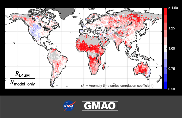
Results indicate that SMAP assimilation provides relatively little added skill in precipitation data‐rich regions (including the United States and Europe), but much larger added value in precipitation data‐sparse regions (including much of Africa and central Australia). Therefore, previous assessments of SMAP L4SM performance using in situ measurements underestimated the true global contribution of SMAP data assimilation.
It is further demonstrated that SMAP data assimilation provides relatively more added value in lightly vegetated areas, which is consistent with the known limitations of microwave soil moisture remote sensing over densely vegetated areas
Abbreviations
- ASCAT: Advanced Scatterometer [satellite sensor]
- GEOS: Goddard Earth Observing System [modeling and assimilation framework]
- L4_SM: Level-4 Soil Moisture [data product]
- SMAP: Soil Moisture Active Passive [satellite mission]
References:
Dong, J., W. Crow, R. H. Reichle, Q. Liu, F. Lei, and M. H. Cosh (2019), A Global Assessment of Added Value in the SMAP Level 4 Soil Moisture Product Relative to Its Baseline Land Surface Model, Geophys. Res. Lett., 46, 6604-6613, doi:10.1029/2019GL083398.
Reichle, R. H., and Coauthors (2017), Assessment of the SMAP Level-4 Surface and Root-Zone Soil Moisture Product Using In Situ Measurements, J. Hydromet., 18, 2621-2645, doi:10.1175/JHM-D-17-0063.1.
Reichle, R. H., and Coauthors (2019), Version 4 of the SMAP Level-4 Soil Moisture Algorithm and Data Product, J. Adv. Mod. Earth Sys., in press, doi:10.1029/2019MS001729.