
Joint Assimilation of SMOS brightness Temperature and GRACE Terrestrial Water Storage Observations
Accurate vertical profile soil moisture estimation is crucial to the quality of most water-related environmental, weather and climate forecasts. Soil moisture controls the exchange of water and energy between the land surface and the atmosphere through evaporation and plant transpiration. Because soil moisture varies greatly in time and space, including in the vertical dimension, estimating profile soil moisture at regional to global scales remains a major challenge. This work aims at improving model estimates of the vertical soil moisture profile via assimilation of multi-resolution, multi-sensor satellite observations.
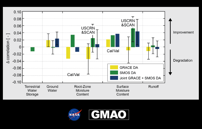
The graph shown in this Snapshot depicts the impact of assimilating Gravity Recovery and Climate Experiment (GRACE) terrestrial water storage (TWS) data, Soil Moisture and Ocean Salinity (SMOS) brightness temperature data, and both data types on the skill of a hydrological model (Girotto et al., in preparation).
The assimilated GRACE observations are monthly TWS estimates at about 300-400 km spatial resolution from the level-3 spherical harmonics product published by the Center for Space Research at the University of Texas (for details, see Girotto et al., 2016). The assimilated SMOS observations are microwave brightness temperatures at an incidence angle of 40 degrees that have a spatial resolution of 43 km and provide global coverage approximately every 3 days (for details, see De Lannoy and Reichle, 2016a,b). The SMOS brightness temperatures are sensitive to soil moisture and temperature in the top few centimeters of the soil. We use the Catchment Land surface model (CLSM; Koster et al., 2000), which is the land surface model of Goddard Earth Observing System (GEOS) model, together with a “tau-omega” microwave radiative transfer model in order to predict the brightness temperatures that are observed by SMOS (De Lannoy et al., 2013).
Both SMOS and GRACE observations are bias-corrected prior to assimilation, and only the anomalies are assimilated; that is, the SMOS observations are scaled to match the long-term mean seasonal cycle of the modeled brightness temperatures, and the GRACE observations are likewise scaled to the long-term mean and standard deviation of the modeled TWS. The bias correction was necessary to assimilate the observations in a bias-free environment. In this Snapshot, “skill” is defined as the difference in the temporal correlation coefficient between the model-only simulation and the assimilation experiments.
The GRACE assimilation mostly improves groundwater estimates, and (by construction) TWS. The SMOS assimilation improves surface soil moisture, and, marginally, rootzone soil moisture. When both observation types are assimilated together within a joint assimilation system, most of the benefits of assimilating each observation type independently are maintained (i.e., improved groundwater, terrestrial water storage, and surface soil moisture).
TWS is defined as the total column of water, that is, the sum of groundwater, rootzone and surface soil moisture, snow, and water stored in lakes, rivers, and the vegetation canopy. Surface soil moisture is defined as the amount of water in the 0–5 cm surface soil layer. Rootzone soil moisture is defined as the amount of water in the 0–100 cm “rootzone” soil layer. Groundwater is defined as the first unconfined saturated water storage.
References:
De Lannoy, G. J., Reichle, R. H., & Pauwels, V. R. (2013). Global calibration of the GEOS-5 L-band microwave radiative transfer model over nonfrozen land using SMOS observations. Journal of Hydrometeorology, 14(3), 765–785, doi: 10.1175/JHM-D-12-092.1.
De Lannoy, G. J., and Reichle, R. H. (2016a). Global assimilation of multiangle and multipolarization SMOS brightness temperature observations into the GEOS-5 catchment land surface model for soil moisture estimation. Journal of Hydrometeorology, 17(2), 669-691, doi:10.1175/JHM-D-15-0037.1.
De Lannoy, G. J., & Reichle, R. H. (2016b). Assimilation of SMOS brightness temperatures or soil moisture retrievals into a land surface model. Hydrology and Earth System Sciences, 20(12), 4895, doi:10.5194/hess-20-4895-2016.
Girotto M., R. H. Reichle, G. J. De Lannoy, M. Rodell. Multi-variate Assimilation of SMOS Brightness Temperature and GRACE Terrestrial Water Storage Observations for Soil Moisture and Shallow Groundwater Estimation, in preparation for submission to Remote Sensing of the Environment.
Girotto, M., G. J. De Lannoy, R. H. Reichle, and M. Rodell. (2016). Assimilation of gridded terrestrial water storage observations from GRACE into a Land Surface Model, Water Resources Research, doi:10.1002/2015wr018417.
Koster, R. D., Suarez, M. J., Ducharne, A., Stieglitz, M., & Kumar, P. (2000). A catchment-based approach to modeling land surface processes in a general circulation model: 1. Model structure. Journal of Geophysical Research: Atmospheres, 105(D20), 24809–24822, doi:10.1029/2000JD900327.