
Validation of Aquarius and SMAP Sea Surface Salinity in the Tropics
Sea Surface Salinity (SSS) can help to identify the ocean-surface signature of large-scale changes in the hydrological cycle. One example of such a phenomenon is the changes associated with El Niño/Southern Oscillation (ENSO). Using data retrieved from NASA’s Aquarius and Soil Moisture Active/Passive (SMAP) satellites, we can now map global salinity patterns to help scientists better understand the water cycle and its link to climate variations and change, potentially leading to improvements in these processes in the models used to predict seasonal circulation anomalies and longer term changes in the oceans and atmosphere.
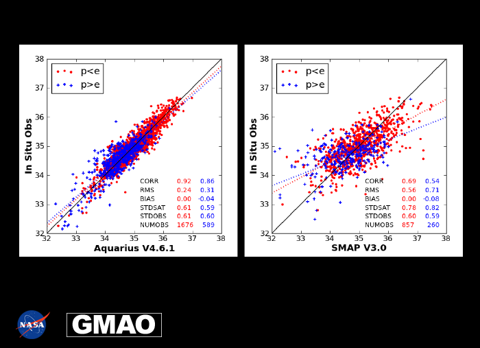
In collaboration with NASA’s Ocean Salinity Science Team, the latest versions of Aquarius and SMAP SSS data are being validated. The Aquarium Mission provided observations from September 2011 until June 2015; SMAP began operations in March 2015. Assessing the two data sets together allows researchers to determine if Aquarius and SMAP can be combined to produce a longer time series for use as an SSS climate data record. In this work, the most recent versions of the along-track (Level 2) Aquarius (Version 4.6.1) and SMAP (Version 3.0) SSS retrievals are evaluated against in-situ observations from the National Oceanographic Data Center (NODC) Global Temperature and Salinity Profile Programme (GTSPP). The satellite data uses all standard quality control except for the rain flag. The GTSPP data are made up of the “best” quality-controlled version and contains Argo, CTD, XBT, TAO, PIRATA, and RAMA profiles. Data are validated for Aquarius from August 2011 to June 2015 and for SMAP from March 2015 to April 2017, and the overlap period of the two satellites is from March to June 2015. Matchups are created from in situ observations on the same day and within 1o radius of the satellite data.
Level-2 Sea-Surface Salinity (SSS) retrievals from Aquarius (Version 4.6.1) and SMAP (Version 3.0) are evaluated. They are compared with in-situ observations. Evaporation (E) and precipitation (P) fields from MERRA-2 are used to delineate between well mixed (red) and rainy (blue) regions. Results are shown for the Tropical Pacific Ocean.
The main features are:
- SSS and in-situ data agree quite well when evaporation dominates – in these conditions the upper ocean is well mixed;
- Agreement is not as good when precipitation dominates – in this case there is a thin layer of fresh water above a well-mixed layer, so the SSS is expected to diverge from the in-situ data from ~5 meters below the surface; and
- SSS estimated from SMAP V3.0 retrievals is of lower quality than Aquarius V4.6.1, showing opportunities for further algorithm developments.
» Click for PDF «
A unique aspect of this work is that point-wise, in-situ observations are utilized rather than gridded products, so the errors inherent in gridded salinity data do not contaminate our results. In situ measurements for collocations are limited to the shallowest (not deeper than 10m) observation. However, a majority of the in situ data come from Argo buoys which typically observe salinity at a depth of ~5 m whereas the satellite SSS is a surface observation (~1 cm depth).
The comparison of satellite SSS with in-situ measurements is performed for both rainy and well-mixed ocean conditions by using information on Evaporation (E) and Precipitation (P) from the GMAO’s MERRA-2 reanalysis. The P and E fields from MERRA-2 allow the comparison to be delineated into two regimes, where P > E and P < E. In rainy locations (P > E) there is a net flux of fresh water to the ocean surface that is not quickly mixed to lower levels, so that a vertical gradient in salinity exists and agreement between the SSS values for the upper 1cm of the ocean and likely to differ from the salinity at a depth of around 5m. In conditions when E > P it is expected that the upper ocean remains well mixed and a better agreement is expected between the in-situ and space-based measurements.