
High-Resolution Global Modeling of Atmospheric Chemical Composition
Air pollutants such as ozone (O3), nitrogen oxides (NOx), carbon monoxide (CO), and particular matter (PM) are the result of complex, interacting processes. Computer models are an essential tool used to understand, predict, and inform mitigation of the detrimental effects of air pollution on agriculture, the environmental and public health. NASA’s Global Modeling & Assimilation Office (GMAO) Goddard Earth Observing System (GEOS) system has been extended to include a state-of-the-art model of atmospheric chemical composition, giving scientists at GMAO a global model of atmospheric composition that can be run with unprecedented horizontal resolution.
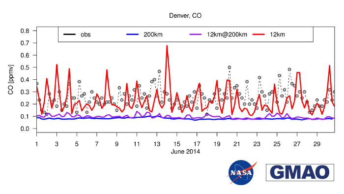
Air pollution can be highly heterogeneous, especially near densely populated areas or complex terrain. High-resolution models are needed to capture these spatial heterogeneities. An example of carbon monoxide in Denver, Colorado is used as an illustration. In the figure, the grey dots are concentrations of carbon monoxide measured by the Environmental Protection Agency’s (EPA) Air Quality System (AQS). The red line shows the surface CO in the new high-resolution (about 12km) simulation with the GEOS model, while the blue line is from a simulation at a lower resolution (about 200km). The image also shows the impact of averaging the 12-km model to the 200-km model grid: the purple curve is almost coincident with the blue one. The main deduction from this is that when global models that include atmospheric chemistry are run at scales that adequately represent the local topography, then the time variations and pockets of extremely high local values of air pollution can be represented. This is not the case when model simulations capture only the largest spatial scales. However, at low resolution the model does provide a simulation of surface air pollution that is consistent with the average structure captured in the high-resolution simulation.
The high-resolution simulation was performed at so-called “c720 resolution” – that is, where each face of the cubed-sphere grid used in the GEOS model is gridded with an array of 720 by 720 points. It corresponds to a edge length of about 12km, which is currently used in the GMAO’s “weather analysis” system (GEOS FP). The low resolution has a c48 resolution, corresponding to about 200km, which is typical of scales used in current chemistry-transport models (CTMs). These results thus demonstrate some of the enhanced possibilities for representing atmospheric pollution in weather models as compared to typical global chemical models.
GMAO’s GEOS model of atmospheric composition offers a new tool for scientists and the public health community. This new model gives GMAO the capacity to model the small-scale features relevant for air quality. Scientists at GMAO are currently using this model to develop a forecast system of atmospheric composition.