
SMAP Soil Moisture Skillful in Determining Subsequent Streamflow
Knowing the amount of moisture stored in the soil before a rain event can aid in the prediction of the resulting streamflow and flash flood potential. Suitable soil moisture estimates are available globally from the NASA Soil Moisture Active Passive (SMAP) mission and the ESA Soil Moisture Ocean Salinity (SMOS) mission.
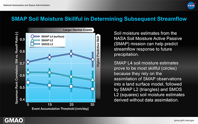
The potential for predictive skill is shown on the y-axis of the figure. This skill is measured by the Spearman rank correlation between pre-storm soil moisture and the subsequent storm-scale runoff ratio (i.e., total streamflow divided by total precipitation), averaged across 16 medium-scale catchments in the south-central US. The x-axis reflects variations in the daily rainfall accumulation threshold required to trigger an “event”, with increasing focus on larger events towards the right.
SMAP Level 4 soil moisture estimates prove to be most skillful (circles) because they rely on the assimilation of SMAP observations into a land surface model, followed by SMAP Level 2 (triangles) and SMOS Level 2 (squares) soil moisture estimates derived without data assimilation.
References
Crow, W. T., et al. (2017), Enhanced Streamflow Prediction Using SMAP Soil Moisture Products, Journal of Hydrometeorology, in preparation.
Entekhabi, D. et al. (2014), SMAP Handbook–Soil Moisture Active Passive: Mapping Soil Moisture and Freeze/Thaw from Space. Pasadena, CA USA: SMAP Project, JPL CL#14-2285, Jet Propulsion Laboratory.
Kerr, Y., et al. (2010), The SMOS Mission: New Tool for Monitoring Key Elements of the Global Water Cycle, Proceedings IEEE, 98, 666–687.
O'Neill, P. E., S. Chan, E. G. Njoku, T. Jackson, and R. Bindlish (2016), SMAP L2 Radiometer Half-Orbit 36 km EASE-Grid Soil Moisture, Version 4. Boulder, Colorado USA: NASA National Snow and Ice Data Center Distributed Active Archive Center. doi: http://dx.doi.org/10.5067/XPJTJT812XFY.
Reichle, R. H., et al. (2016), Soil Moisture Active Passive Mission L4_SM Data Product Assessment (Version 2 Validated Release), NASA GMAO Office Note, No. 12 (Version 1.0), 55pp, National Aeronautics and Space Administration, Goddard Space Flight Center, Greenbelt, Maryland, USA. Available from http://gmao.gsfc.nasa.gov/pubs/.
Reichle, R. H., et al. (2016), SMAP L4 9 km EASE-Grid Surface and Root Zone Soil Moisture Geophysical Data. Version 2. Boulder, Colorado USA: NASA National Snow and Ice Data Center Distributed Active Archive Center. http://dx.doi.org/10.5067/YK70EPDHNF0L.