
TAKING AIR POLLUTION TO THE EXTREME
Agricultural Burning and the Air Over Northern India in 2016
With a population of over 1.3 billion people India can be severely impacted by air pollution episodes. A combination of abundant natural and man-made aerosols, regional topography and winds, increased industrial growth and urbanization, amplified by high population density can result in unhealthy levels of air pollution that can affect millions of people for days and weeks.
In October and November 2016 a large scale air pollution event was observed from NASA EOS satellites. Analysis of MODIS and VIIRS true color images and active fires revealed strong link between the observed heavy air pollution and the crop residue burning in the Punjab region. Agricultural fires offer low-cost solution for farmers to prepare rice fields for the next growing season, however unregulated use of fires on such large scale can have dramatic effect on the air quality.
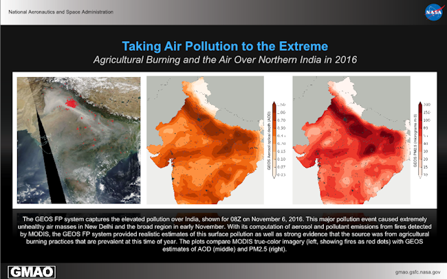
True color images from MODIS/Aqua over India and Pakistan are shown for November 6, 2016 (left panel). The location of the detected fires are marked with red dots. The MODIS imagery shows the smoke from the widespread agricultural fires in Punjab blanketing the North, Central and West India regions. The dry weather conditions and the prevailing continental air allowed smoke from the fires to converge and engulf large parts of the Punjab province in Pakistan.
The transport and extent of smoke from the agricultural fires was reproduced well in the GEOS system. Aerosol optical depth (AOD) and PM2.5 (in micrograms × m-3) from the model are shown respectively in the middle and right panels. The transported downwind of the fires aerosols from the model and the plumes of smoke observed in the true color images have similar spatial structures. The model reproduced the blocking effect of the Tibetan Plateau and the resulting elevated pollution along the base of the plateau. The dense smoke clouds over central India and the outflow of smoke towards the Arabian sea is also evident in the GEOS AOD. In Punjab and in some of the most densely populated Indian states (Haryana, Uttar Pradesh and Bihar) the smoke increased the PM2.5 concentrations to unhealthy levels exceeding 100 micrograms × m-3 indicating that the effect of the agricultural fires worsened the ambient air pollution and was felt by tens of millions of people.