
MERRA-2 Data on a Cube
NASA’s Global Modeling and Assimilation Office (GMAO) performs global modeling and data analysis in conjunction with NASA’s mission of Earth Observation, including space- and aircraft-based observations. The GMAO’s “weather analyses” routinely include aerosols, ozone and carbon monoxide. This is being extended to a more complex chemical suite, with satellite observations of nitrogen dioxide and other pollutants. Data products are provided to the instrument and science teams of NASA’s latest space-based missions, for field campaigns, and forefront modeling studies to support the planning of future missions.
The Modern-Era Retrospective analysis for Research and Applications, Version 2 (MERRA-2) is a product of the GMAO. It is a long-term record of global atmospheric analyses, beginning in 1980. It was introduced to replace the original MERRA dataset because of the advances made in the assimilation system that enable use of modern hyperspectral radiance and microwave observations, among other data types. Additional advances in both the Goddard Earth Observing System (GEOS) model and the Gridpoint Statistical Interpolation (GSI) analysis technique are included. MERRA-2 takes some significant steps toward the GMAO’s target of an Earth System reanalysis. With its assimilation of the long-term observational record of atmospheric aerosols, MERRA-2 is the first long-term global reanalysis to represent aerosol impacts on other physical processes in the climate system. MERRA-2 also includes advances over prior reanalyses in the use of ozone observations and in the representation of cryospheric processes.
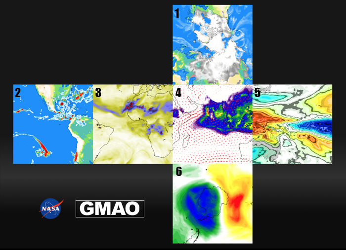
The Modern-Era Retrospective Analysis for Research and Applications, Version 2 (MERRA-2) is the latest atmospheric reanalysis of the modern satellite era produced by NASA’s Global Modeling and Assimilation Office (GMAO). MERRA-2 incorporates observation types not available to its predecessor, MERRA, and includes updates to the Goddard Earth Observing System (GEOS) model and analysis scheme to provide an advanced product suite suitable for weather and climate applications. The six square data images, shown here, illustrate the cubed sphere grid used in the GEOS model that helps improve the representation of the polar regions compared to traditional latitude-longitude grids. On the back of this card are overviews of the six different data sets shown here. For a printable version of the cube, visit gmao.gsfc.nasa.gov/reanalysis/MERRA-2/datacube/GMAO-cube.pdf
» Click for PDF «
Information on Each Data Image:
- ARCTIC
Topography and fraction of area covered by sea ice, snow, and mid-level clouds for October 31, 2016. The diverse north polar region includes an ice-covered ocean, surrounding land regions characterized by a mix of tundra and boreal forests that are seasonally snow-covered, and glaciers ranging in size from small ice caps to the massive Greenland Ice Sheet. The extent of Northern Hemisphere sea ice varies seasonally from an average of 6 million square miles in March to 2.4 million square miles in September. Over the satellite observing period dating to 1979, the September sea ice extent has declined by about 1.3 million square miles. - AMERICAS
Topography and total precipitation for August 28, 2005. Very high precipitation amounts (shown in red) can be seen in Hurricane Katrina located in the Gulf of Mexico. Katrina was responsible for the deaths of over 1,500 people, with damage estimates exceeding 100 billion dollars. North America experiences the world’s most extreme weather with a combination of conditions that can include hurricanes, tornadoes, droughts, floods, wildfires, blizzards, heat waves, and severe storms. Modern reanalyses have improved ability to represent the impact of such extremes, allowing their collective impact to be better understood. - AFRICA
Aerosol optical depth for July 21, 2012. Yellows and greens indicate a lower aerosol optical depth, while blues and reds indicate larger values. Aerosols are minute particles suspended in the atmosphere. Aerosol particles can come from large fires, desert winds, ocean waves, volcanoes, and pollution from urban areas and industrial sources. Sahara Desert dust can be carried aloft across the Atlantic Ocean to the Americas and can even influence the formation and structure of storms. - ASIA
Convective precipitation and 850 hPa (hectopascal) winds for July 2010. Warmer colors indicate more convective precipitation associated with the south Asian monsoon wet season. The size of the arrows indicates wind strength. The windfield highlights the low-level Somali jet, which pushes moist air towards southwestern India. As the largest continent on Earth, Asia covers over 17,200,000 square miles of area with an estimated population of over 4.4 billion people. The monsoon is the main supplier of fresh water to the Indian subcontinent, exerting a strong influence over agricultural production and economic stability for local residents. - PACIFIC
Top-of-atmosphere outgoing longwave radiative flux anomaly for December-February 1982-83. Cooler colors in this image indicate lower than normal values of the longwave radiative flux, and hence more and higher clouds. Warmer colors indicate fewer clouds than average. The Pacific Ocean has a surface area of over 60 million square miles. Year-to-year changes in cloud cover affect the Earth’s energy budget – the balance of shortwave radiation arriving from the sun and longwave radiation emitted by the Earth. Such variations are accompanied by changes in temperature, atmospheric circulation, and rainfall that extend far outside the Pacific. - ANTARCTIC
Total column ozone for August 24, 2002 – an early stage in the development of the 2002 ozone hole. Blues indicate very low column-integrated ozone, while warmer colors indicate larger values. The ozone hole is a seasonal loss of the stratospheric ozone layer over Antarctica, which has occurred annually in the austral spring since the late 1970s. The stratospheric ozone layer protects the Earth's surface from harmful, cancer-causing ultraviolet radiation. Since 2000, the ozone hole area has averaged almost 10 million square miles, or about two and a half times the size of the United States.