
An Icelandic low spins in the North Atlantic
The GEOS model is used to illustrate the role of resolution in representing the cloud field associated with an Icelandic Low in April of 2017. As low pressure systems depart the east coast of the United States they intensify in a region of the North Atlantic near Iceland forming what are known as Icelandic Lows. A variety of clouds types can form within these systems. The size of the grid cells used to simulate the atmosphere in the GEOS model has a significant influence on the types of clouds that can be resolved in these systems. This animation shows the evolution of this Icelandic Low over three days at three different resolutions with the GEOS model: https://gmao.gsfc.nasa.gov/animations/GEOS-Icelandic-Low.php.
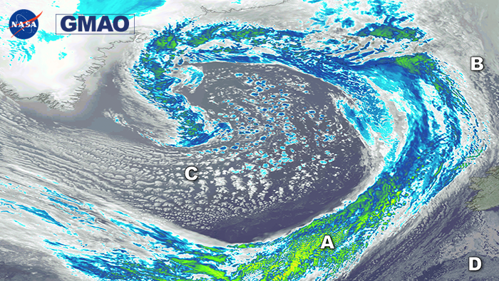
At 50km, typical of high-resolution climate models used for reanalyses like MERRA-2 from GEOS, the deep clouds associated with the frontal system and large-scale structure of the low are well resolved and the parameterizations in the model adequately represent the presence and broad radiative effects of the low clouds ahead of and behind the front. At 12km, the resolution of modern global weather prediction models, the details of these cloud structures begin to appear as smaller clusters of convection within the deep frontal clouds and the low clouds begin to show evidence of their broken nature rather than simply broad regions of thick low clouds. At 1.5km, the resolution of leading edge cloud resolving global models, the GEOS model now explicitly resolves detailed cloud structures within this system including convective clouds within the front and individual stratocumulus cloud clusters behind the front.