GMAO Investigators Andrea Molod, Abdullah Fahad and Atanas Trayanov Members of Proposal Team Selected by the MAP 2023 Program
4.9.2024
GMAO investigators Andrea Molod, Abdullah Fahad, and Atanas Trayanov are members of proposal team - along with others from NASA JPL - selected by the MAP 2023 Program. The following is a summary of the work for which they were selected:
“Because decadal scale variability has a strong influence on many extreme weather events [Liguori and Di Lorenzo, 2018], there is increasing interest in long-range prediction from the agriculture, energy, defense, and maritime sectors [e.g., Carman et al., 2017; Done et al., 2021; Meehl et al., 2021]. For example, prediction of wet and dry climate periods could allow for better water resource management and improved agricultural maintenance, whereas temperature and wind predictions could provide critical information for infrastructure planning and expected energy consumption. The overarching objective of our proposed work is to extend NASA's Global Modeling and Assimilation Office (GMA) seasonal prediction capability to longer lead times through improved understanding, representation, estimation, and prediction of air-sea interactions and of coupled ocean-atmosphere modes of variability.
To achieve this objective, we propose to exploit synergies between two flagship NASA modeling and data assimilation systems, the Goddard Earth Observing System (GEOS), which underlies the work of GMAO, and the Estimating the Circulation and Climate of the Ocean (ECCO) project. This task is made possible by previous work from our proposal team, which incorporated the Massachusetts Institute of Technology general circulation model (MITem), the model at the heart of ECCO, as an alternative, NASA-supported ocean model option within GEOS.
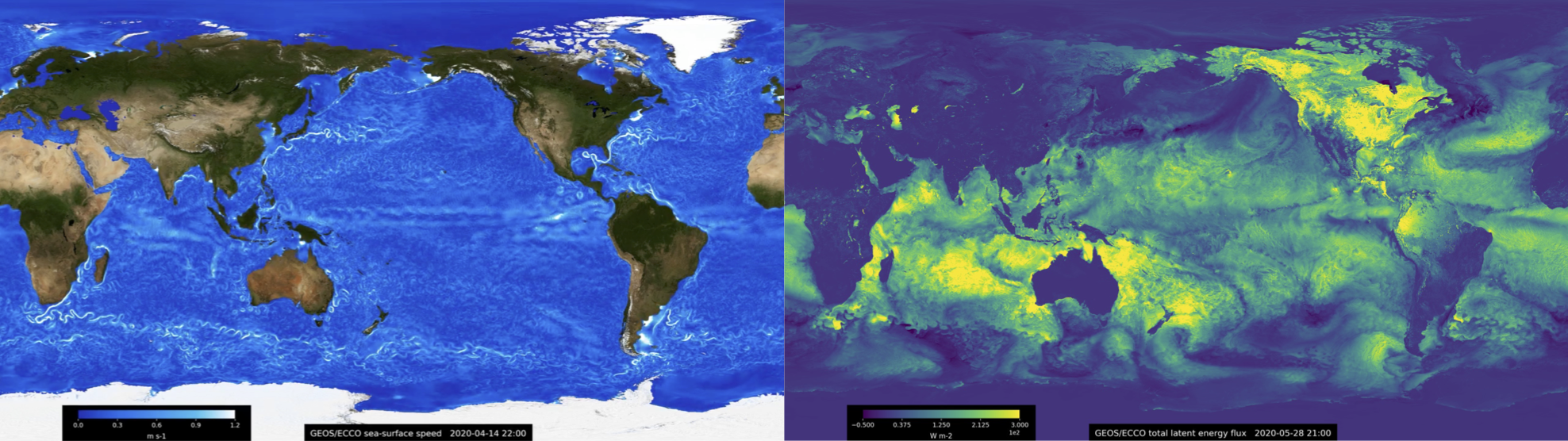
We propose to pursue two research threads, each enabled by unique GEOS and ECCO capabilities. The first set of capabilities pertains to our combined team's experience in integrating global configurations of the GEOS and MITem models at very high resolutions. In particular, team member Trayanov helped set-up GEOS for global cloud-resolving simulations with horizontal grid spacing as small as 1.5 km [Putman et al., 2015]. This was, and remains, one of the highest-resolution simulations carried out with a global atmospheric model. At the same time, as part of the ECCO project, team members Hill, Campin, and Menemenlis have collaborated on a series of ocean simulations that had increasingly higher resolutions [e.g., Menemenlis et al., 2005b; Hill et al., 20071, culminating in a global-ocean simulation with nominal 1/48° horizontal grid spacing that includes tidal forcing [Arbic et al., 2018]. Our team has also carried out a coupled GEOS/ECCO nature simulation with 7-km horizontal grid spacing for the atmosphere and 1/24° grid spacing for the ocean [see, e.g., Fig. 1 and Torres et al., 2022].”