

Modern-Era Retrospective analysis for Research and Applications (MERRA)
MERRA Videos & Animations
2009
Hurricane Katrina Visualization
[ CLICK IMAGE BELOW TO ANIMATE ] » [ VIEW LARGE ANIMATION ] » [ STOP ANIMATION ]
![[ VIEW LARGE ANIMATION ]](/reanalysis/MERRA/animations/Katrina_Landfall/Katrina_Landfall_MERRAb.gif)
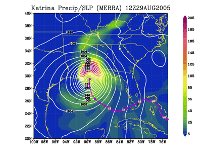
This visualization shows the development and landfall of Katrina as viewed from MERRA data. See the MERRA blog for a discussion and link to this animation and validating radar data.
» Read More at the MERRA Blog
» Read More at the MERRA Blog
2008
Presidents Day 1979 Snowstorm animation
[ CLICK IMAGE BELOW TO ANIMATE ] · [ VIEW LARGE ANIMATION ] · [ STOP ANIMATION ]
![[ VIEW LARGE ANIMATION ]](/reanalysis/MERRA/MERRA_cld_slp_anim.gif)
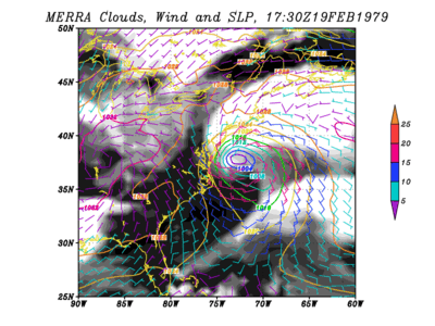
This visualization shows the development of the severe President's Day 1979 snow storm. The color contours are the sea level pressure (hPa), the color wind barbs are the surface layer winds (m/s values are colored according to the right side color bar), and total cloud fraction is shaded from black (no cloud) to white (complete cloud cover). This is generated from MERRA data currently available at the GES DISC.