

MERRA: MODERN ERA-RETROSPECTIVE ANALYSIS FOR RESEARCH AND APPLICATIONS
MERRA Basic Climate Analysis
The GEOS5-MERRA reanalysis products will be compared with other reanalysis products and tested against several verification data sets. At present we use the GEOS4-CERES experiment as a demonstration and placeholder. The GEOS4-CERES reprocessing was performed to support the CERES instrument team research efforts. It is not publicly available.
| NVAP | GPCP | GSSTF | Land Heat Fluxes |
| data product | latitude x longitude |
|---|---|
| GEOS4-CERES | 1.0 degree x 1.25 degree |
| ECMWF ERA40 | 2.5 degree x 2.5 degree |
| JRA-25 | 1.125 degree x 1.125 degree |
| NCEP R-2 | 1.875 degree x 2 degree |
| NVAP | 1.0 degree x 1.0 degree |
| GPCP | 2.5 degree x 2.5 degree |
| GSSTF | 1.0 degree x 1.0 degree |
NVAP Verification
In this section we intercompare total precipitable water (TPW) products against the NASA Water Vapor Project ( NVAP ). The four compared data sets are the GMAO assimilation experiment GEOS4-ceres, the ECMWF 40-year reanalysis ( ERA-40 ), the Japanese 25-year reanalysis ( JRA-25 ), and the NCEP reanalysis-2 ( NCEP R-2 ). These comparisons are straightforward plots of the various reanalyses against an appropriate verification baseline (e.g., similar to the publication Amenu, G.G. and Kumar, P. BAMS 2005; 86(2):245-256 titled "NVAP and Reanalysis-2 Global Precipitable Water Products").Click on any image to expand it in a separate window.
Figure 1.
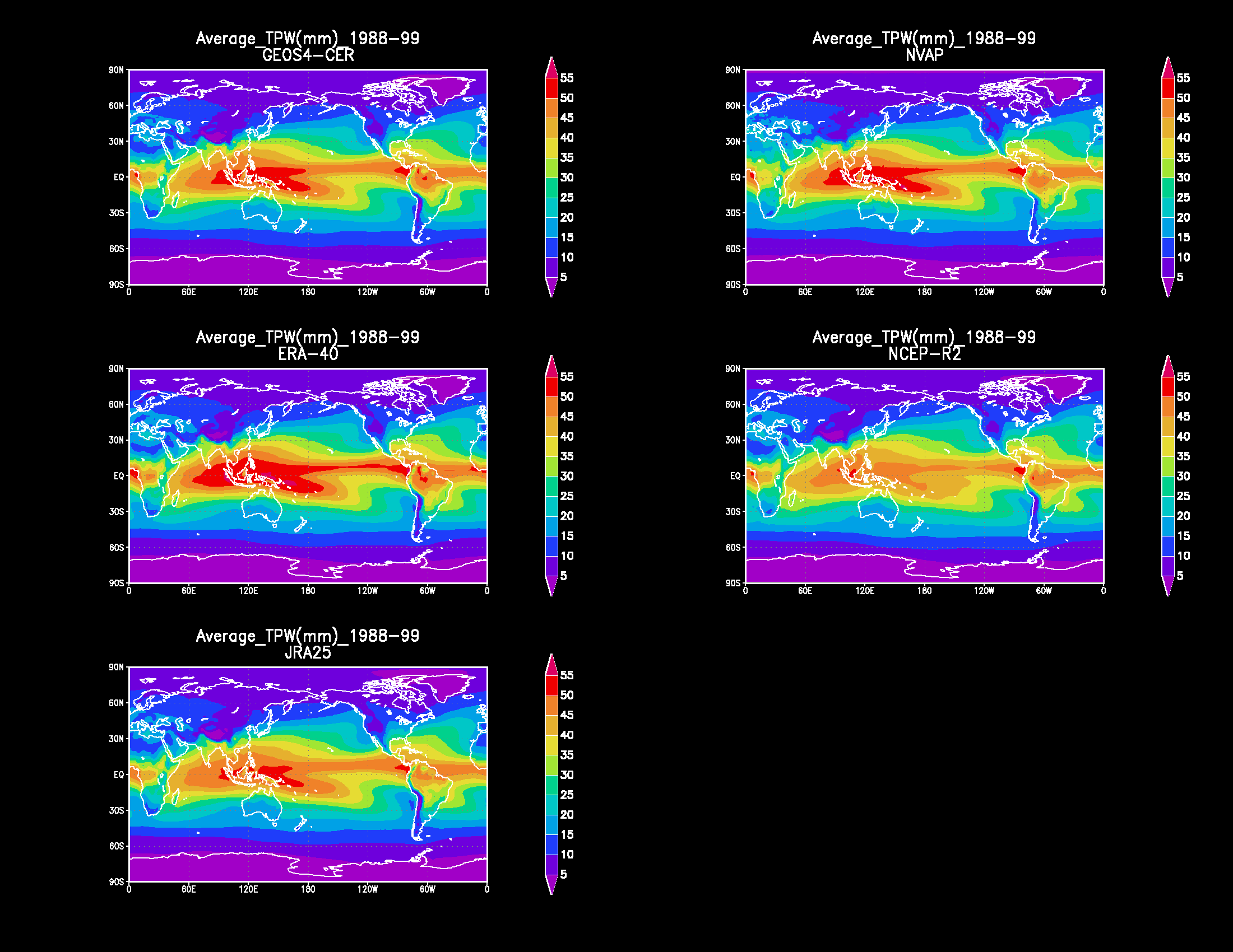
|
Total precipitable water (TPW) global
spatial distribution of 12-yr (1988-99) average for the five data sets
GEOS4-CERES (upper left), NVAP (upper right), ERA-40 (middle left), NCEP-R2 (middle right), and JRA-25 (lower left). |
Figure 2.
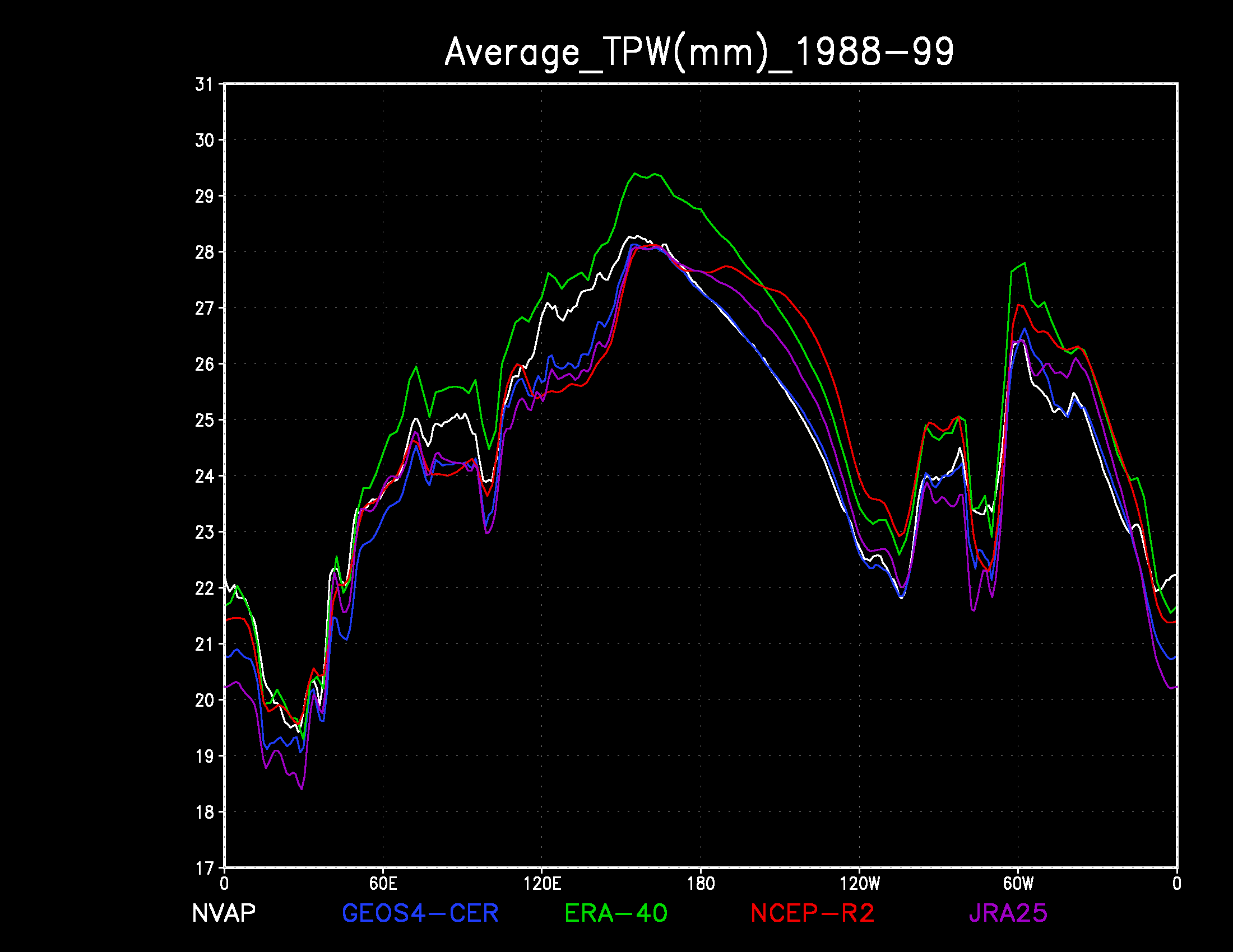
|
TPW zonal profile (TPW versus longitude) of the meridional mean
for 12-yr (1988-99) average for the five data sets
NVAP (white), GEOS4-CERES (blue), ERA-40 (green), NCEP-R2 (red), and JRA-25 (purple). |
Figure 3.
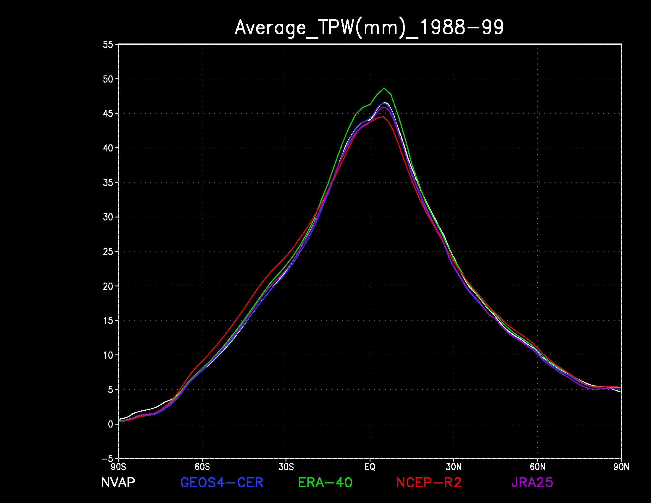
|
TPW meridional profile (TPW versus latitude) of the zonal mean
for 12-yr (1988-99) average for the five data sets
NVAP (white), GEOS4-CERES (blue), ERA-40 (green), NCEP-R2 (red), and JRA-25 (purple). |
Figure 4.
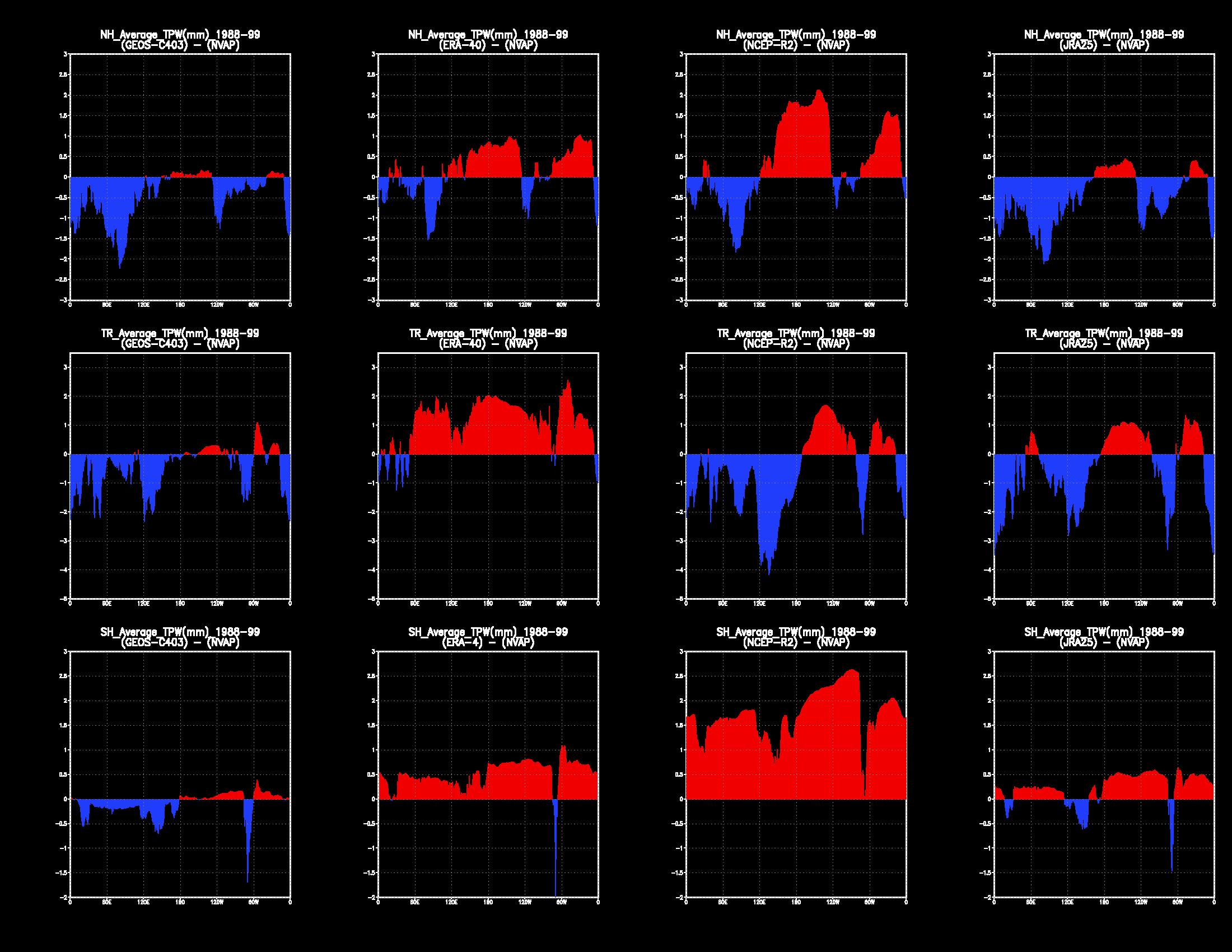
|
These twelve figures are each a zonal profile of the difference
in the TPW meridional means of two data sets:
Each plot portrays a data set minus NVAP, with positive differences
shown in red and negative differences shown in blue.
The four columns are, from left to right, GEOS-CERES minus NVAP, ERA-40 minus NVAP, NCEP R-2 minus NVAP, and JRA-25 minus NVAP. The three rows are, from top to bottom, Northern hemisphere differences (above latitude 30), Southern hemisphere differences (below latitude -30), and Tropical differences (latitudes -30 to 30). |
Figure 5.
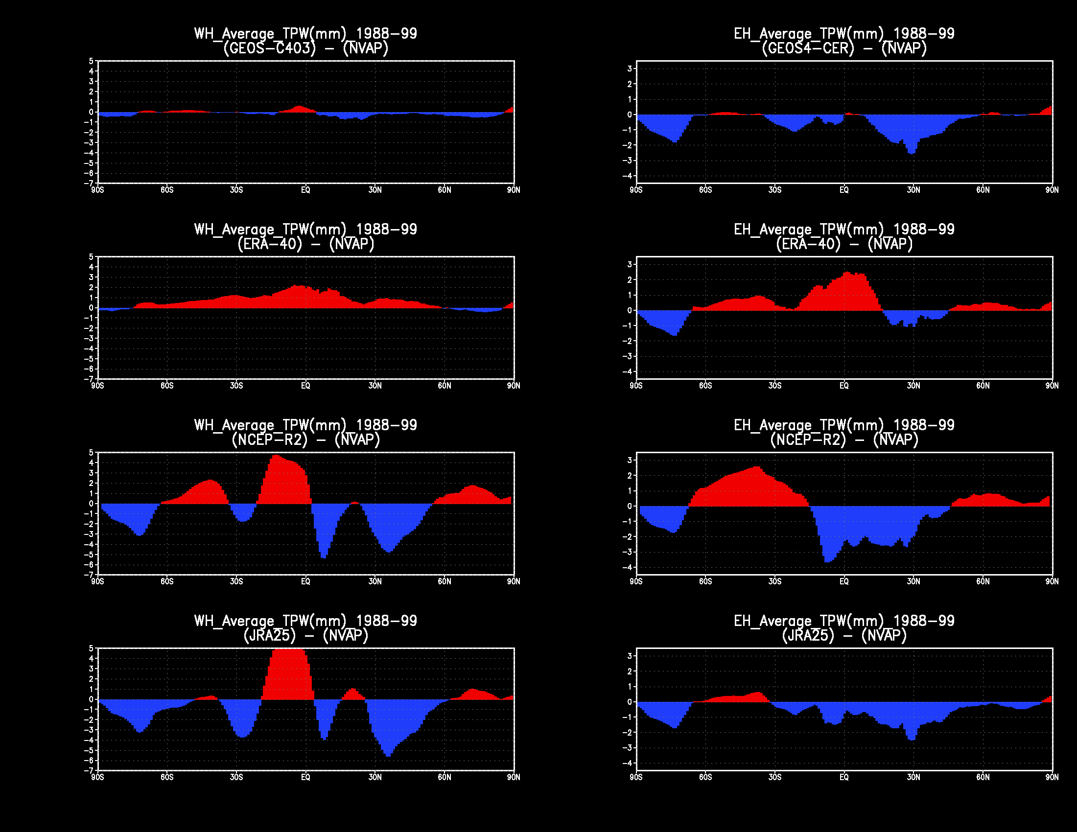
|
These eight figures are each a meridional profile of the difference
in the TPW zonal means of two data sets:
Each plot portrays a data set minus NVAP, with positive differences
shown in red and negative differences shown in blue.
The four rows are, from top to bottom, GEOS-CERES minus NVAP, ERA-40 minus NVAP, NCEP R-2 minus NVAP, and JRA-25 minus NVAP. The two columns are, from left to right, Western hemisphere differences, and Eastern hemisphere differences. |
Figure 6.
|
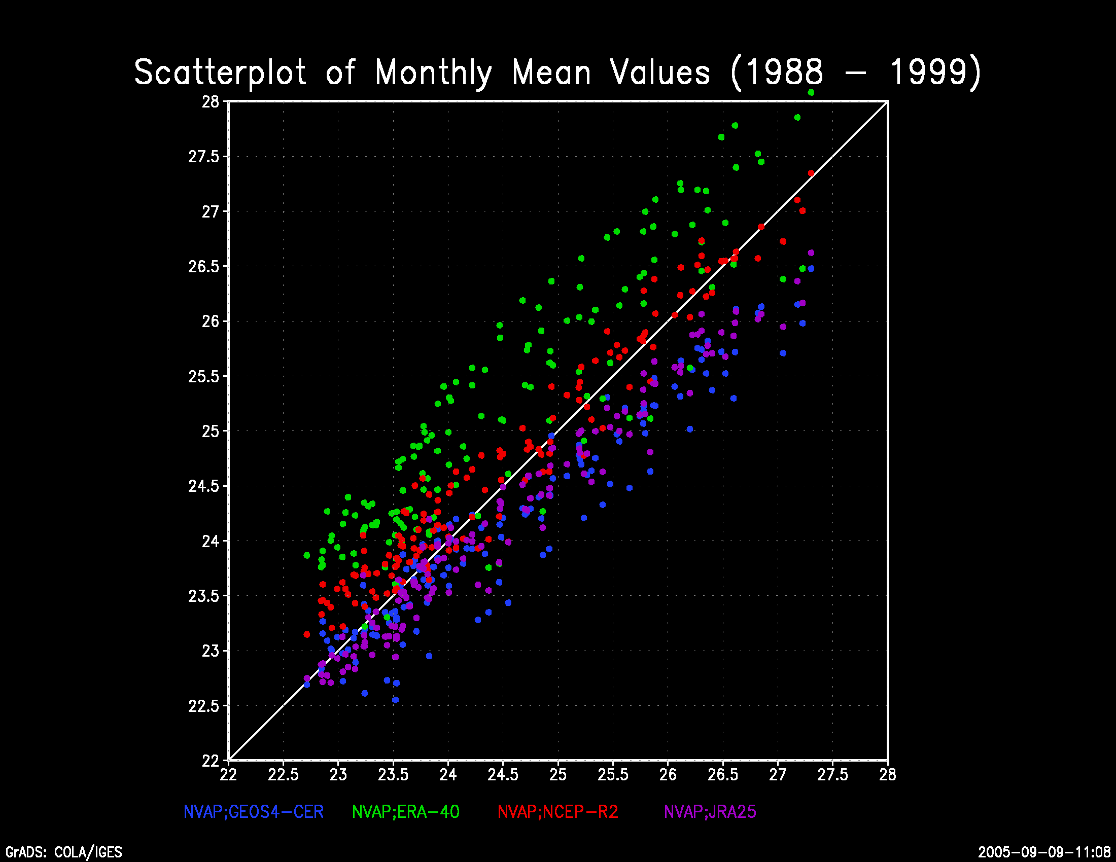
Scatterplots of monthly mean TPW values from 1988 to 1999.
The horizontal axis is always NVAP and the vertical axis plots
GEOS4-CERES (blue), ERA-40 (green), NCEP-R2 (red), and JRA-25 (purple). |
Figure 7.
|
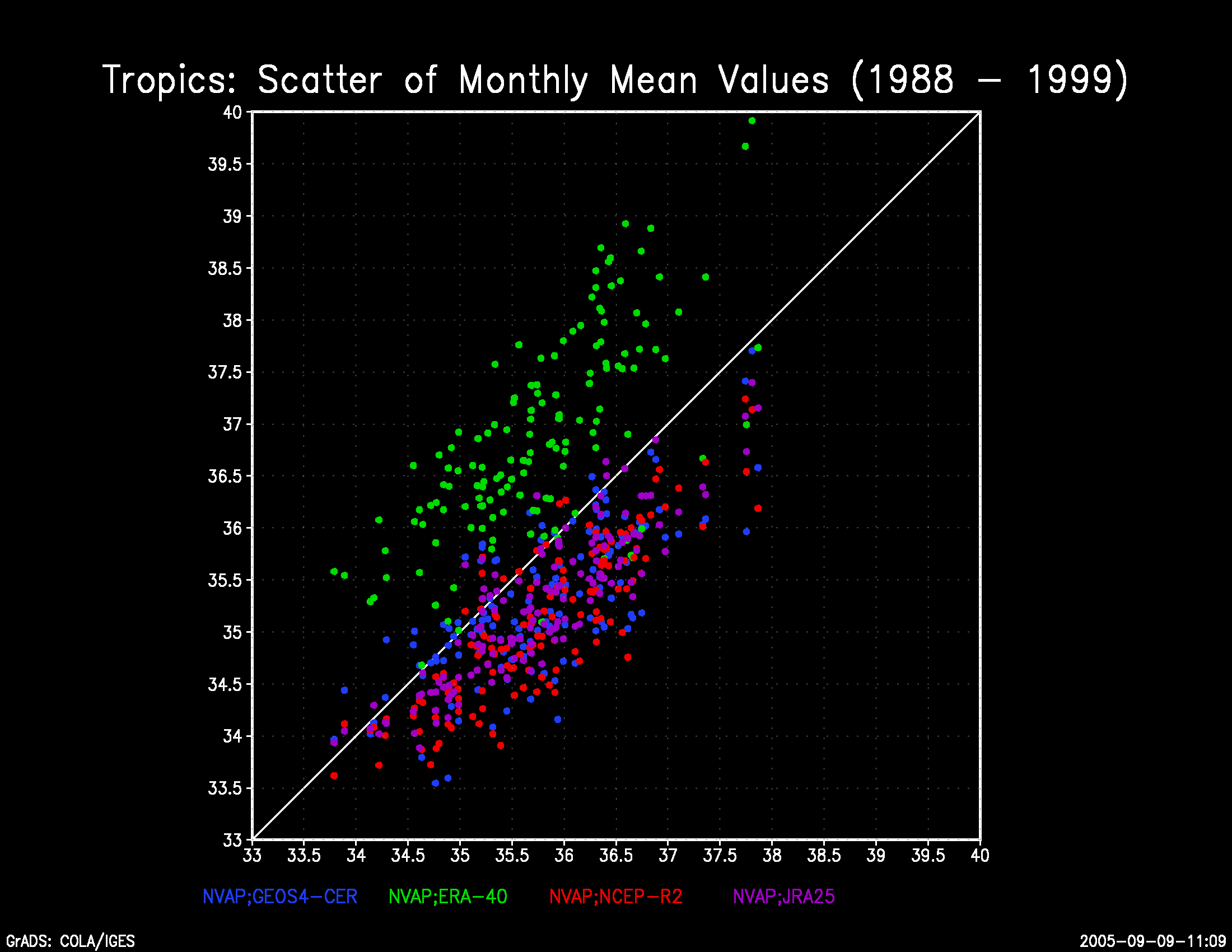
For the tropics only,
scatterplots of monthly mean TPW values from 1988 to 1999.
The horizontal axis is always NVAP and the vertical axis plots
GEOS4-CERES (blue), ERA-40 (green), NCEP-R2 (red), and JRA-25 (purple). |
Figure 8.
|
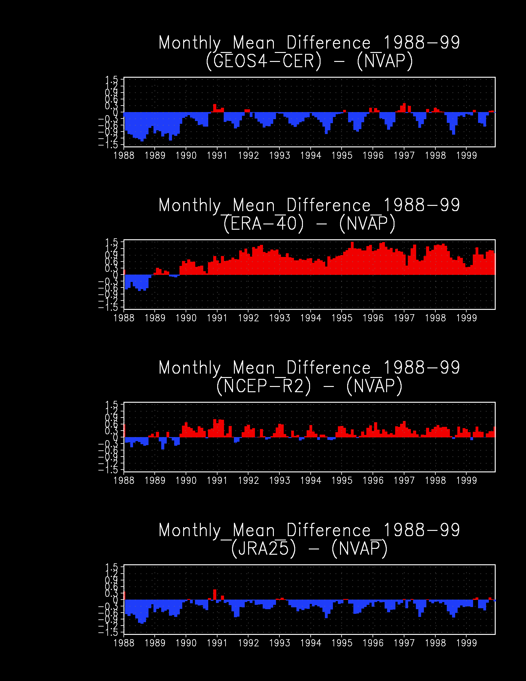
These four figures are each a plot over time of the difference
in the monthly mean TPW of two data sets.
Each plot portrays a data set minus NVAP, with positive differences
shown in red and negative differences shown in blue.
The three rows are, from top to bottom,
GEOS-CERES minus NVAP, ERA-40 minus NVAP, NCEP R-2 minus NVAP, and JRA-25 minus NVAP. |
Figure 9.
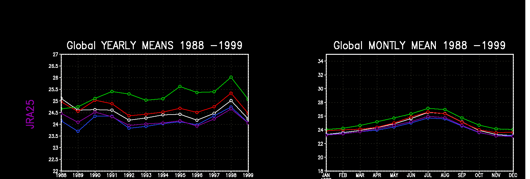
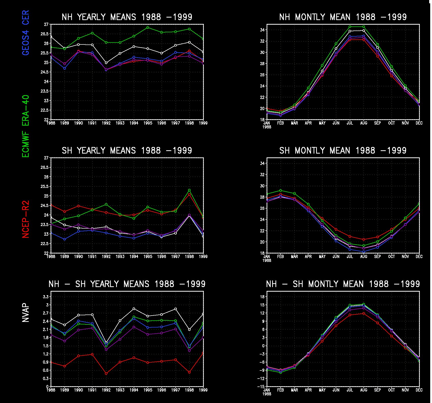
|
These eight figures are each a plot over time of mean TPW.
The column on the left is the annual average of TPW,
averaged over one year at a time,
for the 12 years 1988 to 1999.
The column on the right is the monthly average TPW,
averaged over the 12 years 1988 through 1999,
for the 12 months of a year.
The four rows are, from top to bottom,
global TPW, Northern Hemisphere, Southern Hemisphere,
and the difference of Northern minus Southern Hemisphere.
In each plot, the five data sets are
NVAP (white), GEOS4-CERES (blue), ERA-40 (green), NCEP-R2 (red), and JRA-25 (purple). |
GPCP Verification
In the images below, we intercompare precipitation rates (PRATE) against the Global Precipitation Climatology Project ( GPCP ). The four compared data sets are the GMAO assimilation experiment GEOS4-ceres, the ECMWF 40-year reanalysis ( ERA-40 ), the Japanese 25-year reanalysis ( JRA-25 ), and the NCEP reanalysis-2 ( NCEP R-2 ). These comparisons are straightforward plots of the various reanalyses against an appropriate verification baseline (e.g., similar to the publication Amenu, G.G. and Kumar, P. BAMS 2005; 86(2):245-256 titled "NVAP and Reanalysis-2 Global Precipitable Water Products").In addition, a separate web page is devoted to variations in precipitation over time, versus GPCP.
Click on any image to expand it in a separate window.
Figure 1.
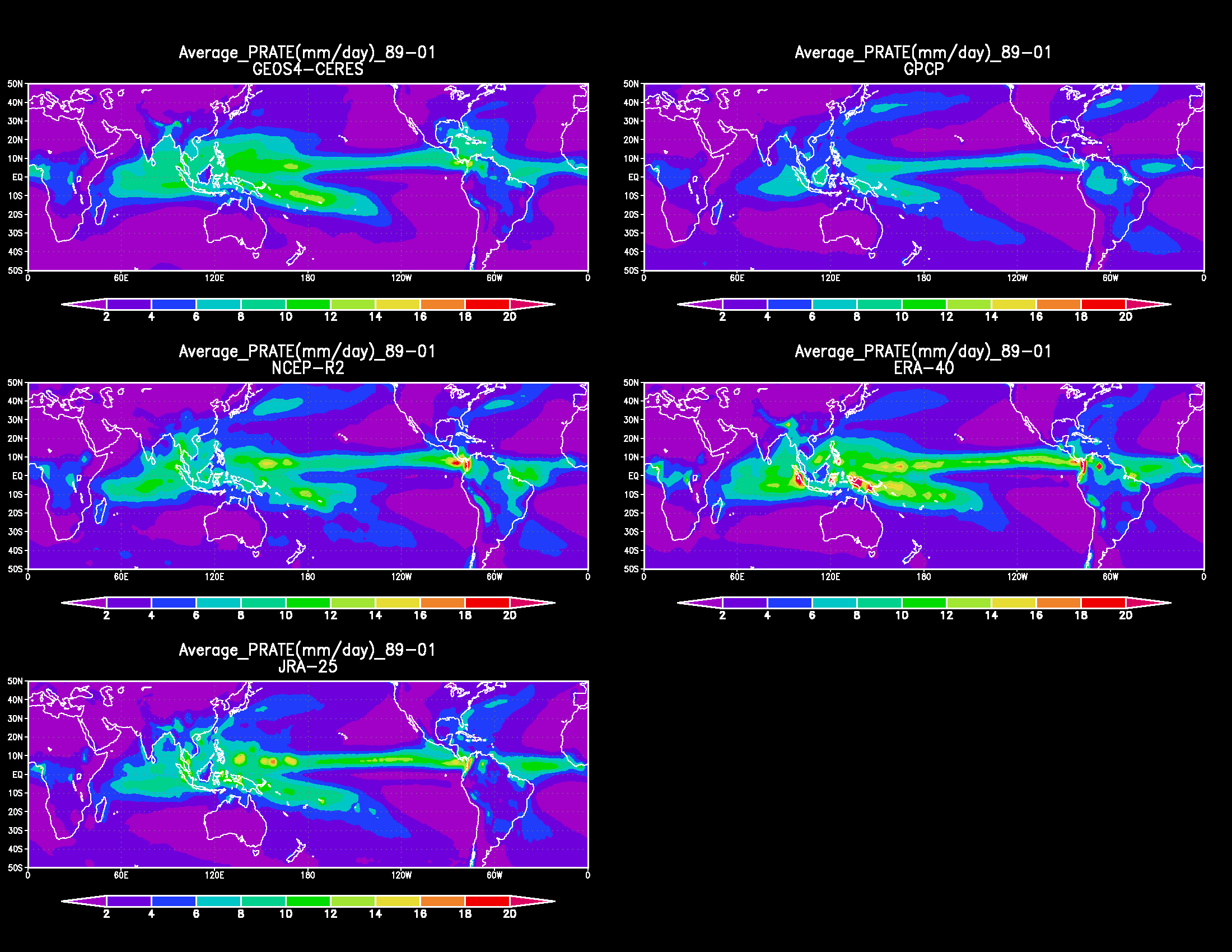
|
Precipitation rate (mm/day)
spatial distribution of 13-yr (1989-2001) average over the
longitude range from -50 to 50 degrees.
Plotted for the five data sets
GEOS4-CERES (upper left), NVAP (upper right), NCEP-R2 (middle left), ERA-40 (middle right), and JRA-25 (lower left). |
Figure 2.
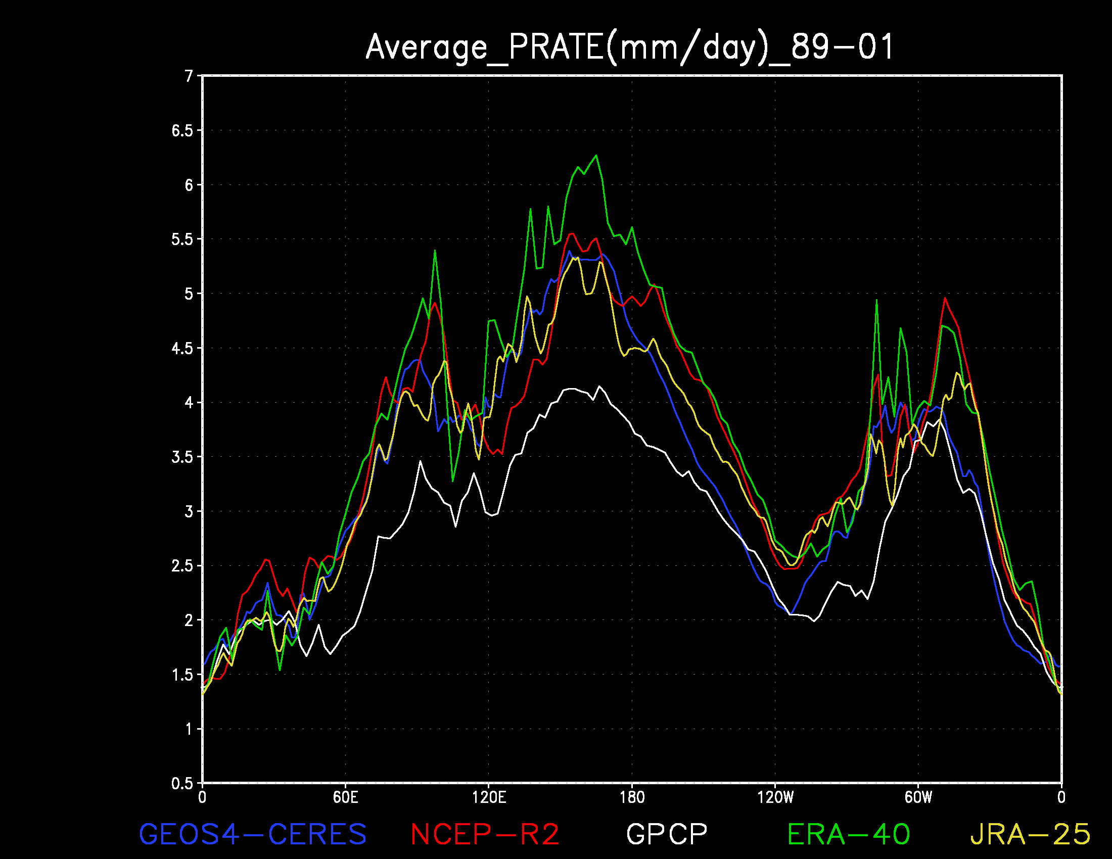
|
Precipitation rate (mm/day)
zonal profile (rate versus longitude) of the meridional mean
for 13-yr (1989-2001) average for the five data sets
GPCP (white), GEOS4-CERES (blue), NCEP-R2 (red), ERA-40 (green), and JRA-25 (yellow). |
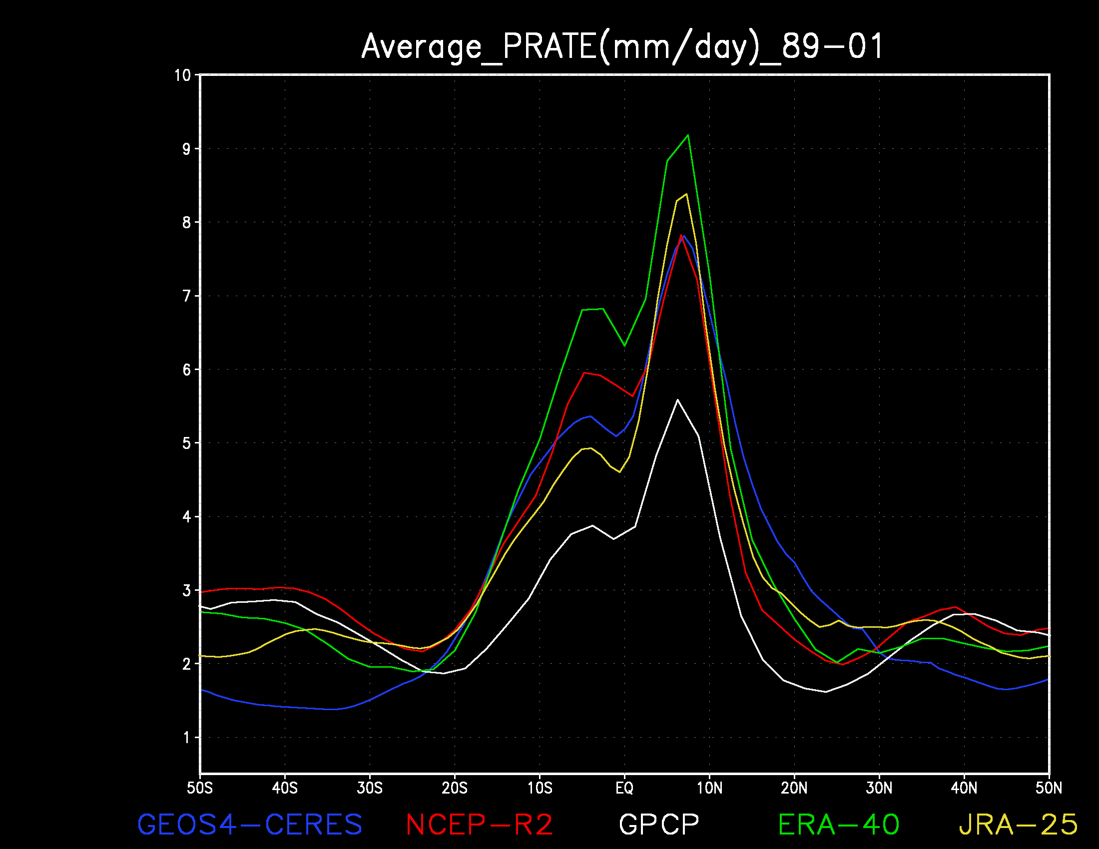
Figure 3.
|
Precipitation rate (mm/day)
meridional profile (rate versus latitude) of the zonal mean
for 13-yr (1989-2001) average for the five data sets
GPCP (white), GEOS4-CERES (blue), NCEP-R2 (red), ERA-40 (green), and JRA-25 (yellow). |
Figure 4.
|
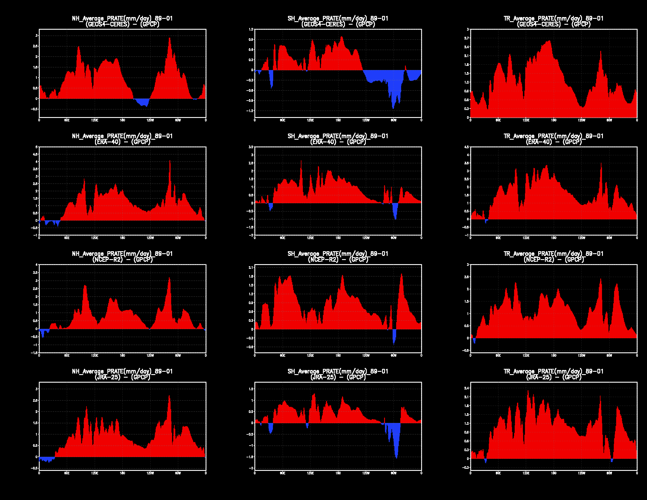
These twelve figures are each a zonal profile of the difference in
the precipitation rate (mm/day) meridional means of two data sets:
Each plot portrays a data set minus GPCP,
with positive differences shown in red and negative differences shown in blue.
The three columns are, from left to right, Northern hemisphere differences, Southern hemisphere differences, and Tropical differences. The four rows are, from top to bottom, GEOS4-CERES minus GPCP, ERA-40 minus GPCP, NCEP R-2 minus GPCP, and JRA-25 minus GPCP. |
Figure 5.
|
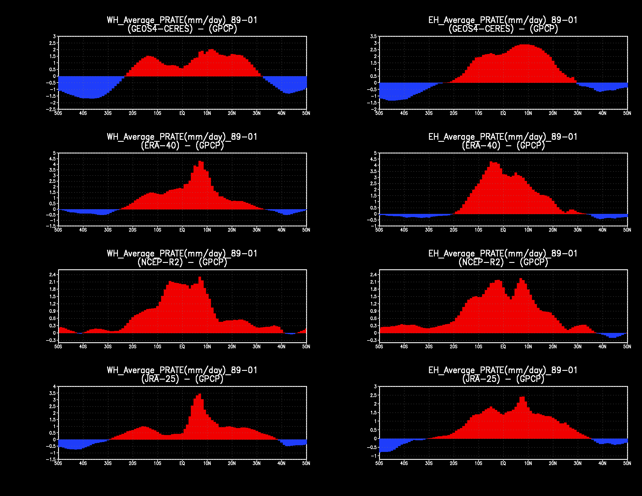
These eight figures are each a meridional profile of the difference in the
precipitation rate (mm/day) zonal means of two data sets:
Each plot portrays a data set minus GPCP, with
positive differences shown in red and negative differences shown in blue.
The four rows are, from top to bottom, GEOS4-CERES minus GPCP, ERA-40 minus GPCP, NCEP R-2 minus GPCP, and JRA-25 minus GPCP. The two columns are, from left to right, Western hemisphere differences and Eastern hemisphere differences. |
GSSTF Verification
In this section we intercompare evaporation rate (EVAP) against the Goddard Satellite-based Surface Turbulent Fluxes data ( GSSTF ). The three compared data sets are the GMAO assimilation experiment GEOS4-ceres, the ECMWF reanalysis ( ERA-40 ), and the NCEP reanalysis-2 ( NCEP R-2 ). These comparisons are straightforward plots of the various reanalyses against an appropriate verification baseline (e.g., similar to the publication Amenu, G.G. and Kumar, P. BAMS 2005; 86(2):245-256 titled "NVAP and Reanalysis-2 Global Precipitable Water Products").Click on any image to expand it in a separate window.
Figure 1.
|
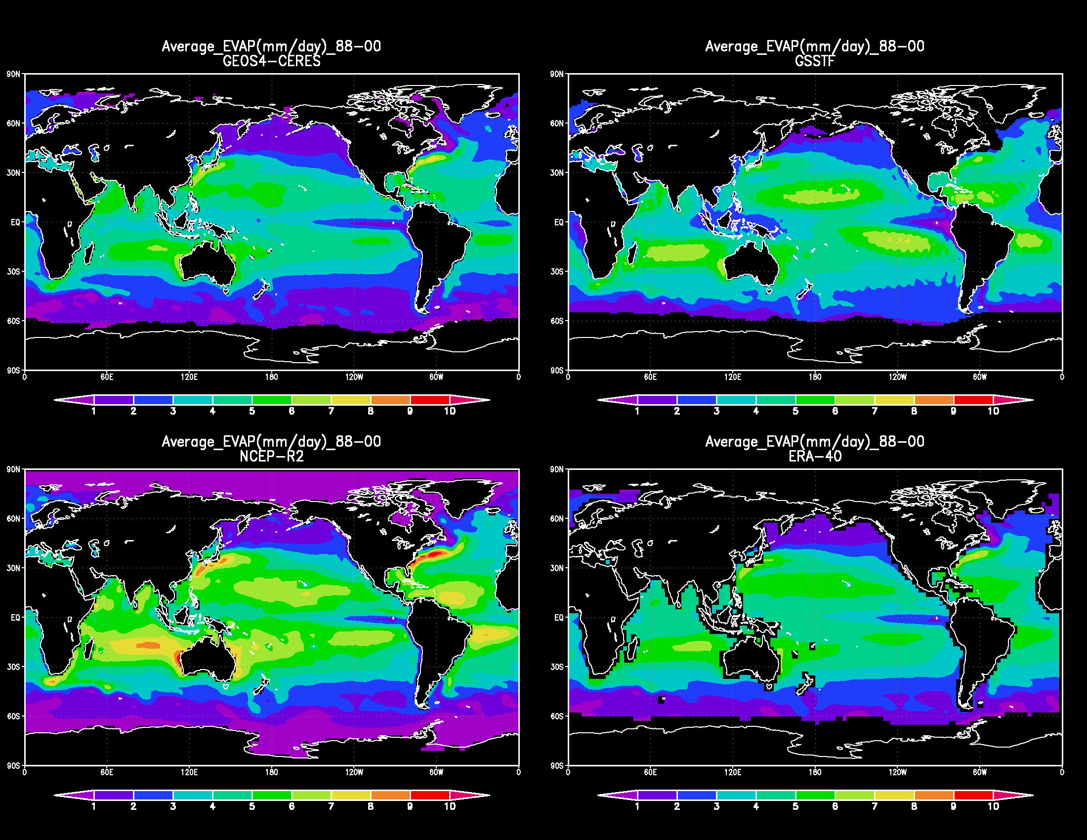
Evaporation rate (mm/day) spatial distribution of 13-yr (1988-2000)
global average for the four data sets
GEOS4-CERES (upper left), GSSTF (upper right), NCEP-R2 (lower left), and ERA-40 (lower right). |
Figure 2.
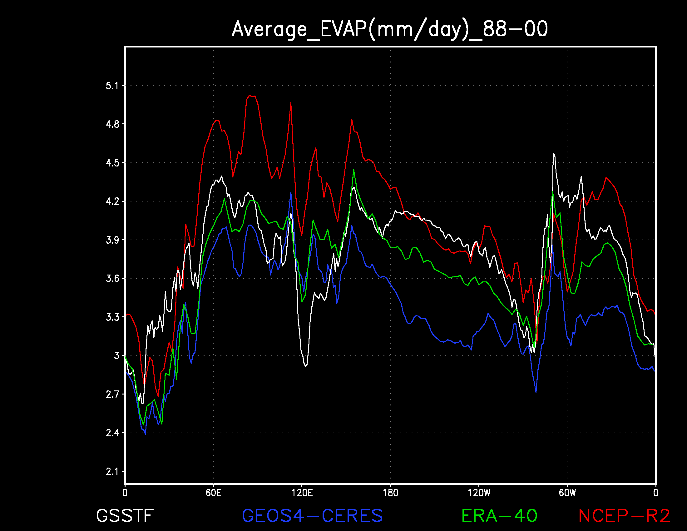
|
Evaporation rate (mm/day)
zonal profile (rate versus longitude) of the meridional mean
for 13-yr (1988-2000) average for the four data sets
GSSTF (white), GEOS4-CERES (blue), ERA-40 (green), and NCEP-R2 (red). |
Figure 3.
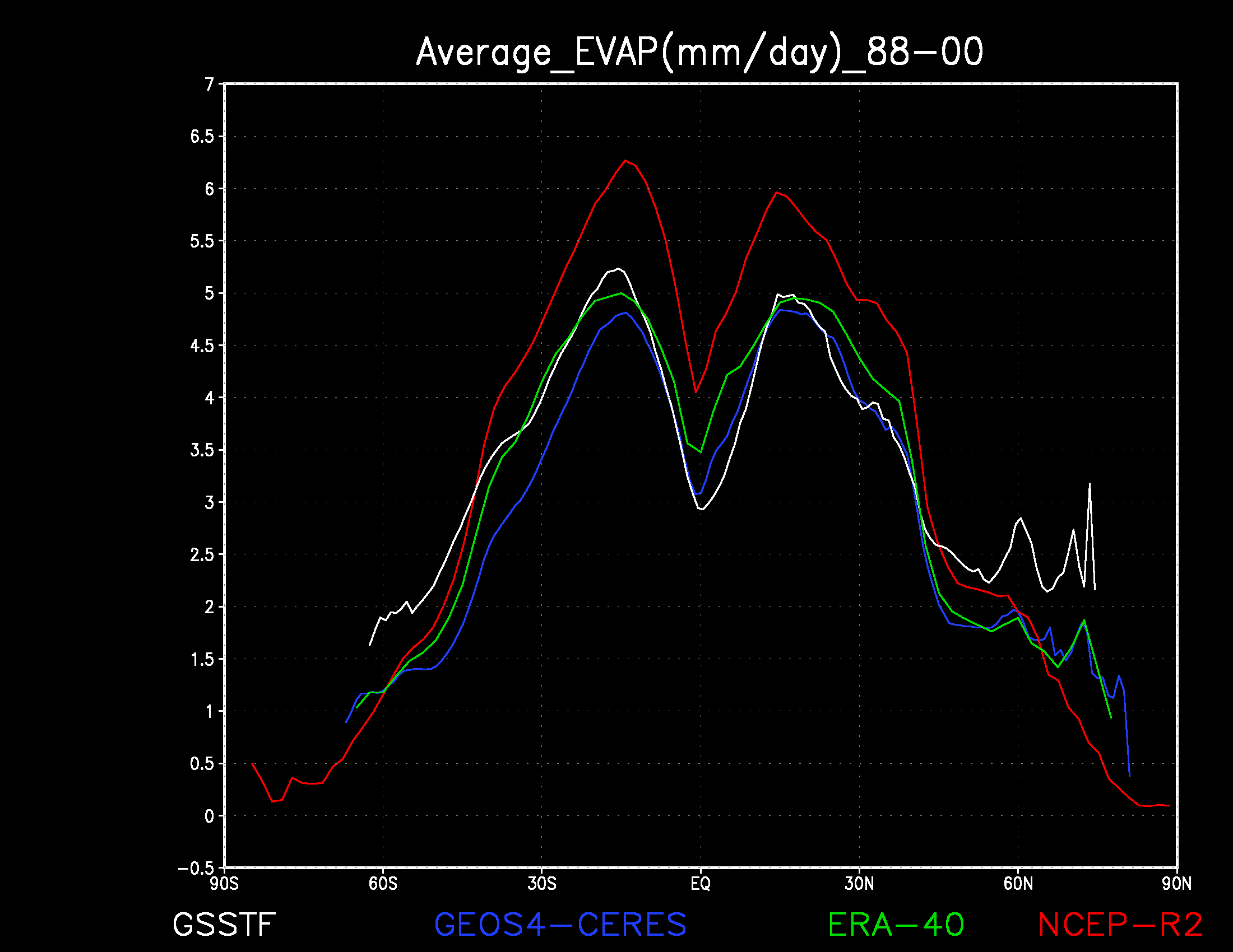
|
Evaporation rate (mm/day)
meridional profile (rate versus latitude) of the zonal mean
for 13-yr (1988-2000) average for the four data sets
GSSTF (white), GEOS4-CERES (blue), ERA-40 (green), and NCEP-R2 (red). |
Figure 4.
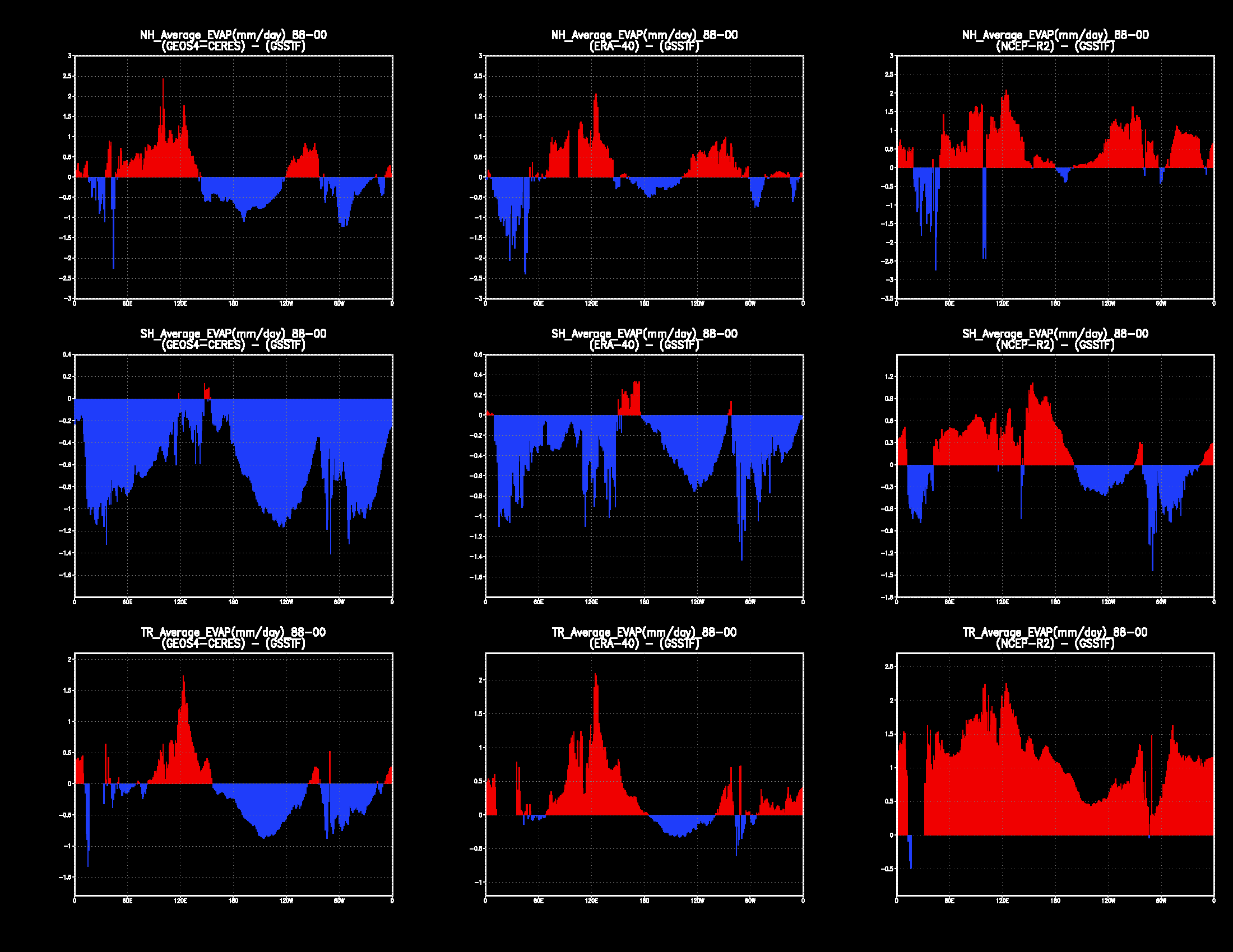
| These nine figures are each a zonal profile of the difference in the evaporation rate (mm/day) meridional means of two data sets: Each plot portrays a data set minus GSSTF, with positive differences shown in red and negative differences shown in blue. The three columns are, from left to right, GEOS4-CERES minus GSSTF, ERA-40 minus GSSTF, and NCEP R-2 minus GSSTF. The three rows are, from top to bottom, Northern hemisphere differences, Southern hemisphere differences, and Tropical differences. |
Figure 5.
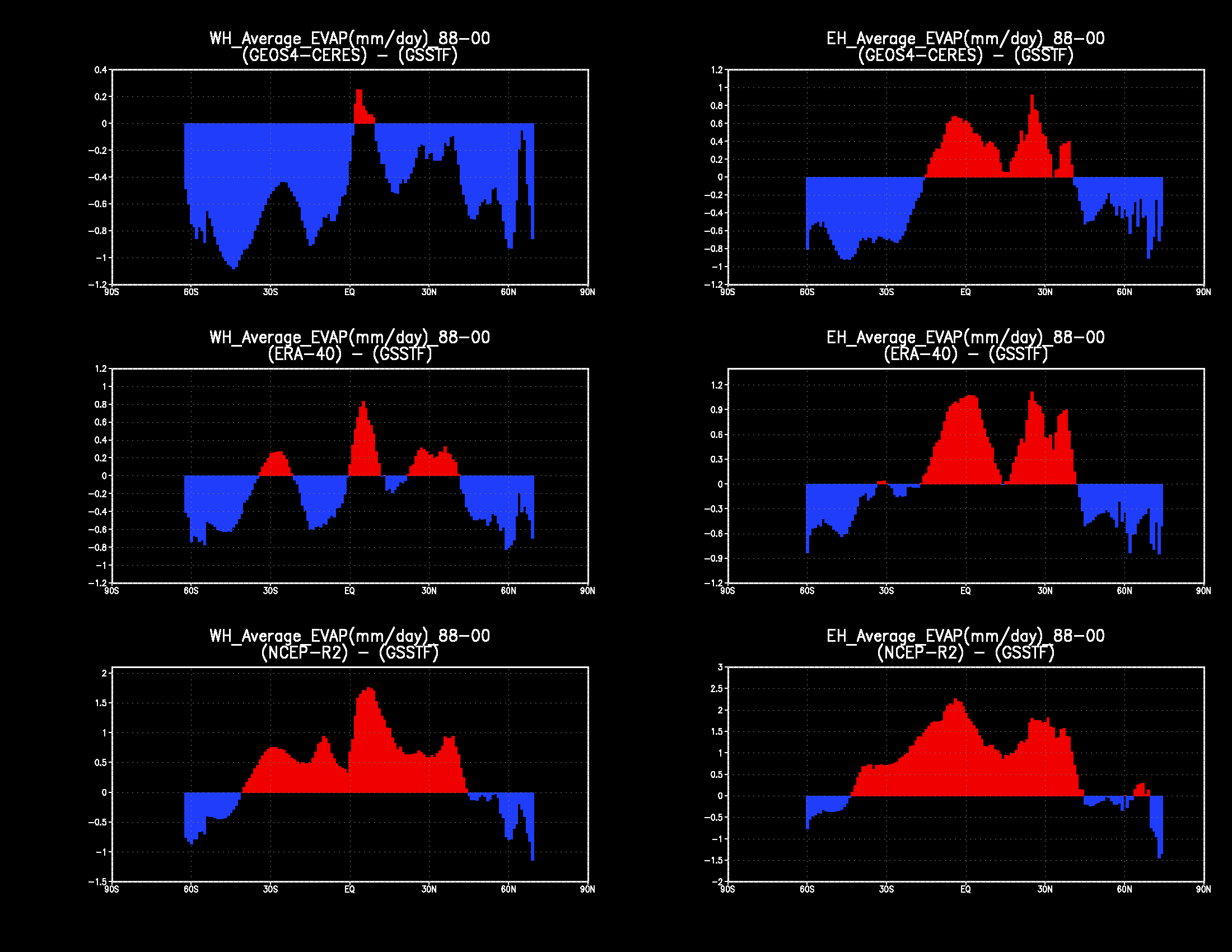
| These six figures are each a meridional profile of the difference in the evaporation rate (mm/day) zonal means of two data sets: Each plot portrays a data set minus GSSTF, with positive differences shown in red and negative differences shown in blue. The three rows are, from top to bottom, GEOS4-CERES minus GSSTF, ERA-40 minus GSSTF, and NCEP R-2 minus GSSTF. The two columns are, from left to right, Western hemisphere differences and Eastern hemisphere differences. |
Verification against Land Heat Fluxes
In this section we intercompare the energy fluxes of several different data sets against the GEWEX verification data from the Global Soil Wetness Project ( GSWP2 ). Four of the compared data sets are reanalyses of atmospheric assimilation systems: the GMAO GEOS4-CERES, the NCEP reanalysis-2 ( NCEP R-2 ), the ECMWF 40-year reanalysis ( ERA-40 ), and the Japanese 25-year reanalysis ( JRA-25 ). Another two comparisons come from the LDAS project, in which different Land Data Assimilation Systems are forced by observations. We compare energy fluxes from the NCAR Community Land Model ( CLM2 ), and the GMAO MOSAIC land model ( MOSAIC ).
Click on any image to expand it in a separate window.
| data product | latitude x longitude |
|---|---|
| GEOS4-CERES | 1.0 degree x 1.25 degree |
| NCEP R-2 | 1.875 degree x 2 degree |
| ECMWF ERA40 | 2.5 degree x 2.5 degree |
| JRA-25 | 1.125 degree x 1.125 degree |
| GSWP2 | 1.0 degree x 1.0 degree |
| CLM2 | 1.0 degree x 1.0 degree |
| MOSAIC | 1.0 degree x 1.0 degree |
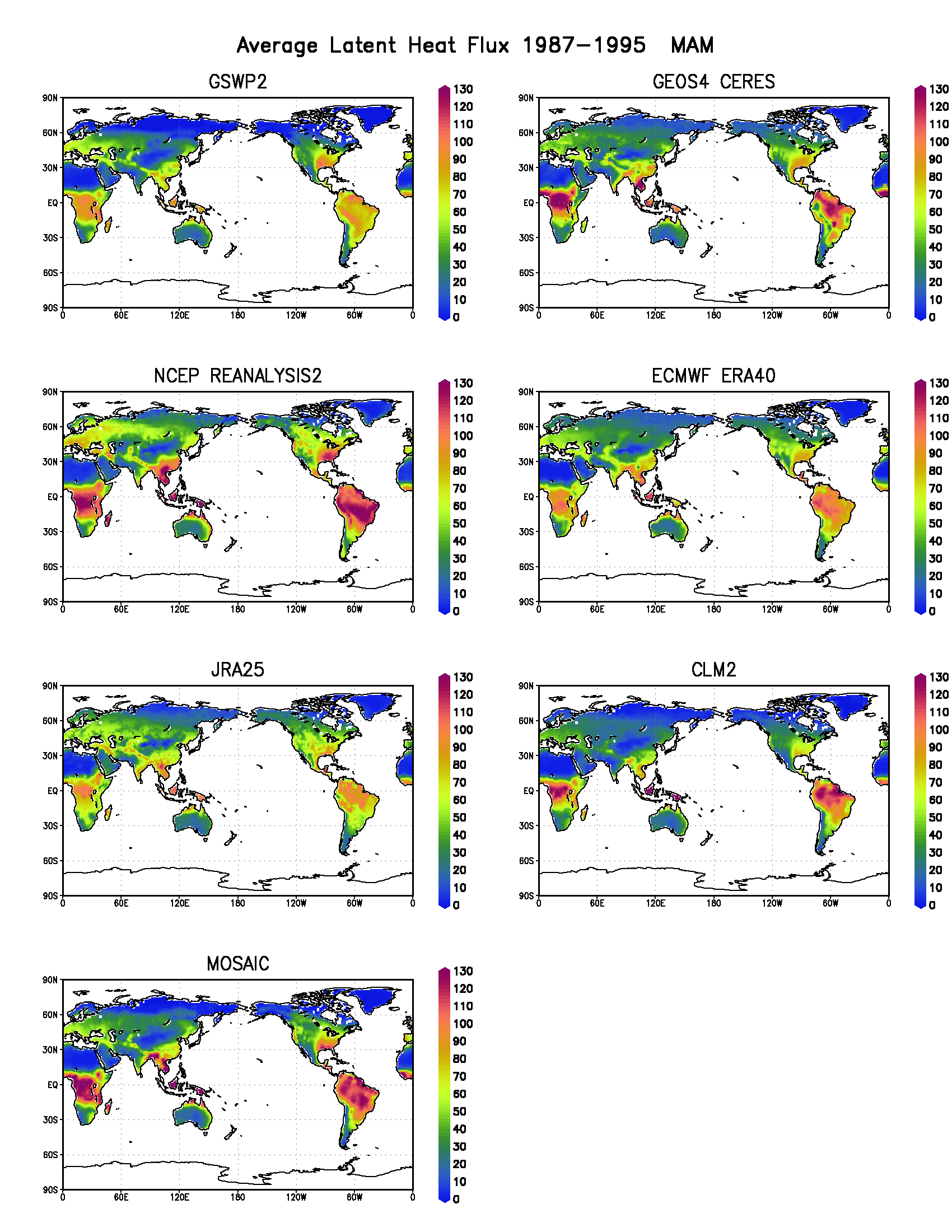
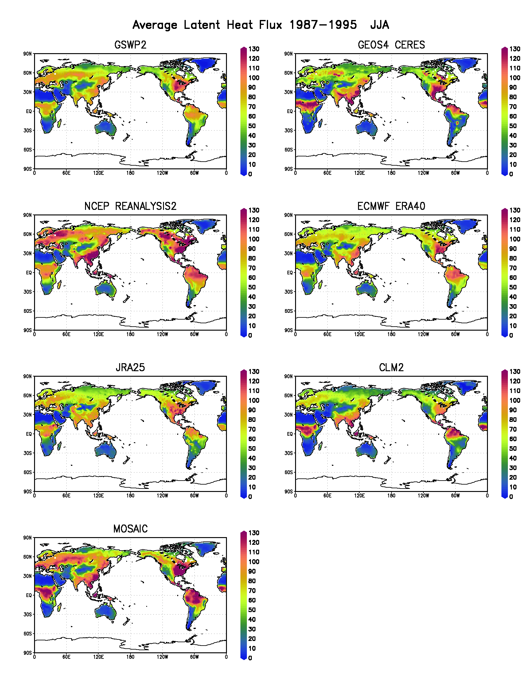
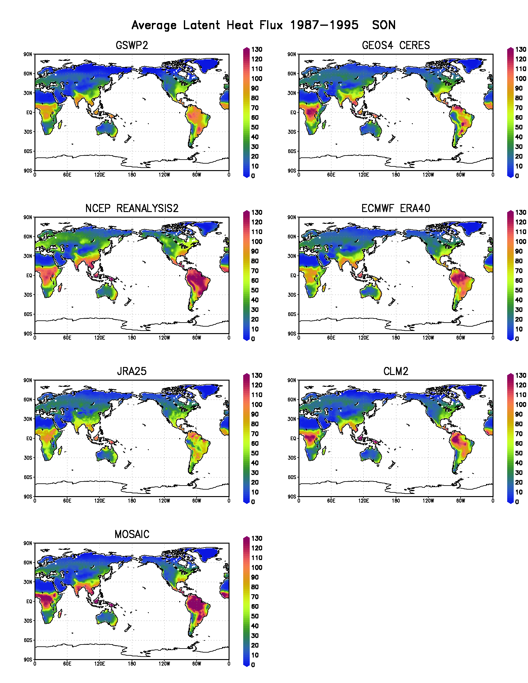
Figure 1.
Average Latent Heat Flux global spatial distribution
over the period 1987-1995 for the four seasons.
In each plot, the seven maps are:
GSWP (top row left), GEOS4-CERES (top row right),
NCEP-R2 (second row left), ERA-40 (second row right),
JRA-25 (third row left), CLM2 (third row right), and
MOSAIC (bottom left).
The plotted seasons are:
Winter months DJF (upper left), Spring months MAM (upper right),
Summer months JJA (lower left), Spring months SON (lower right).

|
|
|
|
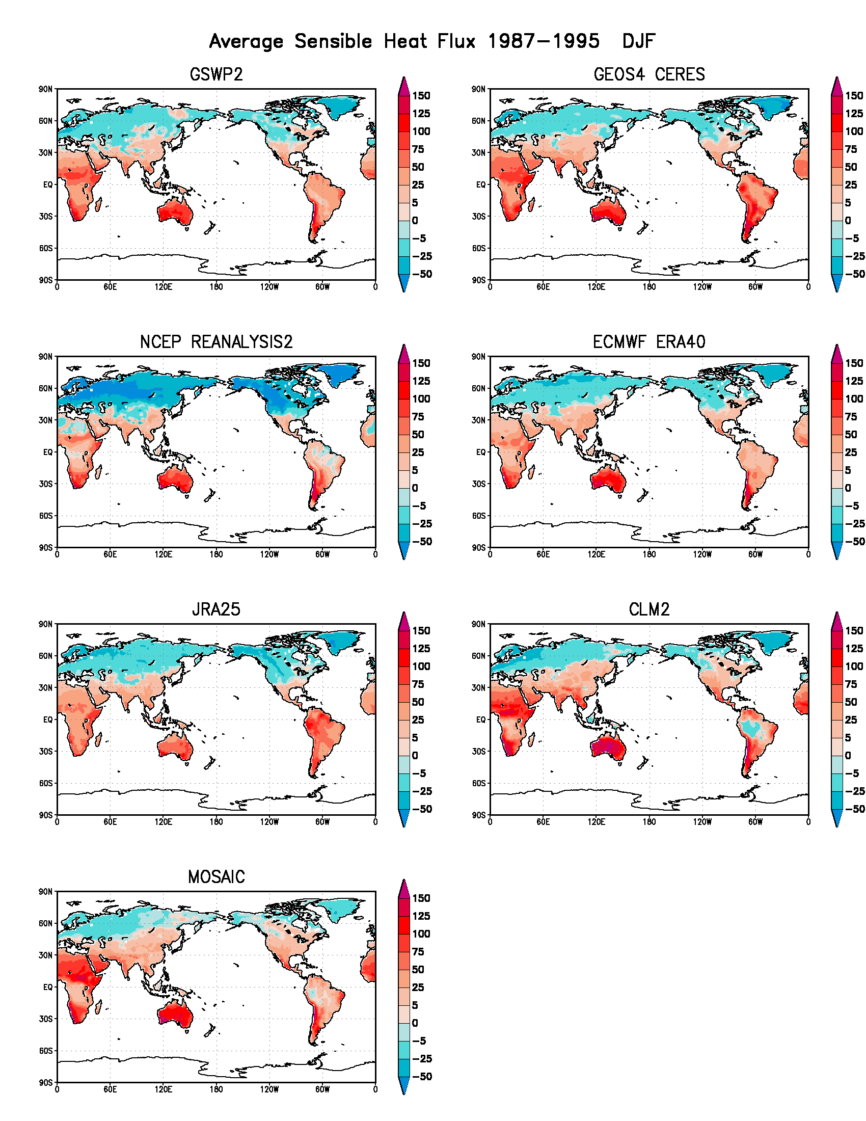
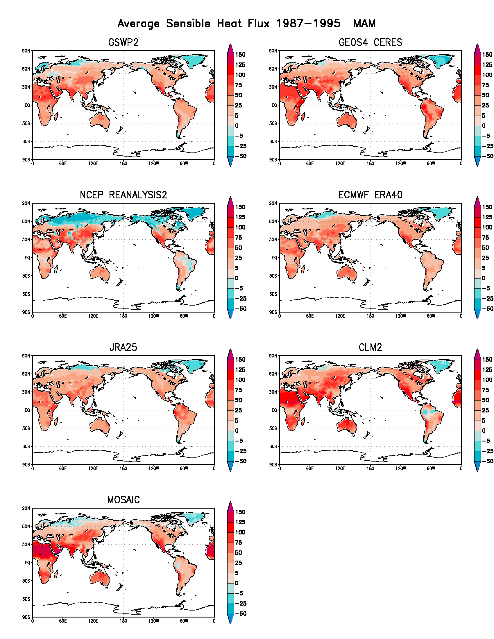
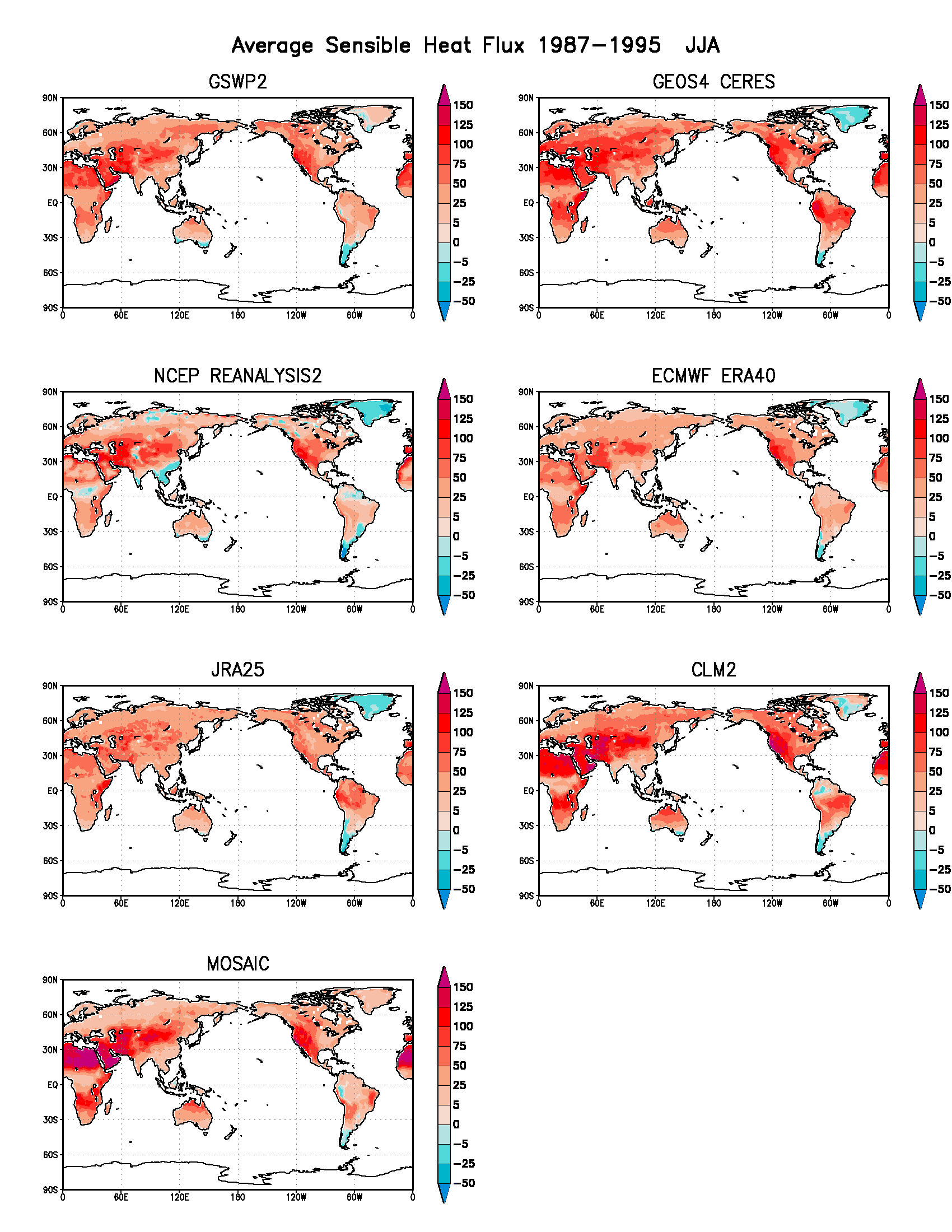
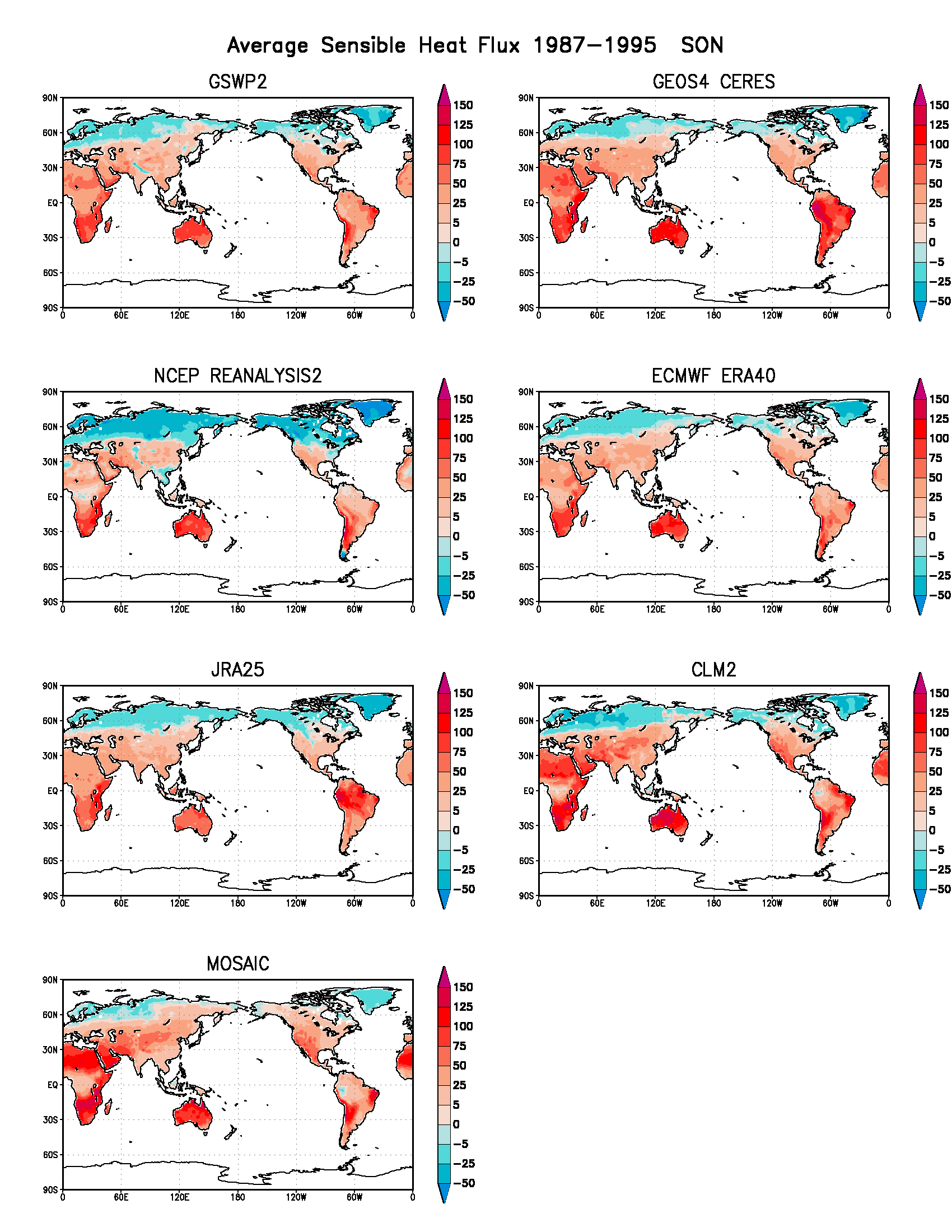
Figure 2.
Average Sensible Heat Flux global spatial distribution
over the period 1987-1995 for the four seasons.
In each plot, the seven maps are:
GSWP (upper left), GEOS4-CERES (upper right),
NCEP-R2 (middle left), ERA-40 (middle right), and
JRA-25 (lower left).
The plotted seasons are:
Winter months DJF (upper left), Spring months MAM (upper right),
Summer months JJA (lower left), Spring months SON (lower right).
|
|
|
|
Acknowledgements:
ECMWF ERA-40 data used here is the Basic 2.5 Degree Atmospheric data set in the ECMWF Level III-B archive obtained from their data server at data.ecmwf.int/products/data/archive/
NCEP Reanalysis 2 data provided by the NOAA-CIRES Climate Diagnostics Center, Boulder, Colorado, USA, from their web site at www.cdc.noaa.gov
NVAP data are available from NASA's Langley Distributed Active Archive Canter (DAAC) server at eosweb.larc.nasa.gov
GPCP merged analysis of pentad precipitation is created at the Climate Prediction Center (CPC). It is posted by NOAA at www1.ncdc.noaa.gov and by NASA at precip.gsfc.nasa.gov
GSSTF validation was performed with the monthly-mean version 2 product which is produced by the NASA GSFC research group (code 912) led by Dr. Shu-Hsien Chou. It is available through the NASA Goddard DAAC at disc.gsfc.nasa.gov/precipitation/
GSWP