Modern-Era Retrospective analysis for Research and Applications (MERRA)
Land Fractions
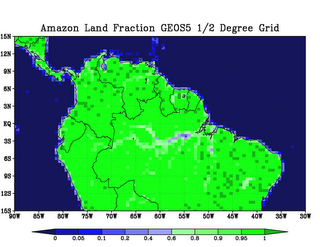
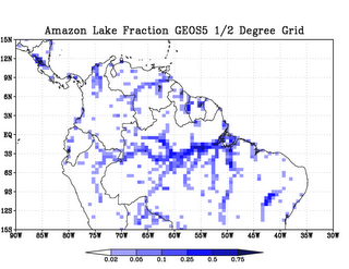
One feature in the GEOS5 GCM that is different previous reanalyses is fractional surface tiles, as opposed to a land/sea mask. Each grid box contains a fraction of land, water, lake or land ice. The fractions are based on the 1km Global Land Cover Characteristics (GLCC) database. Along coast lines, the land processes are blended with sea surface processes. Inland, lakes and rivers are also included. This will require some attention of users calculating precise budgets. For example, the grid box average evaporation that would be appropriate for an atmospheric budget, may not be appropriate for in-situ data comparisons and land surface budget studies, if the lake fraction is substantial. Figures showing some examples of land and lake fractions are shown below.
To support the analysis of land water and energy budgets, a land only output data collection will be produced (tavg1_2d_lnd_Nx in the MERRA File Specification Document). These grids would be for the land only fraction of the surface. Users will be able to differentiate land evaporation from total evaporation in grid boxes near the coast and near inland water bodies. Soil water (GWET variables) will show up in grid boxes that appear to be oceanic. The model does provide an integer land/ocean mask (variable name LWI). However, this is simply a 50% cutoff between land/land ice and ocean fractions. For some specific purposes, this may not be appropriate, and users should use the land fraction to develop their own mask.
Additionally, the land fraction is subset into tiles based on the Catchment hydrology. The land collection includes data from the catchments. For more information, the interested reader should review Koster et al. (2001, J. Geophys. Res. Vol. 105 , No. D20 , p. 24,809, 2000JD900327).
M. Bosilovich


