MERRA-Land
MERRA-Land is a land-only ("off-line") replay of the MERRA land model component with two key changes from MERRA:
- MERRA-Land precipitation forcing is based on merging a gauge-based data product from the NOAA Climate Prediction Center with MERRA precipitation.
- The Catchment land surface model used in MERRA-Land was updated from the "MERRA" version (used in GEOS-5.2.0) to the "Fortuna-2.5" version (used operationally in GEOS-5.7.2 since Aug 2011).
These two changes lead to various science improvements that are documented, for a preliminary version of the MERRA-Land data product, in Reichle et al. (2011) and, for the official MERRA-Land data product, in the MERRA-Land documentation.
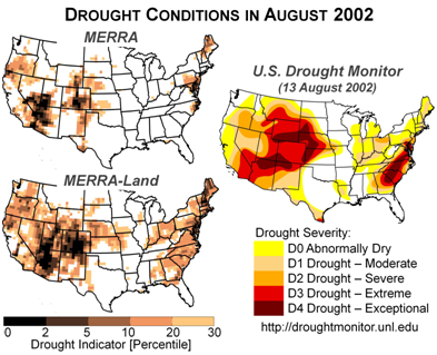
With a few exceptions, the MERRA-Land data appear more accurate than the original MERRA estimates and are thus recommended for those interested in using MERRA output for land surface hydrological studies. As an example, Figure 1 examines the drought conditions experienced across the western United States and along the East Coast during August 2002. The figure clearly demonstrates that MERRA-Land data are more consistent with the Drought Monitor than MERRA data.

See MERRA-Land Data Access for information on requesting the data.
See also MERRA-Land References.


