
Forecasting in the Southern Beaufort Sea for ARISE
Forecasting for the ARISE study in the southern Beaufort Sea on 16-September was particularly challenging due to rapidly evolving conditions. High pressure over the Beaufort Sea that had been present over the previous several days began to fragment and weaken. A low pressure center that had been parked over the southern Bering sea began to fill and move to the northeast. In between these two systems, a cloudy warm front was draped just offshore of the northern Alaskan coast. As the front began to occlude, the GEOS-5 model forecast a new low pressure centered near Prudhoe Bay. This new low would produce cyclonic motion in the lower atmosphere and disturb the cloud pattern along the coast.
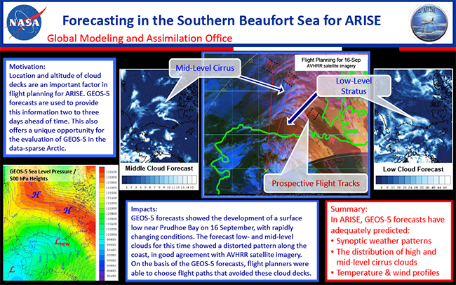
This forecast produced on 15-September agreed well with the following day’s AVHRR satellite imagery as shown on the NASA Mission Tools Suite display. Shown are forecast cloud optical thicknesses for middle and low clouds. The forecast of cloud type and location is important to ARISE mission planning. On this particular flight, the presence of cirrus clouds could pose a risk of confusing the retrieval of low cloud properties that were of interest. The mission planners were able to use the model forecast to plan alternative flight plans for the day’s conditions.