

Modern-Era Retrospective analysis for Research and Applications (MERRA)
Frequently Asked Questions (FAQ)
Note: If you can't find the answer you are looking for here, you may send your question to: merra-questions @lists.nasa.gov
MERRA began production in March 2008. After data is produced, the GMAO examines the data files in several ways to test the quality of the data. When we are confident that the data files are within the tolerance of the uncertainty we have seen in our validation experiments, we release it to the MDISC. At that point, they provisionally release it for download. We are not holding the data for any substantial length of time, before it can be accessed by the community.
When will my case study be produced and available? Or, when will X number of continuous years be available? Each stream is moving forward at ~10 days/real day, slightly faster for the early period as there are less observations to deal with. So, let's say ~2 months each week, so maybe in 7 months we can have 5 years.
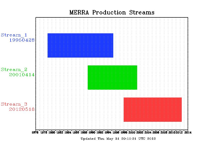
These are best case conditions that will not happen over long periods. The computers go down from time to time, scheduled and unscheduled. We estimate more than a year to finish any one stream, and likely 18 months to finish it all. Also, there is a chance that a severe bug may occur that affects the scientific integrity of the data. In this case, any time period may need to reprocessed delaying overall production. Check: http://gmao.gsfc.nasa.gov/operations/merra_status_production.gif for the current progress of the data streams. This provides the current date of each stream. Use 10 days per day, and add 25-50% slack to estimate when the date you are interested in will be produced.
The MERRA File Specification Document provides extensive information on the collections of variables, units and data files.
MERRA production will continue into the future, and does not have a set stopping time. However,version of the GSI analysis used by MERRA is not the latest,not be capable of ingesting new instrument data. This will become a serious issue if the new instrument is a replacement for an important older insturment that has failed or gone offline. So,feasible to do so.
The plan is to catch the first and second streams up to the beginning of the subsequent streams. The initial release of MERRA data will simply transition there. However, we plan to continue the first and second streams for two years,and variance between the two. Significant differences are not expected in most meteorological fields and diagnostics. Should any differences arise, we will revise the plan for the transition of streams.
MERRA's land parameterization is Randy Koster's Catchment model, but other surfaces, such as inland water, ocean surface and glaciers are also accounted for as sub-grid tiles. In the LND collection of variables, all the data are derived from the land model, and are not weighted according to the land fraction at that grid point. This data is provided to better compute land budgets for soil water and land energy.
The data in FLX, RAD or any other collection of variables represent the gridbox average of all the different tiles weighted by their fractional cover. This is where you would use evaporation to compute the atmospheric energy balance. The important distinction here is that LND is land only, while all other collections are representative of the whole grid box.
Fractional land cover in GEOS5 and MERRA is discussed more here: http://gmao.gsfc.nasa.gov/reanalysis/MERRA/land_fractions.php
The GEOS5 data assimilation system used to produce MERRA does not (or did not at the time of production) extrapolate data to pressure levels greater than the surface pressure. These grid points are marked by undefined values. The result is that area averages that include these points will not be representative compared to other data sets without additional screening. Time averages, such as monthly means, may also have substantial differences at the edges of topography. The lowest model level data and surface data are available so that users can produce their own extrapolation. A page discussing this issue is available. See http://gmao.gsfc.nasa.gov/research/merra/pressure_surface.php
In older versions of MERRA's File Specification Document and the original HDF meta data, radiations variables called SWTNT* have long_name descriptions that state they are outgoing shortwave radiation. The long_name is in error, as is the older File Specification Documents. Variables that start with SWTNT are really net shortwave radiation at the top of the atmosphere.
No. MERRA development and validation proceeded before NCEP CFSR, and so uses an older version of the GSI. The release date of the MERRA GSI is December 2005. The MERRA system is documented in the GEOS-5 Tech memo.
The units for OMEGA are Pa/s. Only in the metadata for the 3d_asm_Cp products are the units for omega erroneously listed as Pa/day.
10. I have noticed high frequency noise (2 delta x) in MERRA height and other 3D fields. Is there a problem with the data or the analysis?
We are aware of noise in height fields in GEOS-5 products, including MERRA. They are arise from orographic gravity waves in the model because we are not filtering the topography. Because of the association with topography, the features are present even in monthly means. They are not a result of the analysis.
To our knowledge, they are merely an annoyance and do not affect the quality of the product otherwise. We suggest smoothing before diagnostic analysis, especially if taking derivatives.
An alternative would be to use the fields from the coarser resolution products (inst3_3d_asm_Cp (288x144)) rather than those on the native grid. The coarser resolution products bin the data from the native grid and so smooth out fields with 2 delta_x noise.
11. I need the surface wind speed in MERRA, and the File Specification document mentions the variable SPEED. Is this what I need?
The SPEED variable is the wind speed used for computing turbulent surface fluxes. It is the magnitude of the 2D wind at the top of the surface layer plus a gustiness term based on a diagnosed vertical velocity scale plus a ventilation term related to precipitation. The definition of SPEED is valid for the MERRA data, but has changed in subsequent versions of the GEOS5 data assimilation system.
If you are looking for the horizontal wind speed at the surface you will likely be better served by downloading the two meter wind speeds ( u2m and v2m ).
The choice for a more complete derivation and discussion is a micrometeorology text book, for example, "Boundary Layer Meteorology" by Roland Stull.
Briefly, elements of the Earth's surface, grass, shrubs, crops, trees and buildings, all cause some friction and perturbation to the wind profile. The displacement height (or depth, or zero-plan displacement) accounts for their effect in the calculation of the surface layer log wind profile. The displacement height is the height at which the log wind profile projects the wind to be zero for purposes of computing the surface later turbulent fluxes. At heights less than displacement, different physical processes and theory take over from the log profile methods. For practical purposes, MERRA 2m and 10m output are intended to compare with screen level meteorology stations.
MERRA uses a prescribed annual cycle climatology of aerosols. The aerosol data is described here:
Colarco, P., A. da Silva, M. Chin and T. Diehl, 2009: Online simulations of global aerosol distributions in the NASA GEOS-4 model and comparisons to satellite and ground-based aerosol optical depth. J. Geophys. Res., 115, D14207, doi:10.1029/2009JD012820.
The MERRA-Land data product provides an improved set of land surface hydrological fields. Its "mld" collection of time-varying land surface fields is designed to include all fields that are present in the standard MERRA "lnd" collection and a few additional fields of interest for land surface research and applications, notably: (i) the 6-layer soil temperature profile; (ii) the gridded land surface temperature, and (iii) the gridded soil moisture in volumetric units (m3 m-3) as well as in dimensionless units of degree of saturation (or wetness), including the total profile soil moisture. Additional details can be found in the MERRA-Land documentation.
On rare occasions, the top layer snow temperature diagnostic (TPSNOW) can exceed 273.16° K due to an error in the timing of its calculation. In the MERRA and MERRA-Land systems, TPSNOW is set to the tile average land surface temperature (TSURF) if snow is absent at the beginning of a time step and present at the end of the time step. This has a minimal impact on the system.
MERRA's total land water storage variable (TWLAND) occasionally contains negative values, typically in desert areas, because of a suboptimal reference baseline used for computing TWLAND from the Catchment model's soil moisture excess and deficit variables. The negative values are thus artifacts of the post-processing procedure; they in no way reflect on the realism of MERRA's simulation of hydrology. This has been changed in MERRA-Land. For details see Appendix C in the MERRA-Land Data Product documentation.
For the standard MERRA output (as distributed in the "lnd" file collection), soil moisture is in units of saturation (GWETTOP, GWETROOT) and *cannot* be converted into units of volumetric soil moisture [m3/m3].
GWETTOP and GWETROOT are provided on the 1/2-by-2/3 degree MERRA grid after aggregation from GEOS-5 tile space. Because there are generally different porosities across the tiles that make up a given grid cell, the unit conversion to m3/m3 is *not* possible.
Note that the MERRA-Land data product files ("mld" collection) provide soil moisture in grid space both in units of m3/m3 and in units of saturation.