
AEROSOL TRANSPORT AND ASSIMILATION
Overview
The GEOS-5 system is used with the GOCART module of AeroChem to make real-time estimates and forecasts of aerosols, CO and CO2 tracers in support of NASA field campaigns.
» GEOS-5 Aerosol Animation [Quicktime]
Description of the animation:
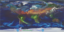
The extinction optical thickness of aerosols from a free running 10-km GEOS-5 Nature-Run including dust (red), sea salt (blue), black and organic carbon (green) and sulphate (white) are depicted from August 2006 through April 2007. GEOS-5 was run with the GOCART model providing feedbacks of the direct radiative effects of aerosols within the model in addition to their advection by the weather within the simulation.
Sea-salt (blue) is churned up from the ocean based on surface wind speeds, and most prevalent along mid-latitude storm tracks and frontal regions (including the Southern Ocean) and within the circulation and eye of tropical cyclones. Dust (red) is most prominent over the Saharan desert and can be seen interacting with a few Atlantic tropical cyclones during the end of the 2006 Atlantic hurricane season. Organic and black carbon (green) are dispensed into the atmosphere from biomass burning, the most prominent for this period being over South America from Aug-Oct 2006, Indonesia from Sept-Nov 2006, Africa in January 2007. Sulphate (white) can be seen from two primary sources, those being fossil fuel emissions over Asia, Europe and the US, and also from volcanic emissions, there is a persistently active volcanic emission from Mt Nyiragongo in the Democratic Republic of the Congo, Africa, and then a large eruption from the Karthala Volcano on Grand Comore Island, Comoros in January of 2007.