
Hurricane Katrina with GEOS-5 (10-years of model improvements)
Advances in high performance computing and scientific development have produced dramatic improvements in the capability of global models to simulate the most intense hurricanes around the world. Thanks to higher resolution models with improved representation of physical processes, advanced data assimilation techniques, and better supercomputers, today’s GEOS-5 simulations can recreate historical storms like Hurricane Katrina in 2005 with a fidelity far beyond our capabilities from 10 years ago.
As Hurricane Katrina approached the Gulf coast in August of 2005, global models at the time with resolutions of 100- to 50-km could provide marginal guidance on landfall location with errors on the order of 150km for a 3-day forecast and more than 300km for a 5-day forecast. These models provided virtually no indication of potential intensity. Today global models accuracy provides an additional day of lead-time for landfall forecasts and physics advances coupled with convection permitting resolutions down to 6km globally resolve the full intensity of major hurricanes with surface winds in excess of 110mph.
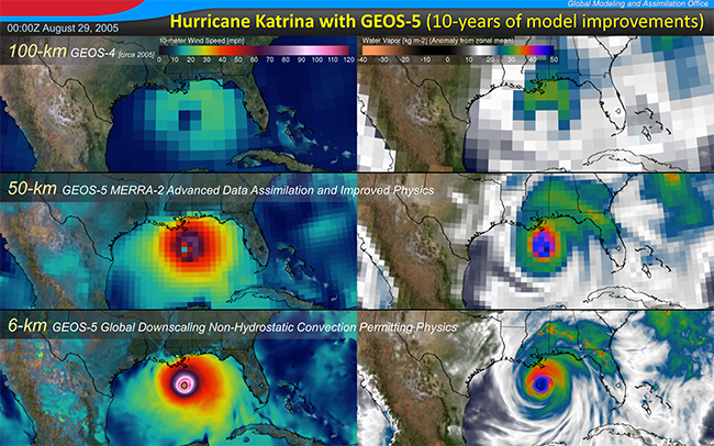
The images above reveal the dramatic improvement in NASA’s global atmospheric model and data assimilation system [the Goddard Earth Observing System model, version 5 (GEOS-5)] over the past decade. They show Katrina as a major hurricane poised to strike the Gulf coast on August 29th, 2005 at 00:00Z. Winds at 10-meters above the surface are shown on the left while water vapor is depicted on the right. The top row shows the analyzed state at this time from the operational GEOS-4 model and assimilation system in 2005 with a horizontal resolution of 100-km globally. The middle panel presents the same state from the modern GEOS-5 model and analysis system; this system has been executed for 35-years to produce the Modern-Era Retrospective Analysis for Research and Applications-2 (MERRA-2). The lower row shows a dynamically downscaled global simulation with GEOS-5 at 6km global resolution; this system is relaxed to a filtered version of MERRA-2 (incorporating information at ~600km every 6-hours) but is free to develop the fine scale structures of the convection permitting resolution at which it is being executed.
The impact of science changes from the GEOS-4 simulations to MERRA-2, with only marginal resolution improvement, highlight the improvements in our ability to ingest information from the observing system within our assimilation system and the improvements in model physics to better parameterize tropical convection at coarse resolution. The lower panel reveals where the state of the science of global models is evolving; at resolutions of just a few kilometers with convection permitting physics and non-hydrostatic global models like GEOS-5, the intensity of Hurricane Katrina, it’s inner core and well-defined eye are fully resolved and the spiraling bands of moisture fueling this intense storm become clearly evident.
See also: Since Katrina: NASA Advances Storm Models, Science