
GMAO RESEARCH HIGHLIGHTS, 2010-2012
Below are titles and descriptions of the GMAO Research Highlight entries from 2010 through 2012. These writeups are summaries of selected GMAO scientific research activities.
2012
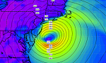 Tracking Hurricanes with GEOS-5
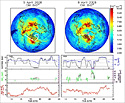
The GEOS-5 atmospheric model and assimilation analyses are used every day to generate 5-day weather forecasts. One view of GEOS-5 performance is provided from the forecasts of two of the most destructive storms of the 2012 hurricane season: Hurricanes Isaac and Sandy.
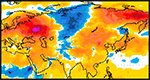 Attributing the 2010 Russian Heat Wave
The GMAO used GEOS-5 and MERRA to investigate the driving forces behind a major heat wave that occurred in western Russia in the summer of 2010 and to assess the predictability of such events.
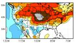 Drought in the United States
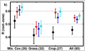
The GMAO engages in research to understand drought and its predictability. GEOS-5 and MERRA have been used to examine drought in the U.S. in 2011 and 2012. In investigating the processes that control drought, the GMAO strives to improve the forecasting of drought on seasonal time scales.
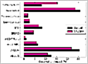 Assessing Observation Impacts in NWP: Atmospheric Motion Vector Winds
Observation impacts on weather forecasts: Atmospheric motion vector winds (AMVs) have a high impact on Navy weather forecasts, but only a modest impact on GEOS-5 forecasts. Recent investigation has focused on determining why this is the case.
2011
 GMAO article in GRL on how active and passive microwave data improve soil moisture estimates is highlighted in EOS
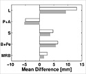
The paper, by Draper and colleagues, shows that assimilating satellite observations from active or passive microwave sensors into models can improve soil moisture estimates. The authors assimilated soil moisture derived from the active ASCAT and passive AMSR-E satellite sensors into a land surface model and assessed the resulting soil moisture estimates against in situ observations from 85 sites in the United States and Australia. They found that the active and passive microwave data both improved the model's soil moisture estimates in similar ways. Following the recent failure of AMSR-E, the new study shows that systems designed to assimilate AMSR-E soil moisture can switch to ASCAT data without loss of accuracy.
2010
 Assimilation of Terrestrial Water Storage from GRACE in a Snow-dominated Basin
In a recent study, gravimetric measurements from the Gravity Recovery and Climate Experiment (GRACE) mission are used in a land surface model data assimilation framework to better characterize snow conditions in the Mackenzie River basin located in northern Canada. The assimilation of GRACE terrestrial water storage information into the Catchment land surface model improves snow mass estimates.
 GEOS-5 Model used to interpret measurements of atmospheric bromine
Simulations of trace gases in GEOS-5 have been used to interpret atmospheric bromine measurements from NASA's OMI instrument and from aircraft in the ARCTAS field campaign. The work was led by Professor Ross Salawitch at the University of Maryland, and is featured in a Geophysics Research Letters Editor's highlight and on the cover of the November 16, 2010, issue of GRL.