
GMAO RESEARCH BRIEFS
Research in the GMAO emphasizes the use of satellite observations in global modeling systems, comprised of atmosphere, ocean, land-surface, and biogeochemistry model components. These components are integrated for assimilation and forecast systems to address questions about climate variability, water and energy budgets, composition, and weather and climate prediction; to form an integrated Earth system analysis; and to contribute to the design of future satellite missions.
Details about refereed scientific papers published by the GMAO staff are compiled on our GMAO Publications page.
This page lists titles and links to GMAO Research Briefs. These writeups are summaries of selected GMAO scientific research activities.
September 2020
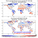
Impacts of new atmospheric physics in the updated GEOS FP system (Version 5.25)
 The January 2020 upgrade included major changes to the atmospheric component of the GEOS model. These updates led to improved marine stratocumulus clouds and reduced errors in cloud radiative forcing. Forecast skill is substantially
improved at all lead times out to five days.
The January 2020 upgrade included major changes to the atmospheric component of the GEOS model. These updates led to improved marine stratocumulus clouds and reduced errors in cloud radiative forcing. Forecast skill is substantially
improved at all lead times out to five days.
» Read Brief
June 2020
Transition to the RRTMG Shortwave Radiation Code in GEOS Models
 In January 2020, the GMAO introduced the shortwave component of the radiative transfer module RRTM for global climate model applications into the GEOS-FP analysis and prediction system. RRTMG is an efficient, actively maintained, modern and flexible code base better adapted for future model development.
» Read Brief
Ozone Data from Ultraviolet Satellite Measurements in GEOS Products
 Atmospheric ozone is a critically important component of the Earth system. This brief highlights the key aspects of UV-derived ozone data used in three publicly available GEOS products: the Modern-Era Retrospective Analysis for Research and Applications(MERRA-2), GEOS Forward Processing systems (GEOS-FP), and the GEOS Forward Processing for Instrument Teams (GEOS-FPIT) product.
» Read Brief
March 2020
Land-Focused Changes in the Updated GEOS FP System (Version 5.25)
 Changes imposed in the January 2020 upgrade from Version 5.22 to 5.25 of the Goddard Earth Observing System (GEOS) Forward Processing (FP) analysis system were designed to increase the realism of simulated land variables. This Research Brief documents the land-focused changes and their impact on the upgraded system.
» Read Brief
January 2020
Large-Scale Influences on Atmospheric River Induced Extreme Precipitation Events Along Coast of Wash. State
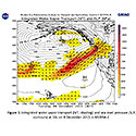 In order to accurately predict AR events in numerical weather prediction, subseasonal and seasonal timescales, it is important to understand the large-scale meteorological influence on extreme AR events. Here, characteristics of ARs that result in an extreme precipitation event are compared to typical ARs on the coast of Washington State.
» Read Brief
December 2019
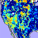
El Niño Related Tropical Land Surface Water and Energy Response in MERRA-2
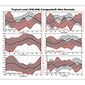 In this study, we combine several El Niño events as represented by MERRA-2, to develop a composite El Niño in order to isolate the most consistent processes. Results show that the El Niño sea surface temperature (SST) warming eventually causes less clouds over land and more solar energy to reach and warm the surface. Whileprecipitation is also reduced, it takes additional time for the soil water to dry and realize the full effect on the land temperatures. The GEOS model used in MERRA-2 also demonstrates these same features, though, most significant closer to the El Niño SST warming.
» Read Brief
October 2018
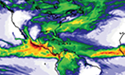
July 2018 Mid-Atlantic Atmospheric River and Extreme Precipitation Event Captured by MERRA-2
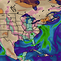 Beginning on July 21, 2018, an atmospheric river, a narrow stream of enhanced water vapor transport, positioned itself over the U.S. mid-Atlantic region resulting in record daily rainfall totals and extensive flash flood warnings as the entire monthsâ worth of precipitation fell in a matter of days. This rainfall event was clearly captured by GMAOâs Modern Era Retrospective analysis for Research and Applications, version 2 (MERRA-2).
» Read Brief
July 2018
Saildrone Baja Field Campaign: A Comparison of Surface Meteorology with GEOS Products
 The Saildrone Baja field campaign was an international effort to collect measurements across the air-sea interface for a 62-day period between April 11-June 11, 2018. The field campaign was executed using a saildrone, an unmanned surface vehicle (USV) carrying a comprehensive suite of instruments to measure meteorological, ocean surface, and subsurface data. We use these data to validate near-surface meteorology and ocean surface temperature fields in the GlobalEarth Observing System (GEOS). This is the first study using Saildrone data to validate GEOS products. As these USV platforms become more prevalent, they could be used to improve model representation of the air-sea interface variables.
» Read Brief
June 2017
Synoptic Scale Influences on Increasing Summertime Extreme Precipitation Events in the Northeastern United States
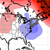 Over the past 15 years, the northeastern United States has seen a statistically significant increase in the frequency of extreme precipitation events that is larger and more widespread than anywhere else in the country. This increase in events is more likely to be associated with frontal and low-pressure systems, rather than being caused by more tropical cyclones impacting the region.
» Read Brief
Using SMAP Soil Moisture Data to Calibrate a Land Surface Model
 Soil moisture retrievals from the Soil Moisture Active Passive (SMAP) mission are used to evaluate and calibrate the treatment of soil moisture recharge in the GMAO Catchment land surface model. The improvements lead to better simulations of soil moisture and streamflow.
» Read Brief
May 2017
The Korea-United States Air Quality (KORUS-AQ) Campaign
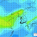 The GEOS-5 forecast model was used for near real time meteorological and aerosol forecasting and flight planning during the KORUS-AQ campaign. Evaluation of GEOS-5 against observations from the campaign will help to identify inaccuracies in the model's physical and chemical processes in the KORUS-AQ region and lead to refinements of the GEOS system.
» Read Brief
April 2017
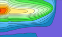
Quantifying chem. O3 loss in the Arctic stratosphere with GEOS-STRATCHEM DAS
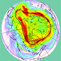 A new configuration of the Goddard Earth Observing System Data Assimilation System was used with a stratospheric chemistry model to study ozone depletion in the Arctic polar stratosphere during the exceptionally cold (in the stratosphere) winters 2015/2016 and 2010/2011.
» Read Brief
August 2016
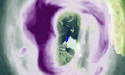
Southern Polar Ozone in MERRA-2
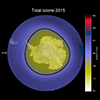 MERRA-2 provides a good representation of the year-to-year variations and the long-term changes in total ozone column over Antarctica for the entire data record, beginning in 1980. When MLS data are introduced into MERRA-2 in 2004, agreement with independent data improves compared to earlier years when the SBUV observations were assimilated. View animation: Total Ozone from 1980 to 2015.
» Read Brief